The remains of the Castle can be visited
CastleUnterengstringen
Glanzenberg Castle (Ruin) (Unterengstringen)
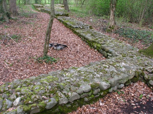
The Glanzenberg ruin in Unterengstringen, Canton Zurich, is a fascinating testament to medieval architecture and history. This former castle, which once stood on a promontory directly above the historical course of the Limmat River, today offers an exciting insight into the territorial power struggles of the 13th century and the ambitions of the Barons of Regensberg.
History+
The origins of the complex date back to the 12th century, with archaeological finds and ceramic remains indicating settlement until the 14th century. In the course of their rivalry with the burgeoning city of Zurich, the Regensbergers expanded the existing Fahr Castle in the early 13th century. Around 1240, they founded the adjacent town of Glanzenberg, strategically located to control Limmat trade and as a potential bridge site. An inheritance division around 1250 between Lütold VI and Ulrich von Regensberg resulted in Ulrich receiving possessions in Glanzenberg. In 1257, the people of Zurich prevented the construction of a Limmat bridge by obliging the Knights of Schönenwerd to refrain from selling land. Late medieval chronicles report a violent destruction of Glanzenberg by the people of Zurich in 1267, although archaeological evidence for this is not conclusive. The castle was abandoned around 1267 and later used as a quarry. Over the centuries, the Limmat eroded parts of the subsoil. In the 17th and 18th centuries, the site still played a role in military conflicts, such as the Second Villmergen War and the Second Battle of Zurich.
Location+
The Glanzenberg ruin is located in Unterengstringen in the Dietikon district, Canton Zurich, Switzerland, at an altitude of approx. 394 m above sea level.
On site+
Today, the restored Glanzenberg ruin can be visited freely. Parts of the double moat and a section of the polygonal ring wall, made of massive boulders, which once surrounded the castle plateau with the residential tower, are preserved. The excavation and conservation of the remains took place in several phases, most recently until 1981.
Nearby+
- Schönenwerd Ruin (Dietikon) (Castle), approx. 0.6 km away
- Weiningen Castle (Castle), approx. 2.3 km away
- Uitikon Castle (Castle), approx. 4.2 km away
- Kindhausen Castle Ruin (Castle), approx. 4.4 km away
Take Mobile History with you
You are reading this text for free. Premium adds what matters on the road: descriptions read aloud, sites found through your camera, whole regions taken offline.
- Every description, including the ~17,700 Premium sites
- Audio guide: have descriptions read to you on location
- AR finder: see sites through your camera, with distance and bearing
- Unlimited saved sites
14 days free, then from €2.99 a month. Cancel anytime.
Source: Wikipedia · Licence: CC BY-SA 4.0
This description draws on the facts documented in the linked Wikipedia article; Wikipedia content is licensed under CC BY-SA 4.0. Wording and editing: Mobile History.
Location: 47.4021, 8.4221