The remains of the Castle can be visited
RuinGelblingen
Geyersburg Castle (Ruin)
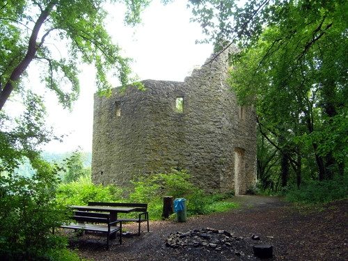
The castle ruin Geyersburg, temporarily also called Gartenheuslin, is located in the municipality of Untermünkheim in the district of Schwäbisch Hall in Baden-Württemberg.
The Geyersburg is situated on a very narrow mountain ridge, which tapers off to about 500 meters in the east-northeast, at an altitude approximately above the Kocher valley, where the southern municipal boundary of Untermünkheim to the city of Schwäbisch Hall also runs. A few steps to the southeast, the terrain drops over the Eichelhalde, which is wooded at the top and shows remnants of vineyard walls at the bottom, with a gradient of about 30% to the bottom of the Kocher valley, where the river begins to form an eastern loop. To the north, the terrain slopes much more gently down to the Fohlenweide, the valley terrace of an old western valley loop, the center of which is occupied by the Lindenhof farmstead about 400 meters north of the ruin and about 20 meters above the current valley floor. The next larger settlement near the Geyersburg is the Schwäbisch Hall hamlet of Sülz, just under a kilometer to the southwest, from which the castle is also easiest to reach. About 700 meters southwest, beyond the Kocher, on the Umlaufberg Neuberg of the river's Gelbingen western loop, lie the ruins of the Neuburg.
The hilltop castle was built in 1391 by the Feldner (Veldner) family. In 1402, a Hans Feldner, known as Geyer, is documented in connection with Ulrich von Hohenlohe and the fief of the Geyersburg fortress. Afterwards, the castle came into the possession of the city of Hall, which sold it to Rudolf von Münkheim in 1406. He lost the castle for financial reasons, and so it came into the fief of Haller citizens. Whether the castle was destroyed or fell into disrepair is unclear. After the extinction of the Lords of Münkheim in 1507, it lost its importance. During the Peasants' War, a group of peasants hid in the fortress, which was then called Gartenheuslin. In 1982, the ruin was renovated and is freely accessible.
Description+
The castle complex featured a partially preserved three-story residential tower (built of Muschelkalk stones) with an octagonal floor plan and 1.5 meter thick walls, as well as a basement accessible via a stone staircase. In the outer wall, embrasure-like openings and on the upper floor large rectangular windows with window seats can be seen. Furthermore, the complex had section ditches and a shield wall.
Take Mobile History with you
You are reading this text for free. Premium adds what matters on the road: descriptions read aloud, sites found through your camera, whole regions taken offline.
- Every description, including the ~17,700 Premium sites
- Audio guide: have descriptions read to you on location
- AR finder: see sites through your camera, with distance and bearing
- Unlimited saved sites
14 days free, then from €2.99 a month. Cancel anytime.
Source: Wikipedia · Licence: CC BY-SA 4.0
This description draws on the facts documented in the linked Wikipedia article; Wikipedia content is licensed under CC BY-SA 4.0. Wording and editing: Mobile History.
Location: 49.1355, 9.7275