The remains of the Castle can be visited
RuinBad Emstal
Falkenstein Castle (Ruin) (Bad Emstal)
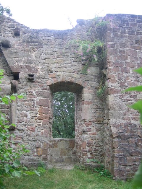
The Falkenstein castle ruin is a Romanesque castle complex near Bad Emstal-Sand in the North Hessian district of Kassel.
The ruin is located in the Habichtswald Nature Park, about 2.5 km east-northeast of the Bad Emstal district of Sand, on the now forested basalt peak of Falkenstein, north-northwest of Niedenstein and southwest of Schauenburg-Elmshagen. The border to the town of Niedenstein runs along the southern flank of the mountain, and the border to the municipality of Schauenburg runs along the eastern flank. Because the mountain peak slopes steeply to the north and east, it and thus the castle ruin are best reached from the south via hiking trails. The upper course of the Eder tributary Ems runs west past the mountain, and the Ems tributary Wiehoff passes to its east.
Like the neighboring Altenburg to the southwest, the Falkenstein mountain peak was already settled by the Chatti.
Falkenstein Castle, probably built towards the end of the 13th century, is first mentioned in a document in 1346. In that year, Landgrave Heinrich II of Hesse pledged the castle, which was probably already in disrepair, to the Lords Hund von Kirchberg and Holzhausen for 452 marks of silver, but with the obligation to spend at least 170 marks of silver on its reconstruction. The two branches of the Hund family simultaneously received a castle fief each. The Landgrave was only allowed to redeem the castle from the heirs of the pledge holders after their death, but the latter were to keep the castle fiefs and castle seats they had built on the castle forever. On the other hand, the castle was to be open to the Landgrave against enemies at all times. Already in 1351, a chapel on the castle is mentioned again. Protests by Archbishop Gerlach of Mainz against the reconstruction of the castle were rejected and dropped in 1354. On September 13, 1363, the numerous members of the Hund family concluded a castle peace on Falkenstein, but shortly thereafter the Holzhausen line lost its share of the castle due to a dispute with the Landgrave. Landgrave Hermann II initially gave this half, due to the hostile behavior of the Hund in the Sterner War, to Ludwig von Wildungen on April 6, 1387, but then in the same year to Ekkebrecht von Grifte as a reward for his successful defense of Obernburg in Gudensberg against a besieging army of Archbishop Adolf I of Mainz, Landgrave Balthasar of Thuringia, and Duke Otto of Brunswick-Göttingen.
In 1388, a new treaty was concluded between Landgrave Hermann and the Hund, in which the pledge conditions of 1346 and the castle peace of 1363 were declared invalid, and the Hund's shares of the castle were enfeoffed to the Landgrave. After the extinction of the Holzhausen line of the Hund in 1430, an inheritance dispute arose between the Hund from Kirchberg on the one hand and Reinhard von Dalwigk, a nephew of the deceased Otto von Holzhausen, and the Knights of Grifte on the other, which the Landgrave was only able to settle with considerable effort and after a long time in 1442. Reinhard von Dalwigk sold his claim in 1454 for 100 guilders to the von Grifte.
Until 1569, the castle then belonged jointly to the Lords of Grifte and the Hund family, which they then held jointly as a Hessian landgravial male fief from 1569. In 1597, the Lords of Grifte died out, and the castle increasingly fell into disrepair. It can be assumed that the successors were only enfeoffed with the forest, the mountain, and the associated lands, but no longer with the castle. In 1631, Tilly's troops destroyed the castle. After the death of Lieutenant Colonel Hans Heinrich Hund zu Freienhagen (called Canis) in 1679, the castle finally fell into ruin and reverted to the Hessian Landgrave as an expired fief.
Castle Ruin+
The narrow, round plateau area of Falkenstein mountain has a diameter of 30 m. South of Falkenstein Castle was a 40 m wide outer bailey. Only a few wall remains of the palas have been preserved. A continuous 11 m long section of wall in the south and two high, narrow sections of wall, between which there was a window, attest to the settlement. Remains of the moat and rampart system are still visible in the west.
Take Mobile History with you
You are reading this text for free. Premium adds what matters on the road: descriptions read aloud, sites found through your camera, whole regions taken offline.
- Every description, including the ~17,700 Premium sites
- Audio guide: have descriptions read to you on location
- AR finder: see sites through your camera, with distance and bearing
- Unlimited saved sites
14 days free, then from €2.99 a month. Cancel anytime.
Source: Wikipedia · Licence: CC BY-SA 4.0
This description draws on the facts documented in the linked Wikipedia article; Wikipedia content is licensed under CC BY-SA 4.0. Wording and editing: Mobile History.
Location: 51.2539, 9.2958