The remains of the Castle can be visited
RuinThiergarten
Falkenstein Castle (Ruin)
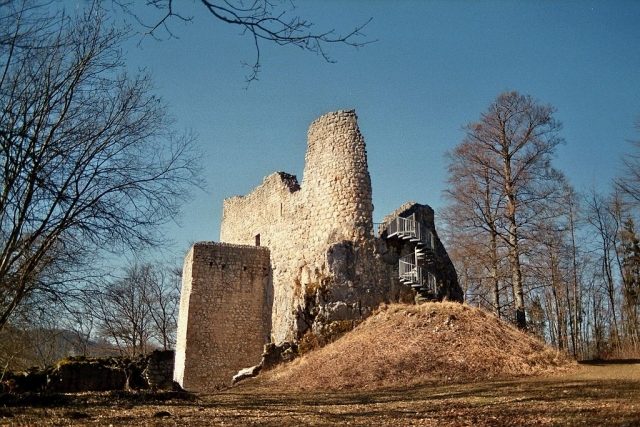
The castle ruin Falkenstein is located between the villages of Neidingen and Thiergarten, about 150 meters above the valley floor in the Upper Danube Nature Park. A distinction is made between Oberfalkenstein (Upper Falkenstein) and Unterfalkenstein (Lower Falkenstein). The Falkenstein ruin is one of the best-preserved ruins in the Danube Valley, Oberfalkenstein is the most remarkable ruin of the Upper Danube Valley.
Research suggests that Oberfalkenstein and Unterfalkenstein should be considered independent castles due to the layout of both complexes and documentary evidence:
- Unterfalkenstein, with only a few remaining wall fragments, is located on a rock spur above the Neumühle. Ceramic finds indicate that it is the older of the two castles (approx. 1100 - 1150). Entering the ruin is prohibited.
- Oberfalkenstein was built as a modern complex between 1516 and 1545, incorporating a predecessor castle, and, unlike other Danube Valley castles, is situated in the middle of an elongated, rocky ridge, on the edge that slopes steeply southwards to the Danube. To the north, the mountain slopes down towards the "Buttenloch". This side valley between Falkenstein and Mittelberg, an Umlaufberg (isolated hill formed by a river meander), is a pre-glacial course of the Danube (today's Danube level). The significant ruin remains of the core castle are freely accessible and secured.
Purchase and donation deeds from the 14th and 15th centuries clearly distinguish between the Upper and Lower Castles, which were also sold independently of each other and were often in different structural conditions. However, this does not preclude the possibility that they may have temporarily formed a structural unit.
Falkenstein Castle, after which a knightly family named itself in the 13th century, was already in the possession of the Counts of Lupfen at the beginning of the 14th century.
In 1516, Gottfried Werner von Zimmern acquired Falkenstein Castle for 4800 guilders, along with Kreenhainstetten, Reinstetten, Weiler, and the mill at Neidingen, from Wolf von Bubenhofen. Unterfalkenstein was referred to as a "Burgstall" (site of a former castle) at this time. He immediately began with the expansion. This expansion, similar to his neighboring castle project Wildenstein, was carried out according to the technical standards of the time, taking into account the contemporary artillery technology. He had a high tower above the castle chapel, which, although it provided a view as far as Mengen, swayed dangerously in strong winds, demolished. Similar to Wildenstein Castle, the rock beneath the walls was leveled flush, so that the transition between masonry and rock was seamless.
The Counts of Zimmern transformed the castle into a kind of hunting and representative residence in the new Renaissance style, with large windows and leaded glass panes. With their own glass production – in 1978 a large crucible with traces of glass was found, and in 2010 eleven quartz sand pits were discovered around the castle – the Counts of Zimmern could cover their immense needs themselves: windows, goblets, jugs, and bottles were produced by their own master craftsmen. They kept their recipe secret. Falkenstein Castle is considered to be the only castle in the Danube Valley where glass production has been proven.
In 1525, Gottfried Werner sold Falkenstein to his brother Johannes Werner, with the associated villages being sold to Sixt von Hausen for only 400 guilders.
After 1528, Johannes Werner continued to expand Falkenstein. In 1575, Wilhelm von Zimmern had a game enclosure built near the castle on the Danube, from which the village of Thiergarten later emerged.
With the Zimmern possessions, the Princely House of Fürstenberg inherited Falkenstein in 1627. In the 17th century, the castle was described as uninhabitable.
Renovation
Over the years, the Falkenstein ruin had become overgrown. Trees and bushes covered the walls, and the masonry had broken away. Structural securing of the ruin was urgently needed. Between 1977 and 1989, Falkenstein was extensively renovated by the "Aktion Ruinenschutz Oberes Donautal" (Upper Danube Valley Ruin Protection Campaign) in cooperation with experts from the State Monuments Office of Baden-Württemberg. Archaeological excavations took place in 1978. The castle courtyard of the core castle of Oberfalkenstein was cleared of fallen masonry. During this work, a previously unknown cistern driven into the rock was discovered. Upon completion of the structural securing, the ruin of Oberfalkenstein was made accessible to everyone. The ascent to Unterfalkenstein was equipped with hooks for safety. It has since been closed again to climbers, as the remaining masonry almost completely collapsed into the depths.
In the years that followed, Oberfalkenstein became overgrown again, and the renovated masonry had broken away in some places. For this reason, the "Aktion Ruinenschutz Oberes Donautal" was reactivated in 2006. In many hours of voluntary work in 2006, the broken masonry was repaired under the supervision of the State Office for Monument Preservation Baden-Württemberg, and signage was installed. These new signs point to the structure and its history. The work was carried out with the help of the Dietfurt Mountain Rescue and a school class. In early summer 2007, the ruin was cleared and cleaned.
Description+
The castle complexes of Oberfalkenstein and Unterfalkenstein differ fundamentally: Unterfalkenstein, a rock castle, is located about 50 meters west of Oberfalkenstein, built on two rocks – the outer fortification (12 × 9 meters) and the core castle (slightly larger) were connected by a bridge. Oberfalkenstein, on the other hand, is a spacious complex. Remains of an outer boundary wall on the south, east, and north sides, which included the moat, indicate an area of approximately 5000 square meters. A barbican was recently found as a protective structure for the castle. The outer bailey on the south side (45 × 20 meters) was delimited from this by an outer wall. The core castle of Oberfalkenstein is located on an almost 20-meter-high and approximately 40-meter-long rock base, which was accessed by a stair ramp via the outer bailey. On the attack side (from Thiergarten), the masonry was more robust and originally secured by a tower. The stair ramp ended about four meters before the south tower; a drawbridge or bascule bridge is conceivable. Besides these two towers, Oberfalkenstein also had a north tower, bastion-like with embrasures in the Wildenstein style.
Location of Finds+
The finds made between 1977 and 1990, such as ceramic plates from tiled stoves, fragments of ceramic and glass vessels, fittings, projectiles, three stone sling balls, and other items, are managed by the Tübingen Regional Council, Department of Monument Preservation. All glass finds are stored in the central find archive in Rastatt, which is subordinate to the State Office for Monument Preservation. From April 16 to May 31, 2010, the exhibits were shown in the exhibition "Falkenstein – History and Exhibits" at the Haus der Natur Beuron by the "Aktion Ruinenschutz Oberes Donautal". With this exhibition, excavation finds from a former castle in the Danube Valley were presented to the public for the first time.
Falkenstein Altar+
In the chapel of Oberfalkenstein, located in the palas, was the so-called "Falkenstein Altar". This four-winged work is believed to have been created by the anonymous Master of Meßkirch around the year 1525. It was moved by the Fürstenberg family to Donaueschingen. Today it is located in a side wing of the Staatsgalerie Stuttgart.
Take Mobile History with you
You are reading this text for free. Premium adds what matters on the road: descriptions read aloud, sites found through your camera, whole regions taken offline.
- Every description, including the ~17,700 Premium sites
- Audio guide: have descriptions read to you on location
- AR finder: see sites through your camera, with distance and bearing
- Unlimited saved sites
14 days free, then from €2.99 a month. Cancel anytime.
Source: Wikipedia · Licence: CC BY-SA 4.0
This description draws on the facts documented in the linked Wikipedia article; Wikipedia content is licensed under CC BY-SA 4.0. Wording and editing: Mobile History.
Location: 48.0836, 9.0825