The remains of the Castle can be visited
RuinEttensberg
Ettensberg Castle (Ruin)
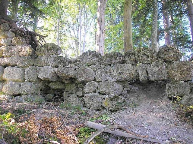
The ruin of Ettensberg Castle is located on a mountain spur west of the municipality of Blaichach in the district of Oberallgäu in Swabia. The few, highly endangered remains of the relatively small castle complex are freely accessible.
The fortress probably originated as early as the end of the 11th century as the seat of a ministerialis of the Prince-Bishopric of Augsburg. Whether a Luitgard von Outensperch, mentioned in 1147, is connected with the castle cannot be definitively determined.
Only in 1377 is a Benz Oetisperg documented as a seal witness. Like most lower nobility of this era, he probably had to forgo knighthood, being merely a squire without the accolade or dubbing.
Around 1409, the Counts of Montfort took over the small lordship, which lay in the middle of their sovereign territory. The fortress was garrisoned with bailiffs who came from the surrounding knighthood. Konrad von Laubenberg is recorded as the first bailiff, who was replaced by Swigger von Rauns as early as 1410.
From 1446 to 1466, the castle served Countess Beatrix von Montfort as a widow's residence. In 1457, she endowed an anniversary mass in the church of Blaichach and is said to be buried there.
In 1562, Jakob Guthainz from Immenstadt was once again enfeoffed with the castle as a bailiff. Only two years later, the fortress was already abandoned and was referred to as a "Burgstall" (castle site) when the County of Rothenfels was sold.
In the following centuries, the ruins of the complex served the population as a welcome quarry. In 1934, a memorial stone was erected in the castle courtyard, which tells the history of the small fortress. Such monuments usually go back to the Kempten mayor and passionate castle researcher Otto Merkt, who often financed the stones and plaques out of his own pocket.
After the Second World War, only foundation remains up to a height of about 2.5 meters were preserved, which were partially excavated in 1948 and are documented in the inventory volume of 1964. In autumn 2008, the castle ruin was in a desolate state. Especially in the area of the keep, the masonry had completely disappeared except for one layer of stone in the east.
Description+
The small castle ruin is located about 500 meters southwest of the parish church of Blaichach on an elongated mountain ridge (737 meters above sea level) above the Iller Valley. Access is via the almost flat, very long ridge, which connects the castle site with the mountain massif rising behind it. The ridge is on average only about 15 to 20 meters wide. On the other sides, the terrain sometimes drops very steeply into the valley.
At the eastern end of the mountain spur, a partially buried neck ditch, cut into the Nagelfluh rock, protects the castle. To the south, a later material pit encroaches into the ditch area.
Behind the pit, a prominent motte rises about eight meters high. Here, on the attack side, stood the keep, a former residential tower with a side length of about 11.30 meters square. Of the foundation remains made of Nagelfluh ashlar, documented by Nessler and in the inventory volume on three sides up to a height of 2.5 meters (south side), only one layer of stone has been preserved in the east. The castle gate was located north of the main tower and has completely disappeared.
The regular ground plan of the main castle (approx. 35 x 24 meters) can now only be seen on older plan drawings. Only in the northeast does a higher piece of wall made of mighty Nagelfluh ashlar still stand upright as a retaining wall, behind which the terrain slopes down to a small terrace. This is probably where the castle's residential buildings were located. The excavations of 1948 indicate three rooms on the ground floor. Some other wall lines appear as rubble mounds in the terrain.
The desolate state of the few remaining castle ruins gives rise to fears of the complete loss of one of the oldest tower castles in the Allgäu in the coming decades.
Take Mobile History with you
You are reading this text for free. Premium adds what matters on the road: descriptions read aloud, sites found through your camera, whole regions taken offline.
- Every description, including the ~17,700 Premium sites
- Audio guide: have descriptions read to you on location
- AR finder: see sites through your camera, with distance and bearing
- Unlimited saved sites
14 days free, then from €2.99 a month. Cancel anytime.
Source: Wikipedia · Licence: CC BY-SA 4.0
This description draws on the facts documented in the linked Wikipedia article; Wikipedia content is licensed under CC BY-SA 4.0. Wording and editing: Mobile History.
Location: 47.5410, 10.2525