The remains of the Castle can be visited
CastlePfeffingen
Engenstein Castle (Ruin)
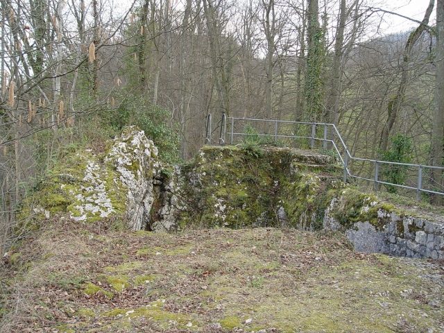
The Engenstein ruin is located on the few hundred-meter-long section of the Aescher Burgengratweg (castle ridge path) between the Schalberg ruin and the Münchsberg ruin. It lies on a rather small rock outcrop, which can now be climbed via a metal ladder (at your own risk). The narrowness of this complex, resulting from the small size of this rock outcrop – which was more suitable for building a 'fortified house' than a castle – probably gave it its name.
The complex, also known as Vorder-Schalberg or Alt-Schalberg, lies between the remains of Münchsberg Castle (only 280 meters as the crow flies) and those of the former Schalberg Castle. The access to the complex originally led steeply from the west over the rock ridge and must have been so narrow that it was probably only passable by people.
The surface of the rock outcrop had been artificially leveled, and in the eastern part of this level, a cellar was hewn into the rock (see photo). The cellar stairs carved out of the rock are still passable today. The beam holes in the cellar wall, which supported the beam ceiling above the cellar, are also still very clearly visible.
The last excavations took place from 1963 to 1970 by a private working group. All finds are exhibited in the Aesch Local History Museum.
The castle stood on Schaler's own property – which suggests construction by the Schaler family – and probably served as the manor house and residence of the Basel noble family of Schaler before the completion of Schalberg Castle. From here to Schalberg is only a scant 100 meters, and there is visual contact. It was presumably built by the Schaler family in the first quarter of the 13th century. Ground finds allow the assumption that the most intensive use took place in the second half of the 13th century. It can be assumed that it lost much of its importance with the construction of Schalberg Castle: few ground finds attributed to the 14th century support the assumption that it was still used to a reduced extent. This ruin, together with Schalberg Castle, passed to the Counts of Thierstein (as an episcopal fief) when the Schaler family died out in the 14th century.
The ruin was unknown due to a lack of sources and was discovered by Walther Merz shortly after the turn of the 19th to the 20th century. In 1975, it was excavated and conserved.
Take Mobile History with you
You are reading this text for free. Premium adds what matters on the road: descriptions read aloud, sites found through your camera, whole regions taken offline.
- Every description, including the ~17,700 Premium sites
- Audio guide: have descriptions read to you on location
- AR finder: see sites through your camera, with distance and bearing
- Unlimited saved sites
14 days free, then from €2.99 a month. Cancel anytime.
Source: Wikipedia · Licence: CC BY-SA 4.0
This description draws on the facts documented in the linked Wikipedia article; Wikipedia content is licensed under CC BY-SA 4.0. Wording and editing: Mobile History.
Location: 47.4644, 7.5691