The remains of the Castle can be visited
CastlePutz
Castels Castle (Ruin) (Putz)
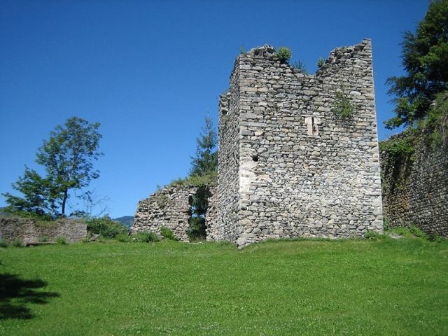
The ruins of Castels Castle, also known as Putzerburg, are located near the village of Putz in the municipality of Luzein in the Prättigau valley, in the Swiss canton of Graubünden.
Name+
Here, the name only seemingly has a direct relationship to the feudal castle; instead, it derives from an older Rhaeto-Romanic term for a refuge castle, which was adopted by the German-speaking builders or owners. This is reflected in documents from the 14th and 15th centuries: 1344: …dem manne Ulrichen von Kastels, 1352: in seinem gerichte genant zu Castels, 1496: die vesten oder geslos Castel and 1496 sloss Castel. The formerly Rhaeto-Romanic population apparently found the duplication "Castle at Castels" disturbing and named the complex after the nearby settlement "Castelg da Putz". Around 1573, Ulrich Campell reported: "…viculus Puotz dictus … quae Raetis inde antiquitus vocatur ils Castelg da Puntz, id est Castellum Putiense, Germanice loquentes dicunt Castels."
Layout+
The complex is situated on a rocky outcrop that drops vertically to the Landquart river to the south. Several masonry joints indicate that the castle was built in several phases. To the east and west, the complex was protected by steep slopes, and to the north by a ditch-like depression. A curtain wall follows the contour of the terrain. On the northern wall, remnants of a battlement with merlons and embrasures for hand firearms, built only in the 16th or 17th century, are visible. The current entrance gate was later broken through and fortified with a barbican equipped with embrasures, of which remnants remain. The original access was probably on the west side, where a narrow rock ledge leads around the curtain wall. When the gate was relocated, the rock ledge was blocked by a traverse.
From the current entrance to the southeast corner, a narrow Zwinger (outer ward) extended, its outer wall equipped with embrasures and a shell tower.
In the northwest corner stands a free-standing tower with a side length of approx. 8.5 m and a wall thickness of 2 m. It is separated from the inner bailey by a 2 m wide corridor. The corner bonds are carefully executed with bossed ashlar stones with a drafted margin. Remnants of a smooth plaster from the 16th century are visible on the tower. Four storeys are verifiable; the elevated entrance was on the west side on the 2nd storey and was accessible via a wooden structure between the wall and the tower.
Only a few traces of the rest of the complex have been preserved. In the west and southwest, there are remnants of the main wing leaning against the wall. According to an inventory from 1616, it contained the following rooms: a large living room with paintings, cupboards, a wall table, and Italian leather armchairs, a bedroom on one side, and a "Stübli" (small room) on the other. On the same floor was a "Saal" (hall), which, however, served as a sleeping area, and a small chamber. On the other side, separated by a hallway, were a living room, a chamber, plus the kitchen and a chapel.
Below this residential floor was the basement with vaulted rooms, the grain and wine storage, the butchery, and the servants' chamber.
In the courtyard stood a well, fed by a supply line. Near it stood a granary, a bathhouse, and a laundry oven, as well as a pigsty. The location of these buildings can no longer be determined without excavations. In the 17th century, the tower served as a prison and armory. Below was a dungeon with hand and foot shackles, as well as a "ufzug sambt einem neuwen Seil, daran die gefangenen auf- und abzelassen" (lift with a new rope, by which the prisoners were lowered and raised).
Documentary evidence regarding the construction of the castle is missing. It is conceivable that it was a refuge, possibly even a church castle from the early Middle Ages, which was converted into a feudal castle in the 13th century. The tower was probably built around 1200, the oldest parts of the inner bailey likely date from the 13th century, and extensions were made until the 16th and 17th centuries.
A noble family "von Castels" is not documented. In the 14th century, Castels belonged to the Prättigau dominion of Ulrich von Aspermont. How the castle came into his possession is unclear. His heirs sold the castle and estates of Castels in 1338 to Friedrich von Toggenburg and Ulrich von Matsch. In 1344, the two buyers divided the property, with the castle falling to the Matsch family.
In 1394, Castels was in the possession of the Toggenburgers, as Count Friedrich issued a document "ze Castell in vnsrer vesty" (at Castels in our fortress). After the death of the Toggenburger in 1436, Castels returned to the Matsch family; in 1446, there is mention of interest payments that were to be made to Ulrich von Matsch "gen Castels zuo vnser vesti" (to Castels to our fortress). Castels Castle and court served several times as collateral for debts of Gaudenz von Matsch, who temporarily resided in the castle. In 1496, he sold the complex to Emperor Maximilian. In the Swabian War, the castle was captured by the Bündners on February 16 or 17, 1499, but returned to the Austrians after the peace treaty; in November 1499, an Austrian Vogt, Hans Schuler from Davos, was once again in Castels.
In the 16th century, Castels was the administrative center of Austrian rights in the Prättigau. In 1622, the castle was besieged by the Bündners. After the water supply was cut off, the castle surrendered on April 25 and was partially destroyed. Already in September, it was recaptured by Count Sulz. In the Peace of Lindau on September 6, 1622, it was determined that the Bündners would have to rebuild the castle and compensate for the damage. Whether this happened is unclear. In 1649, the people of Prättigau bought their freedom from Austria. Castels Castle was destroyed by the Bündners and has been a ruin ever since.
Take Mobile History with you
You are reading this text for free. Premium adds what matters on the road: descriptions read aloud, sites found through your camera, whole regions taken offline.
- Every description, including the ~17,700 Premium sites
- Audio guide: have descriptions read to you on location
- AR finder: see sites through your camera, with distance and bearing
- Unlimited saved sites
14 days free, then from €2.99 a month. Cancel anytime.
Source: Wikipedia · Licence: CC BY-SA 4.0
This description draws on the facts documented in the linked Wikipedia article; Wikipedia content is licensed under CC BY-SA 4.0. Wording and editing: Mobile History.
Location: 46.9248, 9.7449