The remains of the Castle can be visited
CastleAndeer
Cagliatscha Castle (Ruin) (Andeer)
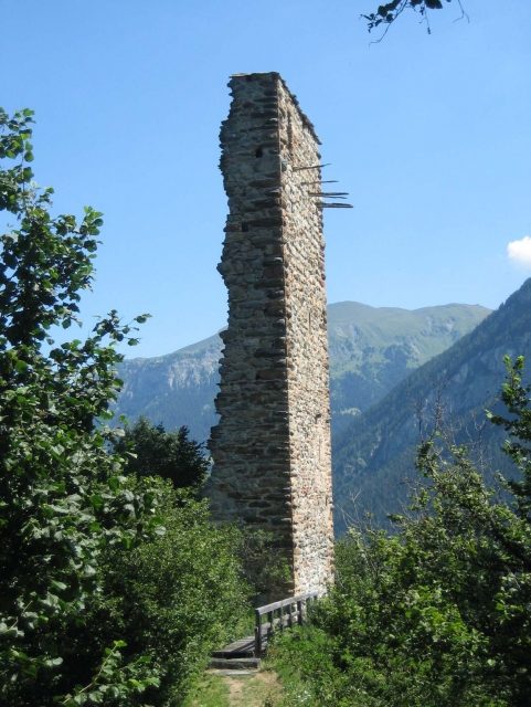
The ruin of Cagliatscha Castle is located in the municipality of Andeer, Clugin district, in Schams in the Swiss canton of Graubünden.
Location+
The ruin of Cagliatscha Castle is situated between Andeer and Clugin on a rocky outcrop high above the valley. It can be easily reached from Clugin via a hiking trail in a good twenty minutes. In front of the ruin is a picnic area with a fire pit and a fountain.
Structure+
Of the originally five-story defensive tower, only the approximately 8.5-meter-long southeast wall remains, as well as the beginnings of the adjacent walls. On the inside, the division of the floors can be read from the plasterwork. The wall thickness at the bottom is 2.3 meters and tapers towards the top to 1.75 meters. The different colored stones from which the tower was built are striking. The cornerstones, long bossed ashlar blocks, show precise edge dressing.
The mighty keep was surrounded on its two uppermost floors by a widely projecting wooden defensive gallery. The original access to the tower was on the second floor of the northeast wall and was probably moved to the third floor for strategic reasons. Half of it has been preserved at the edge of the break. No traces of a curtain wall were found. A dendrochronological examination of a roof beam indicated a construction period in 1266. This makes the roof of Cagliatscha the oldest original roof structure in Switzerland.
Documentary evidence regarding the origin and history of the Cagliatscha tower is completely lacking. A local family of ministeriales of the Barons of Vaz is assumed to be the builder; possibly the respected Schams family Panigad, who owned properties in Clugin and whose coat of arms, among others, is carved into the plaster on the third floor. A dendrochronological examination of a larch beam indicated a construction period around the year 1265. It is assumed that the tower was destroyed in connection with the Schamserfehde; rock debris still lies in the ravine below the ruin today. Ulrich Campell mentions it around 1570 as Castellatsch, meaning a bad, destroyed castle.
In 1984/85, the tower was secured by the Graubünden Castle Association, and a bridge was built over the neck ditch. In spring 2009, a plaque was erected near the ruin with comprehensive information about the construction and history of the castle.
The area northwest of the ruin is called "Padnal", which indicates a prehistoric settlement.
Take Mobile History with you
You are reading this text for free. Premium adds what matters on the road: descriptions read aloud, sites found through your camera, whole regions taken offline.
- Every description, including the ~17,700 Premium sites
- Audio guide: have descriptions read to you on location
- AR finder: see sites through your camera, with distance and bearing
- Unlimited saved sites
14 days free, then from €2.99 a month. Cancel anytime.
Source: Wikipedia · Licence: CC BY-SA 4.0
This description draws on the facts documented in the linked Wikipedia article; Wikipedia content is licensed under CC BY-SA 4.0. Wording and editing: Mobile History.
Location: 46.6137, 9.4222