The remains of the Castle can be visited
RuinBurgberg
Burgberg Castle (Ruin)
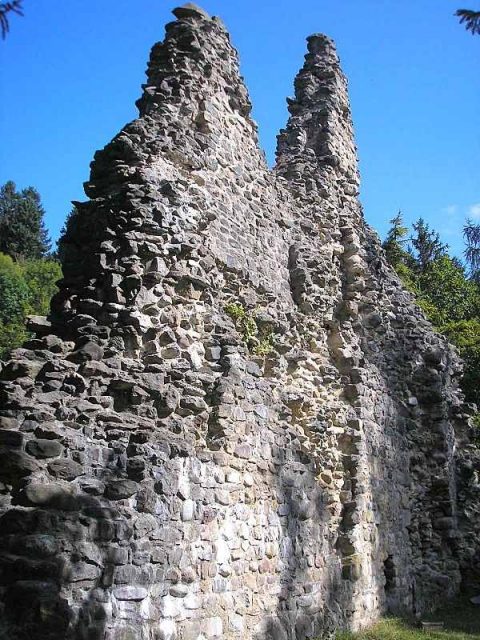
The ruin of Burgberg Castle (also: Heimenhofen Castle) lies on a rock outcrop above Burgberg in Allgäu in the district of Oberallgäu in Swabia. The partially preserved north wall of the small fortress was carefully secured and slightly supplemented between 1992 and 1997.
In 1140, a Burkart von Burgberg (Burcperg) appears in written sources as a ministerialis of the Prince-Bishopric of Augsburg. The ministerialis is mentioned as a benefactor of the monasteries of Ottobeuren and St. Ulrich and Afra in Augsburg. Around 1140, a Wernher von Burgberg is also documented as a benefactor of the Augsburg monastery and the new foundation of Ursberg.
The hilltop castle likely originated in the early 12th century. The north wall of a residential tower from this first complex has been preserved, which is of particular interest for regional castle research as one of the oldest Allgäu examples of such a main tower.
After the death of the last Burgberg lords Wernher and Johannes, the lordship passed to the Lords of Rettenberg around 1327. When the last Rettenberg died in 1350, his daughters divided their father's property. Burgberg Castle was awarded to Adelheid von Rettenberg, married to von Waldburg, who sold the fortress as early as 1351 to the brothers Marquard and Oswald von Heimenhofen. The purchase price is recorded as 2040 pounds of Konstanz currency.
In 1361, the brothers divided the property. Burgberg remained with Marquard von Heimenhofen. His brother Oswald acquired the neighboring lordship of Berghofen and began building his new Fluhenstein Castle, whose heavily dilapidated ruins have been preserved on the outskirts of Sonthofen.
In 1440, part of the lordship fell to the Diocese of Augsburg. Due to financial difficulties, Burkart and Konrad von Heimenhofen had to sell further shares to the Counts of Montfort zu Rothenfels near Immenstadt in 1468. The brothers appear in the sources as "poor housekeepers".
Jörg von Heimenhofen was able to buy back the lost shares in 1469 and 1477 and was the sole owner thereafter.
During the German Peasants' War, the rebels plundered the poorly defensible fortress in 1525. In 1546, troops of the Swabian League occupied the residence.
Hans Burkart, the last male descendant of the Heimenhofen family (died 1572), finally sold the lordship for 9000 guilders in 1563 to Count Hugo von Montfort-Rothenfels, after his only son Hans Kaspar had fallen during the Turkish Wars in Bosnia. As early as 1559, Hans Burkart von Heimenhofen had handed over his possessions in the parishes of Hindelang Blaichach, Seifriedsberg, and Fischen to the Count.
In 1564, the Augsburg Bishop Otto Truchsess von Waldburg acquired the castle as a new administrative seat. In 1562, the old Augsburg official castle in Rettenberg had burned down. Count Hugo von Montfort finally transferred the lordship of Burgberg completely to the Prince-Bishopric of Augsburg in 1566 by way of exchange.
In 1606, about 600 rebellious Allgäu peasants forced the release of a prisoner whom the Augsburgers had held in the castle. The following year, the peasants occupied the administrative seat and arrested the episcopal administrator Karl von Hornstein zu Grüningen. However, the troops of the Prince-Bishopric were able to regain the castle shortly thereafter.
During the Thirty Years' War, the complex burned down. The administrative office was moved to nearby Sonthofen, and Burgberg Castle was abandoned. The ruin served the villagers as a welcome quarry in the following centuries.
Today, only larger wall remains are preserved on the north side, which were secured and supplemented between 1992 and 1997. The municipality was advised and supported in the renovation by the castle office of the medieval archaeologist Joachim Zeune. However, only the most striking part of the castle could be renovated. The remaining wall remains continue to decay almost unhindered. Nevertheless, the measures are considered one of the first such "model renovations" in the Allgäu. To the east in front of the castle hill, an information board with a site plan tells the history of the complex.
Description+
The small castle ruin is located on a limestone reef at the western foot of the Grünten near the historic cemetery of Burgberg. Below the castle were two fortified outer bailey, which, however, have been largely overbuilt in modern times.
The main castle on the rock outcrop is separated from the slope to the east by a trench-like depression. To the west, small remains of a round tower and the curtain wall can still be seen on the steep slope. In the 15th/16th century, a zwinger was added to the curtain wall of the early 14th century, of which only little masonry remains.
The old castle path leads from the north from the village up to the east side of the castle, where a bridge probably led to the main gate. According to older descriptions, a gate tower is said to have stood here.
After a short ascent, one reaches the small castle plateau with the partially preserved north front of the complex. Above the eastern corner rises the remains of the residential tower (formerly approx. 10 × 10 meters) from the early 12th century. The small-format, regularly arranged stone of this part of the castle differs significantly from the extension running to the east (around 1330) made of rubble stones with bossed ashlar. The masonry was conserved from 1992 to 1997 and slightly supplemented for static reasons (window openings).
The castle plateau with the secured north wall is freely accessible. The remaining castle ruins are largely on private property and are partially in danger of collapse.
Above the castle, some fragments of a wooden water pipeline are still preserved on the slope. Below it, one can recognize the former small castle quarry and remains of a lime kiln.
Take Mobile History with you
You are reading this text for free. Premium adds what matters on the road: descriptions read aloud, sites found through your camera, whole regions taken offline.
- Every description, including the ~17,700 Premium sites
- Audio guide: have descriptions read to you on location
- AR finder: see sites through your camera, with distance and bearing
- Unlimited saved sites
14 days free, then from €2.99 a month. Cancel anytime.
Source: Wikipedia · Licence: CC BY-SA 4.0
This description draws on the facts documented in the linked Wikipedia article; Wikipedia content is licensed under CC BY-SA 4.0. Wording and editing: Mobile History.
Location: 47.5328, 10.2895