The remains of the Castle can be visited
CastleFrenkendorf
Alt-Schauenburg Castle (Ruin)
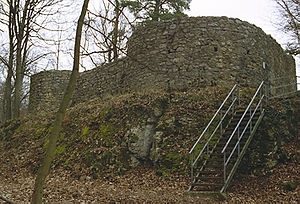
The Alt-Schauenburg ruin is the younger of the two Schauenburg castles west of Frenkendorf in the Swiss canton of Basel-Landschaft.
The ruin is located on the Chleiflüeli, a rock outcrop adjacent to the Schauenburgflue, about 500 meters west of Schauenburg Bad. On the eastern, southern, and northern sides, vertical rock faces form almost insurmountable approach obstacles. The rock outcrop has two vertical fissures that existed before the castle was built (and did not only arise during the Basel earthquake in 1356).
Layout+
The core castle is surrounded on the south, west, and partly also north by a neck ditch, which partly extended existing natural rock formations. The quarrying activity, which as usual also served to obtain building material, is still clearly visible today. Access is at the southwestern corner. The complex is dominated by the up to four-meter-thick shield wall on the west side, which is flanked at the northwestern and southwestern corners by a round corner risalit each.
Behind the shield wall were two living rooms, both of which had ground-level access from the castle courtyard.
In the northeastern corner of the core castle is a rectangular pit carved out of the rock (partially walled), which was used either as a cellar or as a filter cistern.
West of the core castle, traces of an outer bailey – consisting of two wooden houses (possibly farm buildings) – were discovered. However, unlike the core castle, this was only (or initially) very weakly protected by palisades.
According to archaeological finds, the settlement of Alt-Schauenburg began around 1275 to 1280 and was part of the expansion of the Schauenburg clearing zone. This makes Alt-Schauenburg the younger of the two Schauenburg castles.
The use of the castle ended in 1356 with the Basel earthquake. Apparently, the benefits and costs of repairing the damage, especially considering the nearby Neu-Schauenburg, were deemed unfavorable, and so Alt-Schauenburg castle was abandoned, while Neu-Schauenburg was repaired. This led to the misleading naming of Alt- and Neu-Schauenburg: The term "Alt" referred to the state of preservation (old = broken) after the earthquake.
The ruin fell into oblivion, as all goods and rights were apparently linked to Neu-Schauenburg. Only surveys in the years 1949 to 1954 revealed the location of the ruin again. In 1976/77, Alt-Schauenburg was then excavated and restoratively preserved.
Take Mobile History with you
You are reading this text for free. Premium adds what matters on the road: descriptions read aloud, sites found through your camera, whole regions taken offline.
- Every description, including the ~17,700 Premium sites
- Audio guide: have descriptions read to you on location
- AR finder: see sites through your camera, with distance and bearing
- Unlimited saved sites
14 days free, then from €2.99 a month. Cancel anytime.
Source: Wikipedia · Licence: CC BY-SA 4.0
This description draws on the facts documented in the linked Wikipedia article; Wikipedia content is licensed under CC BY-SA 4.0. Wording and editing: Mobile History.
Location: 47.4957, 7.6731