The Roman Castle can be visited
Ancient BuildingUnterböbingen
Roman Castle Unterböbingen
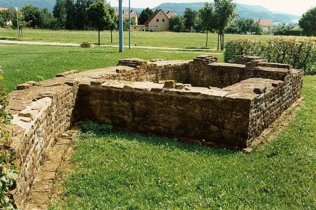
The fort of Unterböbingen is a former Roman fort, which today lies in the east of the municipality of Böbingen an der Rems in the Ostalbkreis in Baden-Württemberg. The cohort fort was built near the south bank of the Rems to secure the nearby Raetian Limes, which was declared a UNESCO World Heritage Site in 2005.
The complex was built on an elevated spur above the south bank of the Rems, skillfully utilizing the terrain. While the terrain rises to around 446 meters above sea level to the southeast, it slopes down to the west into the valley of the Klotzbach, which flows into the Rems river below the fort, flowing here from east to west. From the fort, the Limes running north on the heights above the Rems valley could be partially seen directly, because west of the fortification, the Raetian Wall, coming from the west, descends steeply into the Rems valley without regard for the terrain, then gently bends northeast and climbs back up the heights. In total, the garrison of Unterböbingen could monitor around 20 Limes towers along a stretch of 15 kilometers between Herlikofen in the west and Kolbenberg in the east.
Attested by the field name "Bürgle", the knowledge of an old fortification at this location seems never to have completely vanished. During initial excavations in 1885 and in the autumn of 1886 by the retired Chief of General Staff of the Württemberg army, Eduard von Kallée, Unterböbingen was recognized as a fort site and investigated in 1892 by Major Heinrich Steimle on behalf of the Imperial Limes Commission (RLK). This secured valuable results for the future, as between 1930 and 1935, the Praetentura (front camp), including the large multi-purpose hall belonging to the headquarters building, was destroyed by quarrying to extract gravel for road construction. Since no further investigations could take place in this area before its destruction, many questions remain unanswered.
The remaining parts of the fort were extensively investigated in the spring and summer of 1973 by the State Office for Monument Preservation Baden-Württemberg, Department of Archaeological Heritage, under the direction of Dieter Planck, before extensive overbuilding and the associated loss of this ancient site began. In 1975, during an excavation, larger parts of the civilian settlement with a probable road station were investigated, before historical findings here were also finally destroyed. In 1978, the excavators returned. An area already investigated in 1885/86 and 1892, where a temple stood, had to be re-examined in 1981, as it had been planned by the municipality of Böbingen for the construction of a hall.
The fort was built due to the relocation of the Alblimes to the Rems valley area. As dendrochronological investigations on and near the Limes palisade in the Rotenbachtal near the small fort of Kleindeinbach, as well as in western Schwabsberg, show, the border expansion took place around the mid-160s AD. The troops needed for the palisade construction must therefore have established their camps several years earlier. Unterböbingen was co-administered from the fort of Aalen. Due to the destructions, particularly in the 20th century, significant parts of Böbingen's antiquity have been lost.
Fortifications
The structure was built directly on a natural rock plate, which allowed for some special findings. Clearly distinguishable construction phases could not be determined. The fort was built in an approximate south-north orientation. The praetorial front, i.e., the defensive wall facing the enemy, thus stood in the north and was oriented towards the course of the Limes on the opposite side of the Rems valley. The complex enclosed a rectangular area of 148 × 135 meters (= approx. 2 ha) with its 1.2-meter-wide defensive walls (playing card shape) rounded at the corners. Following the usual structure of its time, it had four gates, each flanked by two gate towers. While the Porta principalis sinistra (here: west gate) and the Porta principalis dextra (here: east gate) each had two passages, only a single-lane access could be found at the rear Porta decumana (here: south gate). Of the Porta praetoria, centrally placed in the praetorial front, only the 4.475-meter-wide east tower remained. The still discernible ground-level tower accesses had a width of 2 meters. At the west gate, the southern gate passage was apparently walled up at some point. A similar finding was also made at the west gate of the fort of Pfünz. Both in the four corners, where a trapezoidal tower stood in each, and in the Retentura, the rear part of the camp, a rectangular tower could be identified on both the western and eastern long sides. All towers had been built leaning against the wall. Herringbone masonry (Opus spicatum) was found on the southeastern corner tower and the eastern intermediate tower. It is debated whether rectangular foundations on the fort wall could have been artillery towers. This includes a square of masonry in Unterböbingen, built directly next to the northwest tower on the praetorial front. As a special feature, at least three eight-meter-wide pointed ditches, which surrounded the camp as an approach obstacle, were cut into the bedrock.
Internal Buildings
At the intersection of the two main fort axes, inside the complex, where the two main camp roads Via principalis and Via praetoria crossed, was the large, 57.40 × 16 meter multi-purpose hall of the barracks, lying transversely across the Via Principalis, with the rooms of the Principia, the headquarters building, adjoining behind it in a square. The service and administrative rooms of this building were arranged around a rectangular, colonnaded courtyard. The rear rooms, at least three of which were heated, lay to the right and left of the flag sanctuary (Aedes principiorum) centrally located in the Principia. With its semicircular apse, the sanctuary protruded from the rear wall of the headquarters building. The design of the sanctuary with semicircular apses only became common in the forts of the Germanic provinces from the mid-2nd century. Built to the west of the headquarters building and following its long side, the Horreum, the granary, was excavated, its floors resting on stone pillars. To the east was the Praetorium, the living quarters of the camp commander, which was only partially built in timber. Those rooms that were heated were constructed in stone. The rooms standing on a massive foundation are apparently to be interpreted as the house's bath. Two of the rooms were heated, the eastern area with an apse could be interpreted as a cold bath (Frigidarium). Since stone robbing was very intensive, some findings could not be clearly identified. Research was able to locate another stone building, which was in the eastern part of the Praetentura, the rear camp area. The actual attribution of this structure, known as "Baracke" (barracks), remains unknown, however, as it was destroyed in the 1930s during quarrying. The RLK was able to identify remains of burnt timber structures under the "Baracke". In the Retentura, an underground drainage channel (Cloaca) cut into the bedrock was uncovered along the Via sagularis (camp ring road), which drained south of the southeastern corner tower into the innermost pointed ditch. This channel contained important small finds. Researchers concluded, based on a layer of burning in the area of the Horreum and Principia, that Unterböbingen met a violent end.
Finds
Among other finds from the fort area in 1973, fibulae, coins, a silver spoon, the gilded letter of an inscription, military belt fittings decorated with openwork technique, parts of horse harnesses, and the bronze thumb of a larger-than-life armored statue, probably depicting an emperor, are worth mentioning. From the Praetentura comes a fragment of a bronze military diploma, which, however, can no longer be precisely dated. Nevertheless, research places it in the first half of the 2nd century AD.
A four-inch high Roman bronze figure was found in the fort in the past but has long been considered lost. Today, an excellently preserved bronze Jupiter statuette, found in 1926, is among the significant finds. The 11.8-centimeter-high figure was recovered from the gravel of the Rems eleven kilometers below Unterböbingen. Whether Jupiter also comes from the fort, or like the Mars recovered in 1962 (see below) is to be assigned to the camp village, remains unknown.
Fort Bath+
The military bath (Balineum), which was also available to the inhabitants of the village, was identified in 1978 north of the fort on a high terrace at the edge of the Rems valley. A well-preserved bronze yoke attachment was found in its rubble.
Vicus, Mansio and Temple+
The Vicus, the civilian camp village, extended south, southeast, and east of the garrison. In 1975, residential houses were investigated 80 meters east of the fort, of which a larger group of buildings with four mostly elongated, rectangular structures may have been a Mansio, an inn with lodging and outbuildings, which offered accommodation to travelers south of the ancient road to Aalen. Almost all rooms were hypocausted, had glass windows, and were separated from each other by long courtyard walls. A bread oven was uncovered at one of the houses. From the wall thickness of the foundations, the excavators concluded that the rising walls had been built in half-timbered construction. Unusual among the finds were numerous glass vessels and bricks reused in construction, whose stamps came from the Cohors I Ratorum located in the fort of Schirenhof.
Around 100 meters southeast of the southeastern corner of the fort, excavations took place in 1885/86, 1892, and most recently, before the overbuilding of the area, in 1981. A multitude of post holes and pits were uncovered, which were most likely once part of the early village. Remarkable was a rectangular, 13-meter-long and 9.4-meter-wide large building erected above it, with a rectangular apse, 4.8 × 2 meters deep, centrally located in the eastern rear wall. Due to stone robbing, only the lowest foundation courses of the building had survived. In front of the main entrance, on the western end wall, there was a portico built in timber, of which the four post holes of the supporting beams had survived. According to the findings, this portico formed a 2 × 9.4 meter vestibule. Due to the poor state of preservation, the western main entrance, located in the middle of the building, could only be localized by a post hole and a rectangularly hewn sandstone. On the south wall of the building was an attached, heated, 4.4 × 5 meter ancillary room, which was in line with the main facade. In a second construction phase, this room was extended three meters to the east, so that the room, still heated from the east, was now 7 × 5 meters in size.
The excavators agree on the cultic background of this building, especially since there are other architecturally identical temple findings from the Germanic and British provinces. The most important of the numerous finds from this temple are glass vials covered with threads, a silver spoon, weapons, a bronze plate on which the human foot of a statuette had survived, and the head of a female stone sculpture, which came out of the ground outside the temple in 1981 during leveling work. Through the analysis of the find material, the building could be dated to the 2nd half of the 2nd century.
Among the other finds from the camp village, a completely preserved bronze statuette of a naked, helmeted war god Mars, recovered in 1962 about 110 meters southeast of the Porta decumana and becoming known nationwide, is particularly noteworthy. The 19.4-centimeter-high figurine is dated to the 2nd/3rd century AD. Along with Mars, other iron objects also came out of the ground.
During construction work, some undocumented cremation graves apparently came to light west of the fort on the eastern slope of the Schlierbach. However, the actual cremation cemetery belonging to the settlement and fort has not yet been discovered.
Troop+
The cohort that once occupied the garrison remains unknown due to a lack of written evidence on site, but based on the size of the camp, it was a cohort of regular auxiliary troops, approximately 500 men strong. Nuber suspected the Cohors VI Lusitanorum, which, however, cannot be proven to this day. Whether the troop stationed in Unterböbingen was a pure infantry unit or, which is more likely in comparison with other Limes forts, a partially mounted cohort, remains open. It was suspected that this unknown unit was previously based in the fort of Urspring. Urspring was built to fortify the Alblimes and was abandoned after the border was moved to the Rems valley area.
The fragment of a military diploma, still 41 mm high and 34 mm wide, found in the northeastern Praetentura near a barracks, 28 m behind the north front, provides no information about the troop in its preserved state:
Stro[bilo ?
Descri]pt(um) et recog[nit (um) ex tabula aenea, quae f]ix(a) est Rom(ae) in [muro post templum divi] Aug(usti) [ad Minervam].
Translation:
Strobilus (?) ... Checked and certified according to the bronze tablet, which is affixed in Rome on the wall behind the temple of the deified Augustus near the temple of Minerva.
Strobilus was the name of the soldier who received the diploma, probably after 134 AD, upon his discharge from the Roman army after 25 years of service.
Location of Finds+
Many finds from the fort and vicus, such as the military diploma, are now in the Landesmuseum Württemberg and the Limesmuseum Aalen.
The Jupiter statuette can be viewed in the "Museum im Prediger" in Schwäbisch Gmünd.
Take Mobile History with you
You are reading this text for free. Premium adds what matters on the road: descriptions read aloud, sites found through your camera, whole regions taken offline.
- Every description, including the ~17,700 Premium sites
- Audio guide: have descriptions read to you on location
- AR finder: see sites through your camera, with distance and bearing
- Unlimited saved sites
14 days free, then from €2.99 a month. Cancel anytime.
Source: Wikipedia · Licence: CC BY-SA 4.0
This description draws on the facts documented in the linked Wikipedia article; Wikipedia content is licensed under CC BY-SA 4.0. Wording and editing: Mobile History.
Location: 48.8189, 9.9247