The Roman Castle can be visited
Ancient BuildingWelzheim
Roman Castle Rötelsee
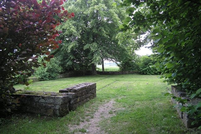
The small fort of Rötelsee is a former Roman fortification of the Upper Germanic Limes, which gained UNESCO World Heritage status in 2005. The small fort was built about 40 meters from the Roman imperial border and is now located in the municipal area of Welzheim, a town in the Rems-Murr district in Baden-Württemberg. Rötelsee has entered the typology of provincial Roman research. The name is now used for all similarly structured installations on the Roman imperial border. Also outstanding was the discovery of coins from the time of Emperor Gallienus (253–260), which place the demise of the fortification in the late period of the Limes fall.
The small fort, built on a hill about 1.5 km north of the western fort of Welzheim, is located on an 80 km long stretch of the Limes running almost exactly in a north-south direction. Already the Imperial Limes Commission (RLK) under Gustav Sixt (1856–1904) investigated the defensive walls of the complex, located in the Ländlesäcker area, in 1895, which was built about 40 m behind the Roman border installations. But it was only the excavation by the State Office for Monument Preservation Baden-Württemberg in autumn 1974, carried out as part of the land consolidation and under the direction of archaeologist Dieter Planck, that brought complete clarity about the ground plan of this small stone fortification. This was the first time that the smallest form of this variant of a border garrison was extensively investigated on the Upper Germanic-Rhaetian Limes. After the excavation, the small fort was visibly preserved for the public by the Schorndorf Land Consolidation Office and the city of Welzheim.
The excellent choice of location on a commanding hill allowed for very good control of the wide Limes foreland and the wooden palisade running north with its towers. Based on small finds, primarily pottery, it is assumed that this outpost, occupied by ten to twenty soldiers, was probably only built in the late 2nd century. Perhaps its timing also belongs to that last phase of the Limes expansion, in which the small fort "In der Harlach" was also built. In contrast to this, Rötelsee, like most small forts, does not have a flag sanctuary. Therefore, a detached unit, probably from Welzheim, is assumed to be the troop. The striking proximity of the two forts there could allow this conclusion. Also noteworthy is the similarity in size and ground plan to the small fort of Ebnisee, located 4.5 km north, and the small fort of Hankertsmühle, discovered near Murrhardt.
The 18.5 × 18.5 m (= 324 m²) square small fort is surrounded by a pointed ditch up to 2 m wide, which is interrupted at the single-lane access. The encompassing defensive walls are about 1 m wide. The gate has no tower, but rather re-entrant tongue walls, as were also observed at entrances of the older eastern fort of Welzheim, built around 115 or 140 AD.
At the two points where the ditch was interrupted in front of the access, the excavators found one pit each. It is suspected that these were the remains of a possible barricade. On the inside of the wall, post holes were uncovered all around, which belonged to a former battlement. The wooden interior buildings are grouped in a square to the south, north, and west around a paved courtyard in the center of the fort and are only interrupted in the east, where the entrance and the praetorial front facing the Limes are located. The courtyard had a porticus, a covered walkway. On its western end, located under the porticus, a large hearth was uncovered. The investigation of the interior buildings, constructed in sill-beam technique, showed that there were two or three almost equally sized rooms. In the southeast corner, a drainage channel leading from the courtyard was uncovered, which extended through the defensive wall to the ditch.
Rötelsee is believed to have existed until the abandonment of the Limes after the middle of the 3rd century. Small forts, along with the towers, were essential strongholds for the Roman troops directly behind the Limes. Their use, however, is generally unknown. It is assumed that the unknown unit of the small fort of Rötelsee was responsible for monitoring a section of the Limes.
Among the finds recovered were a fibula, a phallus-shaped pendant, and coins. One of these coins dated back to republican times and was minted as a denarius of the 11th Legion by Marcus Antonius, who wanted to win the troops over with this money. In addition, the youngest coins of the Anterior Limes were discovered in Rötelsee and at the small fort of Haselburg. They originated during the reign of Emperor Gallienus (253–260). The archaeologist and Limes expert Egon Schallmayer reported that Gallienus' Antoninian from Haselburg was minted no earlier than 259.
In the course of the Limes fall, which culminated in the abandonment of the Agri decumates (Decumate Lands) in 259/260 AD, the still existing Roman border installations were evacuated by the troops, if they had not already been violently destroyed.
On Function and Dating+
Planck summarized a number of small forts on the Upper Germanic Limes, similar in size, construction, and distance from the border wall, under the designation "field outposts of the Rötelsee type." Based on datable finds in the installations he investigated, he assumes that this type probably only emerged in the late 2nd century. The archaeologist Andreas Thiel dates this fort type even younger, to the late Limes period. The reduction of troops at this time led to a reorganization of border surveillance. The constantly occupied tower positions were now replaced by small forts of this type to manage border surveillance with a troop strength that would no longer have been sufficient to occupy the tower positions.
Take Mobile History with you
You are reading this text for free. Premium adds what matters on the road: descriptions read aloud, sites found through your camera, whole regions taken offline.
- Every description, including the ~17,700 Premium sites
- Audio guide: have descriptions read to you on location
- AR finder: see sites through your camera, with distance and bearing
- Unlimited saved sites
14 days free, then from €2.99 a month. Cancel anytime.
Source: Wikipedia · Licence: CC BY-SA 4.0
This description draws on the facts documented in the linked Wikipedia article; Wikipedia content is licensed under CC BY-SA 4.0. Wording and editing: Mobile History.
Location: 48.8866, 9.6338