The Roman Castle can be visited
Ancient BuildingRosbach
Roman Castle Kapersburg (Rosbach)
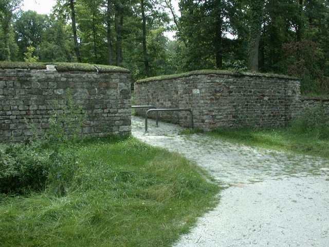
The former Roman Limes fort Kapersburg in the Taunus is one of the best-preserved Roman military installations of the Upper Germanic-Rhaetian Limes. It housed the Numerus Nidensium, an auxiliary troop recruited from inhabitants of the nearby Vicus Nida. The construction history of the fort shows several construction and renovation phases since the end of the 1st century, as well as traces of a fort vicus. The fort was probably evacuated without a fight shortly after the middle of the 3rd century as part of the Limes Fall.
Kapersburg fort is located a good 2 km southwest of the Steinkopf on the western border of the Wetteraukreis with the Hochtaunuskreis. At a distance of two and a half and three and a half kilometers, it is relatively remote from the nearest villages of Pfaffenwiesbach, a district of the municipality of Wehrheim, and Ober-Rosbach, a district of the town of Rosbach vor der Höhe. The area of the Taunus where the fort is located was already used for forestry in Roman times.
Kapersburg fort was probably built in Trajanic times, i.e., from 98 AD, but perhaps not until around 130 AD. A possible predecessor was the small fort Ockstädter Wald (see below). The end of the complex is also not clearly ascertainable. Around the middle of the 3rd century, part of the garrison was probably withdrawn, as a dismantling of the fort facilities is demonstrable for this period: the remaining garrison retreated to the northeastern quarter of the complex around the granary, and the outer rampart fell into disrepair. In place of the former hall of the Principia, a small, square, and heated stone building was erected, presumably the centurion's quarters. To enclose the still-used section of the fort, a wall was built between this stone building and the north gate. The fort met its end during the internal and external political and economic crisis of the empire around the middle of the 3rd century (Limes Fall). However, no traces of violent destruction can be found. The coin series shows an Antoninian of Postumus as the final coin, and another Antoninian of Gallienus (minted 255/56 AD) was found in the northern tower of the east gate.
Complex+
Research
Kapersburg fort was first mentioned in a document as Karpesserburgk in 1482. The origin of the name is not certain. In the 19th century and again in the 1940s, there were some explanatory approaches, but none of them prevailed.
The first archaeological investigations took place from 1879 to 1881, and systematic scientific research was carried out in 1896/97, 1901, and 1905 by the Imperial Limes Commission. Further excavation and conservation work followed between 1906 and 1914. Most recently, the fort was completely restored in 2005 in connection with the recognition of the Upper Germanic-Rhaetian Limes as a World Heritage Site, and the entire fort area was converted into an Archaeological Park.
Fort
During the investigations, a total of three construction phases could be identified:
- Wood-earth fort of approximately 0.8 hectares, built at the end of the 1st century AD.
- Fort with dry stone walling of about 1.3 hectares, built around the middle of the 2nd century (late Hadrianic or Antonine).
- Fort with mortar wall of a good 1.6 hectares, which replaced the previous structure towards the end of the 2nd century.
The visible wall lines today are those of the last expansion phase.
The camp, measuring 134 x 122 meters and covering a good 1.6 hectares in this phase, has a rectangular layout with rounded corners and four gates.
The fort corners are rounded, with the northwest corner being the only one fortified with a tower. The entire enclosure is surrounded by a simple pointed ditch. The fort, with its Porta praetoria (main gate), is not oriented directly towards the Limes, which passes Kapersburg at a distance of about 60 meters to the west, but rather to the north towards the small fort Ockstädter Wald. Except for the Porta decumana (rear gate), all gates are equipped with double towers.
The north-south axis of the camp is asymmetrically shifted to the west, which was caused by the fact that the fort extensions were oriented towards the Via praetoria and the Via principalis of the older, smaller predecessor buildings, meaning the camp essentially grew unilaterally to the southeast.
In the similarly shifted center were the Principia (headquarters building), of which only the foundations of the shrine of the standards (Aedes) and some writing rooms on the southern edge of the building are still visible. In addition, the Principia had a hall that extended over the Via principalis, and some ancillary buildings, including the armory. The Principia were originally constructed in half-timbered style, the stone foundations present today date from a later expansion phase. In the late phase of the fort, the northern and eastern sections were demolished and built over. However, the shrine of the standards seems to have been used until the end of the fort, as shown by the discovery of a Genius statue from the 3rd century. Further walls are found in the northeastern quarter of the fort interior; these are the remains of the Horreum (granary) and the Praetorium (commander's residence). The Horreum, visible in remnants today, was built in 208 or 209 over the demolished original Praetorium. Other wall remains in this area probably belong to the commander's bath. All other interior buildings are likely to have been half-timbered and are no longer visible today.
A Numerus Nidensium could be identified as the garrison of Kapersburg.
Fort Bath and Vicus
Between the fort and the Limes are the very well-preserved foundations of the fort bath, built at the latest in the middle of the second century, which represents a fine example of the Romans' single-axis thermal architecture (so-called row type). The Apodyterium (changing room) was probably made of half-timbering and is no longer preserved. The structures of all other rooms (a Frigidarium (cold bath), two Tepidaria (warm baths), a Caldarium (hot bath), and a Sudatorium (sweat bath) are preserved, so that visitors can easily understand the layout of such a balneum. The individual sections were aligned with the west gate of the fort in the logical sequence of the bathing process. The energy supply for the bathing complex was provided by three Praefurnia (firing points); all rooms except the Apodyterium and the Frigidarium were heated by hypocausts. The water supply was ensured by a nearby, still existing spring.
The extensive area of a Vicus (camp village) and a cemetery could be located around the fort, but their full dimensions could not be recorded. The Vicus is mainly located on the eastern side of the camp, facing the Saukopf mountain. The remains are only recognizable with a trained eye.
Surroundings+
In Roman times, Kapersburg fort could be reached via the Limesweg, via Köppern, and via Ober-Rosbach from the Civitas Taunensium. Traffic over the Taunus ridge into the Usingen Basin, which has been relatively densely populated since the Linear Pottery culture, could be controlled here. The old trade route from the southeast still bears the name "Hühnerpfad" (in Köppern "Im Hahnereck"), which could indicate a pre-Roman use of this path.
To the north of the well-preserved Limes course in this area, following Kapersburg fort, there are also two former small forts and a reconstructed stone watchtower. These are the small forts Ockstädter Wald and Kaisergrube, as well as the watch post Auf dem Gaulskopf.
The small fort Ockstädter Wald, located only 700 meters north of Kapersburg, was a single-gated wooden fort of about 0.2 hectares from a very early construction phase of the Limes. The gate of the camp, surrounded by a simple ditch, was oriented away from the Limes to the southeast. The small fort Ockstädter Wald was only in use for a short period; possibly the unit that later built Kapersburg was stationed here. After the abandonment of the fort, a watchtower was built here, which is counted as Wp 4/11. A total of one wooden and two stone construction phases of this watchtower could be identified. The second stone tower site has a hexagonal plan, possibly indicating a very rare hexagonal stone tower. The traces of these structures are still clearly visible as terrain deformations (wooden tower site) and as rubble heaps of the stone tower sites.
About two kilometers further was the small fort Kaisergrube, a camp of only about 730 square meters, where one wooden and one stone construction phase could be identified. The fort has been damaged by a nearby modern mine, but is still clearly visible in the terrain.
Finally, on the following northern height, is the stone watchtower on the Gaulskopf (Wp4/16), reconstructed in 1926. Here, the remains of a particularly tall and impressive Limes watchtower were found and restored. The impressive tower, from which one can enjoy an excellent view, is considered one of the best-reconstructed watchtowers of the entire Limes. However, the ancient original tower was certainly plastered and was probably a little taller.
Take Mobile History with you
You are reading this text for free. Premium adds what matters on the road: descriptions read aloud, sites found through your camera, whole regions taken offline.
- Every description, including the ~17,700 Premium sites
- Audio guide: have descriptions read to you on location
- AR finder: see sites through your camera, with distance and bearing
- Unlimited saved sites
14 days free, then from €2.99 a month. Cancel anytime.
Source: Wikipedia · Licence: CC BY-SA 4.0
This description draws on the facts documented in the linked Wikipedia article; Wikipedia content is licensed under CC BY-SA 4.0. Wording and editing: Mobile History.
Location: 50.3130, 8.6357