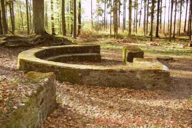
The remains of the roman Castle can be visited
Ancient BuildingHolzhausen an der Haide
Roman Castle Holzhausen
Kastell Holzhausen is a former Roman frontier fort of the Upper Germanic Limes, which has held UNESCO World Heritage status since 2005. The former cohort fort is now an archaeological monument in the forests of Holzhausen an der Haide (Verbandsgemeinde Nastätten), a local municipality in the Rhineland-Palatinate Rhein-Lahn-Kreis. It is considered one of the best-preserved Limes forts in Germany.
In today's topography, the archaeological monument is located north of Federal Highway 260, the so-called "Bäderstraße Taunus," between Holzhausen an der Haide (Rhineland-Palatinate) and Laufenselden (Hesse) in an extensive forest area. There it lies at an average altitude of 495 meters on the northwestern slope of the Grauer Kopf, the second-highest mountain in the western Hintertaunus at 543.4 m above sea level.
Along the course of the Limes, the Holzhausen fortification is the southernmost and last fort in the state of Rhineland-Palatinate. The border with Hesse runs only about 120 m to the northeast. Even the next watchtower (Wp 2/35) is on Hessian territory.
Research History+
Thanks to their secluded location, the ruins of the fort remained untouched for a long time. It was only in connection with the construction of the so-called Bäderstraße at the beginning of the 19th century that extensive damage occurred, as the fort walls were used as a cheap quarry for the construction of the road. A first detailed description of the fort site appeared in 1859 in the Nassauische Annalen. More extensive archaeological investigations were then carried out by Karl August von Cohausen in 1874 and 1882, before large-scale excavations were finally undertaken by the Reichs-Limes-Kommission (RLK) under the direction of section commissioner Ludwig Pallat between 1897 and 1903. The last scientific excavations to date were carried out by Karl Nass in 1932.
Findings+
Fort
Kastell Holzhausen is one of the smallest garrisons of the Upper Germanic Limes. With its dimensions of 135.4 m by 105.6 m, it covered an area of just over 1.4 hectares. With its praetorial front, it was – deviating from the standard – not oriented towards the Limes, which passed the fort at a distance of 70 m to 100 m to the northwest, but to the northeast. This circumstance may be due to the topographical conditions on the slope of the "Grauer Kopf," which necessitated such an alignment if too steep a gradient within the fort area was to be avoided. Even so, the difference in height between the Porta principalis dextra (right side gate) and the Porta principalis sinistra (left side gate) is still considerable at more than nine meters. The extension of the Via praetoria led to a Limes crossing at a distance of approximately 350 m.
The defensive wall had a thickness of 1.50 m, the foundation was 90 cm deep and 1.50 m to 1.65 m wide. It was constructed with the local greywacke on the outside in regular, almost horizontal masonry, while on the inside the stones were set less carefully and more irregularly using large quantities of lime mortar. On the outside, the fort wall was plastered yellowish-white and provided with irregularly running, red false joints. In front of the wall ran a pointed ditch, which only ceased in front of the Porta principalis sinistra, which was oriented towards the Limes. It had a width of 5.50 m to 6.00 m and reached a maximum depth of 2.00 m (next to the Porta decumana) with an average of 1.40 m to 1.60 m. Separated from the wall, the ditch was by a berm of varying width, which differed between 1.50 m and 2.00 m along the wall and 1.00 m and 3.50 m at the gates. On the inside of the camp, an earth rampart, 9.50 m to 10.50 m wide at its base, supported the rampart walk.
The rampart was provided with gates on all four sides. The gate at the praetorial front was the largest, with a width of 8.40 m. It was designed as a double gate with a central pillar. According to the excavation findings, a bridge probably led over the ditch, which was not interrupted in front of this gate. The rounded corners of the defensive wall were occupied by towers. In the towers there were (proven in three, reconstructed in the north corner) installations, which were interpreted as constructions for – possibly rotatable – artillery emplacements.
Of the interior buildings, mainly parts of the Principia (headquarters building) could be uncovered. Especially in the rear part of the Principia, the foundations of the apse-shaped, un-basemented flag sanctuary (Sacellum or Aedes) were still preserved up to one meter in height. Of the service and meeting rooms located to the right and left of the flag sanctuary, at least one (the north-western one) was provided with a hypocaust. The other interior buildings were probably constructed of wood or half-timbering and could not be recorded with the excavation methods at the time of the Reichs-Limes-Kommission. It was only during the 1932 excavation that three more buildings in the northwest of the Principia were identified, one of which was interpreted as a barracks.
Fort Bath
The baths could be located northwest of the fort, between it and the Limes, not far from the source of the Hasenbach, which presumably supplied the baths with water. They were investigated in 1882 by Cohausen and later by the Commission, but in both cases could not be systematically excavated due to a lack of necessary funds. While the RLK only investigated the course of the outer wall facing the fort, Cohausen had at least been able to examine part of the building complex more closely. The architectural form with apses found there, as well as the high number of finds of tegulae (tiles), suggest that this part of the building could have been the Caldarium (warm bath) and the Tepidarium (lukewarm bath).
Vicus
Also for financial reasons, the Vicus, the civilian settlement found at every larger Roman garrison, could not be investigated in more detail either during the 1882 campaign or during the imperial excavations. Nevertheless, traces of non-military settlement were found in front of the Porta praetoria, in front of the Porta principalis dextra, and in front of the Porta decumana. The terrain deformations in the forest suggest further expected but not yet excavated findings.
Dating and Garrison+
According to current views, the Holzhausen fort was built under Commodus, probably at the same time as Kastell Niederbieber around the years 185/190. The coin finds do not support this initial dating, as their initial maximum is only around 220 AD. Coins of Septimius Severus are strongly underrepresented. The latest dating is the year 213 AD, based on the honorary inscription for Emperor Caracalla.
It was garrisoned by the Cohors II Treverorum ("2nd Cohort of the Treveri"), a sister unit of the Cohors I Treverorum stationed at Kastell Zugmantel, which is attested by numerous inscriptions. Over time, this pure infantry unit adopted various epithets. At the beginning of the third century, it called itself Cohors II Antoniniana Treverorum after the reigning emperor Caracalla, but a few years later changed its name to Cohors II Severiana Treverorum. This name also referred to the reigning Princeps, this time Severus Alexander. The fort existed until the abandonment of the Limes in the years 259/260.
Miscellaneous+
In the area of the fort, there is a presence of Lesser Periwinkle. As with numerous other Roman fort buildings, it can be attributed to a Roman-era planting.
Take Mobile History with you
You are reading this text for free. Premium adds what matters on the road: descriptions read aloud, sites found through your camera, whole regions taken offline.
- Every description, including the ~17,700 Premium sites
- Audio guide: have descriptions read to you on location
- AR finder: see sites through your camera, with distance and bearing
- Unlimited saved sites
14 days free, then from €2.99 a month. Cancel anytime.
Source: Wikipedia · Licence: CC BY-SA 4.0 · Image: http://de.wikipedia.org/wiki/Datei:Holzhausen_an_der_Haide_Roemerkastell.jpg
This description draws on the facts documented in the linked Wikipedia article; Wikipedia content is licensed under CC BY-SA 4.0. Wording and editing: Mobile History.
Location: 50.2149, 7.9475