The remains of the roman Castle can be visited
Ancient BuildingHillscheid
Roman Castle Hillscheid
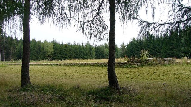
The small fort of Hillscheid is a former Roman fort of the Upper Germanic Limes, which achieved UNESCO World Heritage status in 2005. The archaeological monument, partially preserved and reconstructed in its foundations, is located in the forests northeast of the present-day municipality of Hillscheid, which belongs to the Westerwald district in Rhineland-Palatinate.
The small fortification is located a good kilometer as the crow flies from Hillscheid in the Hillscheid Forest, on the high terrace of an offshoot of the Montabaur Heights extending to the southwest.
In Roman times, it was located about 22 meters behind the Limes wall at a point where two ancient roads ascending from the Rhine plain to the heights of the Westerwald converged and crossed the Limes. One of these roads came from the southwest, from the nearest larger garrison, the Niederberg fort, the second led from the Vallendar area.
Research History+
As late as 1833, the Limes and Roman road researcher Friedrich Wilhelm Schmidt noted well-preserved ramparts and ditches, as well as a not inconsiderable height of standing masonry of the defensive structure in the Hillscheid Forest. Already in 1857, Carl August von Cohausen had to state that only small parts of the complex were still visible. The stones of the masonry had in the meantime been broken out for road construction and the area largely leveled. Subsequently, treasure hunters completed the work of destruction, so that the Imperial Limes Commission was confronted with heavily disturbed findings when it began its investigations. The archaeological excavations of the commission were carried out in the spring of 1894 under the local direction of district commissioner Otto Dahm.
After a break of over a hundred years, new investigations were carried out in 1999 by the "Archaeological Heritage Conservation, Koblenz Office". Finally, in the spring of 2003, the foundations of the fort and the neighboring watchtower Wp 1/71 were preserved and partially reconstructed by the municipality of Hillscheid.
Findings+
The small fort of Hillscheid is a double complex, consisting of a larger outer fort and a smaller inner fort. The high degree of destruction of the findings caused considerable difficulties for a secure interpretation from the beginning of the investigations. The documentation of the findings by the Imperial Limes Commission must also be viewed with certain reservations against this background.
The larger complex, with its side lengths of 43.10 by 36.60 meters, occupies an area of just under 0.16 hectares; the wall thickness averaged 1.20 meters. According to current knowledge, the wall, rounded at its corners, was not equipped with defensive towers. A berm of about six to eight meters wide separated it from a ditch with a preserved residual depth of 70 to 100 centimeters.
Traces of internal buildings could not be detected. The troops may have been housed in tents.
The defensive structure located within the outlines of the larger fort was probably built at a later date. With its side lengths of 15.90 by 15.40 meters, it had an almost square ground plan and occupied an area of only just over 0.025 hectares. The defensive wall, also rounded at its corners, had a thickness of 1.20 meters. The only gate, about 2.50 meters wide, faced northwest. Towards the outer fort, the smaller defensive structure was delimited by a ditch. In its southern corner was a perhaps two- to three-story, tower-like building with an inner usable area of around 25.5 square meters. A presumably single-story antechamber with an inner area of just over 5.5 square meters was attached to its northeast side. The wall thickness of both structures was 100 centimeters.
Approximately halfway between the fort and the Limes was watchtower Wp 1/71, which, like the fort, was reconstructed in its foundations.
Nothing precise is known about the garrison of Hillscheid. It was probably a vexillatio (detachment) of a larger and nearby auxiliary unit. The Niederberg fort is a possible location for the parent unit.
Take Mobile History with you
You are reading this text for free. Premium adds what matters on the road: descriptions read aloud, sites found through your camera, whole regions taken offline.
- Every description, including the ~17,700 Premium sites
- Audio guide: have descriptions read to you on location
- AR finder: see sites through your camera, with distance and bearing
- Unlimited saved sites
14 days free, then from €2.99 a month. Cancel anytime.
Source: Wikipedia · Licence: CC BY-SA 4.0 · Image: http://de.wikipedia.org/wiki/Datei:Hillscheid_4.jpg
This description draws on the facts documented in the linked Wikipedia article; Wikipedia content is licensed under CC BY-SA 4.0. Wording and editing: Mobile History.
Location: 50.4108, 7.7100