The Roman Castle can be visited
Ancient BuildingSchwäbisch Gmünd
Roman Castle Freimühle
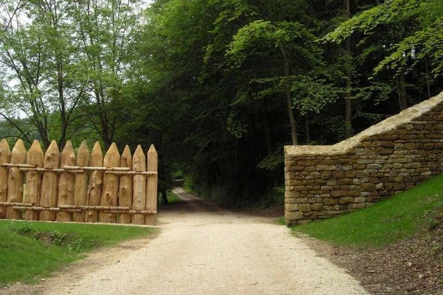
The small fort of Freimühle was a Roman fortification of the Raetian Limes, which gained UNESCO World Heritage status in 2005. The small fort was built approximately 750 meters south of the Roman imperial border. The remains are located northwest of Schwäbisch Gmünd in the Ostalbkreis district in Baden-Württemberg.
The small fort of Freimühle was situated on a slightly protruding spur of the eastern slope of the Rotenbachtal valley in the Vogelhau forest area. From there, both the Rotenbachtal and a section of the Remstal could be observed. Only 750 meters to the north, an unusually far distance for a small fort, the west-east oriented palisade of the Upper Germanic Limes, apparently built in 164 AD, descended into the Rotenbachtal. On this slope, about 90 meters west above the Rotenbach, the stone section of the Limes began at the border of the Roman provinces of Germania superior (Upper Germania) and Raetia (Raetia), extending to the Danube. From the small fort of Freimühle, both the small fort of Kleindeinbach, located about one kilometer northwest on the western slope of the Rotenbachtal, and the watchtower above this fortification could be seen. The unit stationed there could also keep an eye on another section of the Remstal.
Research History+
Until its discovery in 1901, neither popular tradition nor field names suggested a fort in Vogelhau. It was only a hurricane-force storm sweeping across the land at the time, uprooting several trees, that revealed wall remains, which forest officials discovered while clearing the windthrow. The mayor of Schwäbisch Gmünd, Paul Möhler, initiated excavations, which very soon brought to light foundation remains of a Roman building. Major Heinrich Steimle, section commissioner of the Imperial Limes Commission (RLK), subsequently investigated the enclosure and interior of the complex in 1902 and recognized the wall remains as a fort.
With the elevation of the Limes to World Heritage status in 2005, the fort site was geomagnetically and geoelectrically prospected, the forest on the fort area was cleared, and the rampart was clearly raised. No excavations took place, but the site was newly documented. In 2006, Dieter Planck, then president of the State Office for Monument Preservation Baden-Württemberg, inaugurated this complex. An information pavilion was opened directly below the ancient fortification in May 2009. Approximately 800 meters south of the Limes course, a reconstruction attempt illustrates the meeting of the Upper Germanic palisade with a ditch and the Raetian Limes wall.
Construction History+
The 53 × 55 meter (= 0.29 ha) complex, with its 1.2 meter wide enclosing wall, fronted by a 6 meter wide V-shaped ditch, most likely had an interior built of wood. The search for this construction proved fruitless for the RLK, possibly due to the less advanced excavation techniques at the time. However, it was determined that behind the stone defensive wall there was an earthen rampart on which the guard soldiers patrolled.
The fort was built in an almost identical alignment to the cohort fort of Schirenhof on the opposite side of the Rems. In 1902, a single-lane gate, flanked by two towers each, was identified in the west and east, and a trapezoidal corner tower was uncovered. In total, the fortification had four corner towers.
It is assumed that the small fort of Freimühle could have belonged to the type of small fort of Haselburg near Walldürn. Due to its location, scholars are unclear about the significance of this fortification, situated about 100 meters below the Limes and exactly between Schirenhof and the small fort of Kleindeinbach. Dieter Planck expressed the opinion: "...that this small fort was built to monitor the presumed border demarcation here. Presumably, the troops stationed here were subordinate to the fort of Schirenhof, with which there was a direct line of sight."
Perhaps the troops stationed in Freimühle were only secondarily involved in the Limes defense. Southwest of the small fort, Roman settlement remains and graves were discovered at the valley floor where the Rotenbach emerges from the Rotenbachtal during road and railway bridge construction work. This perhaps indicates the possible independence of a unit stationed here for a longer period. It was therefore suspected that the small fort of Freimühle might have been a base for the Roman road police, who had to monitor the long-distance road in the Remstal, which also crossed the border between the provinces of Germania superior and Raetia near the mouth of the Rotenbach into the Rems.
The border area of Germania superior and Raetia is unusually densely populated with Roman military bases in the Limes area. The proximity of the cohort forts of Lorch on the edge of the province of Germania superior and Schirenhof in Raetia also seems to confirm this impression. Perhaps a certain independent action by those responsible for provincial administration becomes visible here. Especially the expansion of the imperial border in stone, carried out only in Raetia, could be evidence for this.
Fort Bath+
Approximately 50 meters southwest of the small fortification, a small fort bath was discovered, which today appears as a faint unevenness in the landscape. The proof of such a thermal bath shows that even with these small complexes, a remarkably developed infrastructure can be expected.
Take Mobile History with you
You are reading this text for free. Premium adds what matters on the road: descriptions read aloud, sites found through your camera, whole regions taken offline.
- Every description, including the ~17,700 Premium sites
- Audio guide: have descriptions read to you on location
- AR finder: see sites through your camera, with distance and bearing
- Unlimited saved sites
14 days free, then from €2.99 a month. Cancel anytime.
Source: Wikipedia · Licence: CC BY-SA 4.0
This description draws on the facts documented in the linked Wikipedia article; Wikipedia content is licensed under CC BY-SA 4.0. Wording and editing: Mobile History.
Location: 48.7915, 9.7637