The Roman Castle can be visited
Ancient BuildingKellmünz
Roman Castle CAELIVS MONS (Caelius Mons)
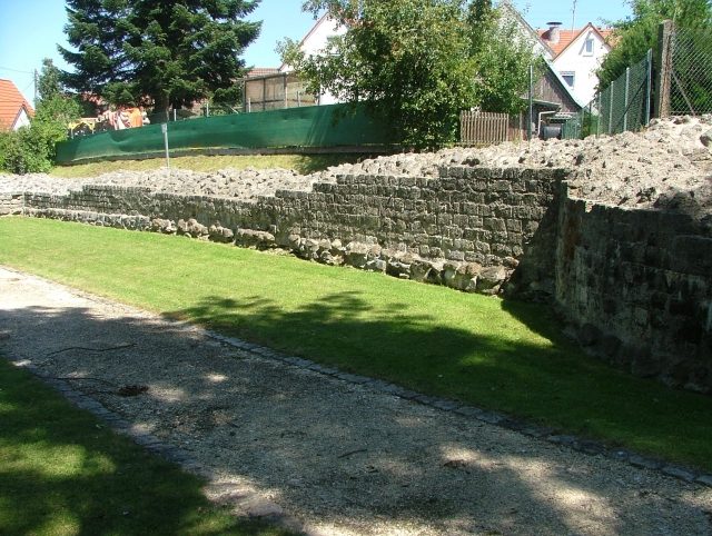
Caelius Mons (German: Himmelsberg) was a late antique cohort fort of the Danube-Iller-Rhine Limes (DIR) in the province of Raetia secunda and is part of the Kellmünz Archaeological Park in Kellmünz an der Iller in the district of Neu-Ulm. The current municipal name Kellmünz could be traced back to "Caelius Mons".
The fort was located in the present-day western village center of Kellmünz and is almost completely built over. On the southeast corner of the complex is the Roman Catholic Church of St. Martin. The location was favored by a ridge that rises 35 m above the Iller (Hilaria) valley. On its eastern side, this is more easily accessible, which necessitated special fortification of this section.
The name is handed down in the Notitia dignitatum as Caelius after Caelius, one of the seven hills of Rome. The garrison of the fort is named as cohors III Herculea Pannoniorum.
The complex belongs to the late Roman Danube-Iller-Rhine Limes, a border fortification that was built around 300 AD after the fall of the Upper Germanic-Raetian Limes along these rivers. Compared to the forts of the middle and high imperial period, smaller complexes were built that exploited strategically favorable terrain situations. Very similar complexes of the Danube-Iller-Rhine Limes existed nearby, among others in Kempten (Cambodunum) on the Burghalde, Isny (Vemania fort) and Gundremmingen (Bürgle). Most of these complexes existed until the early 5th century AD.
In the Middle Ages, the fort was gradually demolished and the material used for castle and church construction.
Research History+
Already in the middle of the 19th century, Roman wall sections were discovered in Kellmünz. Systematic excavations of large parts of the stone defensive wall took place between 1901 and 1913 by the history-enthusiastic Kellmünz merchant Roman Lindner and his three sons. The autodidacts were advised by the archaeologist Paul Reinecke (1872–1958). During these investigations, a large number of partly high-quality spolia were recovered from the late antique masonry, including architectural parts of monumental buildings and large marble statues cut to size for installation. The sale of these spolia to the Bavarian National Museum in Munich financed the elaborate excavations in the first years.
Between 1986 and 1993, the University of Munich, under the direction of archaeologist Michael Mackensen, carried out extensive excavations again. Subsequently, the Kellmünz Archaeological Park was established, where the visibly preserved fort remains are accessible to the public.
Complex+
Terrain and Extent of Construction
The excavations provided evidence of a polygonal fort that was excellently protected by the terrain. The slopes on the west and southwest sides fall steeply to the Iller. On the north side, the plateau is separated by an erosion channel from two further spur-like rock outcrops. Only on the east side was approach easy. Here was the "front" of the camp with the only larger gate; at this point, the wall was up to 3 m thick. Due to the size of the camp, the unit could have been up to 300 men strong.
Only a short time before construction began, a small settlement of half-timbered construction was erected at the site of the later fort. A building cut during Mackensen's excavations had channel heating. Two freshly minted coins, found under the screed of this house, date its origin to no earlier than 297 AD. A pointed ditch, about 4.5 meters wide, was dug around this settlement, separating the plateau to the east. The excavators suspected that these settlement structures could have belonged to a construction camp. The construction of the fort itself began in the last years of the 3rd century.
Along the east side, a pointed ditch (5–6 m wide, 2.5 m deep) and a 6 m wide flat-bottomed ditch served as obstacles to approach. The walls with an opus caementitium core largely consisted of reused spolia in the lower section. They enclosed an inner area of 0.86 ha with a length of 101.50 m and a width of 98.50 m. Approximately 14 towers were embedded in the wall, mostly semicircular, projecting at the gate, and ¾-round at the corners of the east side. A tower with a rectangular ground plan on the west side is likely to have been built due to static problems with the eroded steep slope.
Interior Construction
The focus of Mackensen's excavations was the cemetery area around St. Martin's Church. In Roman times, this area was located directly behind the gate and south of the fort's main road. This road ran straight through the main gate and thus formed the surveying axis for the other roads, which is why the interior construction should also show a fairly regular layout.
Initially, there was a 6.8 m wide and approximately 26 m long building with a latrine and screed floor, the superstructure of which was built of half-timbering. An interpretation as a barracks is plausible. Shortly after its construction at the end of the 3rd century, the wooden interior structures burned down. The excavators found a thick layer of fire in the area of the so-called "head building" of the barracks, which, based on the coins found, could be dated to the years 300/303, and which could also be proven in other parts of the fort. The cause of this fire catastrophe could not be determined. Mackensen therefore leaves it open whether carelessness, natural disaster, or an act of war is to be assumed here. However, he rejects connecting a coin hoard from 308 found outside the fort with the devastating fire. Perhaps its concealment is related to the then short-term expansion of the sphere of influence of the co-emperor Maxentius (306–312), who ruled together with Constantine the Great as part of the 2nd Tetrarchy.
During the reconstruction around 310, a 26 x 14 meter single-nave stone building was erected parallel to the east wall in place of the barracks. This monumental building, identified as an Aula, had a gabled roof and a semicircular, apsidal end. Mackensen assumed that such a large building without further adjacent rooms can only be explained by the at least temporary presence of a high civil and/or military official. This unusual finding for Raetian forts can otherwise only be found in late Roman forts of the Pannonian province of Valeria in present-day Hungary (e.g., Fort Tokod, Fort Pilismarót). However, similar apsidal buildings were only built there in the late 4th century in conjunction with a large horreum (storage building) each. Furthermore, Aulas of this type are attested in the provincial capitals and residences of the Roman Empire.
Although Mackensen had to determine during his excavations that the youngest Roman-era layers of the fort were destroyed, settlement activity can still be proven for the first decades of the 5th century based on the roller-stamped Argonne sigillata found. The archaeologist assumed that the Cohors III Herculea Pannoniorum, which was already heavily Germanized at that time, was stationed in Kellmünz at least until around 430 AD, if not until the middle of that century.
Take Mobile History with you
You are reading this text for free. Premium adds what matters on the road: descriptions read aloud, sites found through your camera, whole regions taken offline.
- Every description, including the ~17,700 Premium sites
- Audio guide: have descriptions read to you on location
- AR finder: see sites through your camera, with distance and bearing
- Unlimited saved sites
14 days free, then from €2.99 a month. Cancel anytime.
Source: Wikipedia · Licence: CC BY-SA 4.0
This description draws on the facts documented in the linked Wikipedia article; Wikipedia content is licensed under CC BY-SA 4.0. Wording and editing: Mobile History.
Location: 48.1201, 10.1268