The remains of the roman Castle can be visited
Ancient BuildingBoppard
Roman Castle Bodobrica
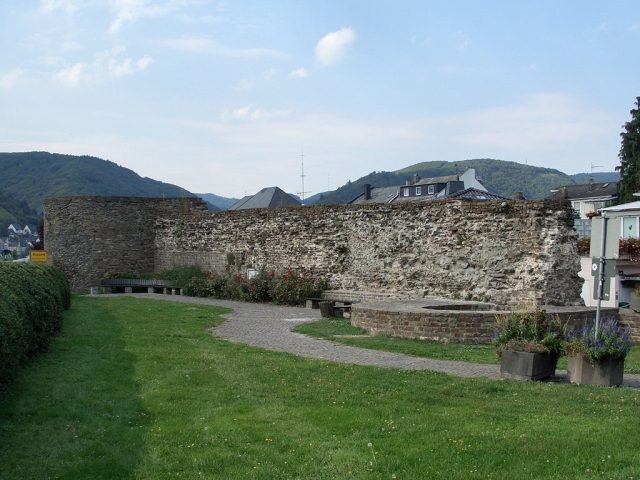
The Boppard fort (Latin: Bodobrica, also: Bodobriga, Baudobriga or Baudobrica) was a late Roman military camp on the Rhine Valley Road, whose garrison was responsible for security and surveillance tasks on the "wet" border (ripae) of the Rhine. The complex is now located in the center of Boppard, a city in the Rhein-Hunsrück-Kreis, Federal Republic of Germany. The remains of the ancient fortifications are of particular interest for scientific research due to their exceptionally good state of preservation.
Location+
Roman settlements at this conveniently located site on the Middle Rhine between the Taunus and Hunsrück have been detectable since the 1st century. Historical sources from the 2nd-3rd century, such as the Tabula Peutingeriana and the Itinerarium Provinciarum Antonini Augusti, mention the settlement as Bouobriga or Bontobrice. The name probably goes back to an earlier Celtic settlement Boudobriga. The remains of this Roman fort are located in the present-day old town center of Boppard.
Research History+
During the construction of the Boppard sewage system in 1939, several archaeological finds were uncovered and published in the Bonner Jahrbücher in 1941. Evidence of the western side of the Roman fort's fortifications at towers 2 and 3 was provided. Until then, it was assumed that this part of the fort had been destroyed by the construction of the railway line on the left bank of the Rhine. In addition, two Frankish graves with grave goods were found. An interesting individual find that came to light was a Cautes, a figure from the Mithras cult.
As part of a research program launched in 1959 to survey Roman fortifications in Middle Rhine cities, the remains of several watchtowers of the enclosure were uncovered. Based on this research program, the fort was investigated between 1959 and 1962 by the art historian Günter Stein (1924–2000). This research, carried out in conjunction with the Technical University of Berlin, was published in the Saalburg-Jahrbuch 23 in 1966 and has since served as the basis for all subsequent investigations.
The first systematic excavations were carried out between 1963 and 1966 during renovation work on St. Severus Church and construction work on the market square by the then Office for Prehistory and Early History in Koblenz. During the excavations under St. Severus Church, an early Christian baptismal font from the 5th century was found. Further excavations were carried out in 1977 in connection with road repairs on federal highway 9 at the west gate and on the southern part of the western fort wall. The course of the western section of the wall could be determined, and the presumed west gate on today's Oberstraße could also be proven.
Further extensive excavations took place between 1989 and 1995 in connection with the relocation of federal highway 9 and the planned construction of a police station. These were carried out in the area of the so-called Stierstall in the southern forefield and within the fort walls on Angerstraße. There, the fortress wall could be completely uncovered over a length of more than 55 m. Tower 8 is only preserved up to the current ground level, while tower 9 is preserved up to a height of eight meters. Due to these finds, the monument office prohibited the construction of the police station and demanded that the area be left undeveloped.
Construction History+
After the Rhine once again became the border of the Roman Empire in the 3rd century, the Bodobrica fort, measuring approximately 308 x 154 meters, was built around the middle of the 4th century AD to protect against Germanic tribes. This defensive structure was located about one kilometer southeast of the then settlement and was surrounded by an eight-meter-high wall with probably 28 towers. The fortress-like bulwark served as a military base and trading post. In contrast to other late antique forts in the Rhineland, such as those in Remagen, Andernach, Koblenz, Bingen, and Mainz, no existing buildings had to be taken into account. The Boppard fort appears to have been built as a planned construction based on geographical, military, and economic considerations.
On the field side, the defensive wall consisted of small ashlar blocks, mostly made of greywacke. Towards the town side and inside the towers, more or less roughly hewn stones were observed. Layers in the form of herringbone patterns (Opus spicatum) were built at varying heights in sections. On one of the defensive towers, whose upper finish was still preserved, the remains of two "arrow slits" could still be observed under the medieval construction. A similar finding also exists from Andernach (Antunnacum).
The fortifications of the late antique Boppard fort are among the best preserved of their kind in Germany and can be visited freely. Excavations also uncovered the remains of the thermal baths and several early Christian graves from the 7th century.
Complex+
Fort
The fort measured 308 m x 154 m. The surrounding stone wall was three meters thick, except on the Rhine front, where it was only two meters. In some places, the wall is still preserved to a height of nine meters today. On the outer wall, there were presumably a total of 28 round towers at regular intervals of approximately 27 m. There was an entrance at each of the narrow sides of the fort, without any gatehouses or towers present there. A narrow gate could be proven on the south side, and such a gate is also presumed on the north side, but it could not be proven. The Rhine Valley Road passed south of the fort, and a main road, corresponding to the current course of Oberstraße, ran through the fort.
Fort Bath
At the current location of St. Severus Church, there was a military bath, which was built together with the fort. It measured 50 m x 35 m and was built directly against the north wall. The arrangement of its rooms corresponded to the usual building scheme of Roman bath complexes. The building consisted of shaly greywacke and had reddish-brown exterior plaster. The roof was covered with red tiles and the windows were glazed.
Through an antechamber, a visitor reached changing rooms and from there to a room leaning against the fort wall with a floor area of 20 m x 9 m. This was probably used as a multi-purpose room. To the east, another room with an apse adjoined this room. This was equipped with underfloor heating and served as a warm room. The actual bath wing adjoined this room to the south. It consisted of a cold bath, a warm bath, and a sweat bath. Fresh water for the basins was supplied from the southern slopes, and wastewater was discharged into the Rhine through a lead channel. The bathing basins had a maximum water depth of 80 cm.
Coins of Emperor Constantius, minted between 341 and 346, were found under the floor of the changing room. In addition, timestamps from the 22nd Legion were found. This allows for a dating of its use until at least 352/355. After the fort was abandoned at the beginning of the 5th century, the fort bath was built over with a church, the predecessor of today's Severus Church.
Vicus
The early Roman settlement had Celtic origins. Linguistic studies and written traditions suggest that this originally Celtic village was called Bodobrica. The village was located directly on the Rhine at the edge of the Mühlbach valley. The Rhine Valley Road was connected to the Ausoniusstraße through the Mühlbach valley. The fishing and trading village flourished between the 1st and 3rd centuries. No finds from the late Roman period have been made in this area. Therefore, it can be assumed that the settlement was moved to the fort built in the middle of the 4th century. This is located approximately one kilometer east of the original settlement.
The Vicus extended over approximately 50 m and consisted of solid houses, some of which had cellars. The inhabitants were quite wealthy during the 2nd and 3rd centuries, which can be concluded from the elaborate tombs erected along the Roman long-distance road.
Troops
According to the Notitia Dignitatum, a Roman state handbook from the first half of the 5th century, milites balistrarii, a type of fortress artillery, were stationed in the fort. The fort was under the supreme command of the military leader of Germania I, the Dux Mogontiacensis.
Location of Finds
The 5th-century baptismal font found during excavations between 1963 and 1966 under St. Severus Church was left in its original location. During a renewed interior restoration of the church in 2010 and 2011, the room and access to the baptismal font were also remodeled. Since December 2011, this baptismal font can therefore be viewed during church tours.
A terracotta figure was found in one of the former houses of the Vicus. It is a depiction of the Celtic horse goddess Epona, sitting sideways in a side-saddle on a horse. The clay statue has a height of twelve centimeters. The significance of the find results from its rarity and the good preservation of the colored finish. Today, the statue is in the Landesmuseum Koblenz; a copy is also exhibited in the Museum of the City of Boppard in the Electoral Castle. In addition, an enlarged copy was placed near its find spot.
Three characteristic graves out of over 40 grave pits, found during excavations between 1989 and 1990 in today's archaeological park, have been preserved and conserved there.
Other Roman artifacts are exhibited in the city museum in the Electoral Castle in Boppard.
Post-Roman Development+
After the withdrawal of the Roman troops, the civilian population continued to inhabit the Roman fort. Around 406/407, the military bath was destroyed by fire. Around the middle of the 5th century, the predecessor of today's St. Severus Church was then built on this site.
The fort walls served as the city wall of the medieval city until the 12th century. At the latest during the construction of the present St. Severus Church, the northern wall was demolished. This had become superfluous because a wall closer to the Rhine had been built. However, it was only the Archbishop of Trier, Balduin von Luxemburg, to whom Boppard was pledged by Henry VII, who had the new residential areas in the east and west protected by a medieval city fortification in the 14th century, incorporating the Roman fort walls. Thus, only the southern fort wall remained an outer wall of the medieval city fortification.
In the 19th century, larger sections of the former fort were also destroyed. In 1969, during the new construction of the "Zum Römer" hall, an eight-meter-long and four-meter-high section of the west wall was demolished against the protests of Boppard citizens. This hall, along with other buildings, was demolished again in 2007/2008 and the wall was exposed. In the 1970s and 1980s, the Federal Republic of Germany acquired properties in Boppard to realize a partial bypass for federal highway 9. In doing so, the Federal Republic also became the owner of the southwestern corner of the Roman fort. In the early 1990s, federal highway 9 was relocated, during which, with the approval of the monument preservation authorities, parts of the acquired southwestern walls with towers 1 to 5 were demolished.
Take Mobile History with you
You are reading this text for free. Premium adds what matters on the road: descriptions read aloud, sites found through your camera, whole regions taken offline.
- Every description, including the ~17,700 Premium sites
- Audio guide: have descriptions read to you on location
- AR finder: see sites through your camera, with distance and bearing
- Unlimited saved sites
14 days free, then from €2.99 a month. Cancel anytime.
Source: Wikipedia · Licence: CC BY-SA 4.0 · Image: http://de.wikipedia.org/wiki/Kastell_Boppard#mediaviewer/Datei:R%C3%B6merkastell_Boppard.jpg
This description draws on the facts documented in the linked Wikipedia article; Wikipedia content is licensed under CC BY-SA 4.0. Wording and editing: Mobile History.
Location: 50.2310, 7.5916