The remains of the roman Castle can be visited
Ancient BuildingWeißenburg
Roman Castle Biriciana
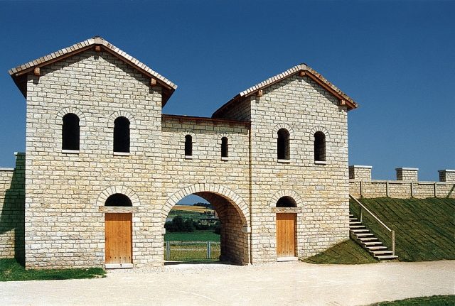
The Weißenburg fort, known in antiquity as Biriciana, is a former Roman Ala fort, built close to the Upper Germanic-Rhaetian Limes, a UNESCO World Heritage Site, and located in the urban area of Weißenburg in the district of Weißenburg-Gunzenhausen in Bavaria. Today, the fort, with its partially underground preserved structural remains, the reconstructed north gate, the large baths, and the Roman Museum with an integrated Limes information center, is one of the most important sites for Limes research in Germany.
Location+
The Weißenburg fort is located in the "Kesselfeld" area on the western edge of the city on a cleared area designated as an archaeological protection zone. The garrison was founded on a distinct rise in the ground, which slopes gently to the northwest, towards the Schwäbische Rezat. With its praetorial front and main gate, the Porta praetoria, the fortification is oriented to the southeast, while the northern, rear Porta decumana in the sloping terrain is aligned with the Rhaetian Limes, which runs about five and a half kilometers to the north. From the elevated position, the Roman garrison had a strategically advantageous panoramic view.
Research History+
The Roman name Biriciana is known from the Tabula Peutingeriana, a medieval copy of a late antique road map, but the exact localization of the site remained uncertain until the early 19th century. The historian Andreas Buchner (1776–1854) was the first in 1818, in his report "Reise auf der Teufels-Mauer" (Journey on the Devil's Wall), to advocate for Weißenburg, but he mistakenly believed that the fort was located in the Burgstall Alten Bürg, 2.5 kilometers east of Weißenburg. This assertion persisted for decades. During the reign of King Maximilian II (1848–1864), a memorial stone for the Castrum was erected on the western end of the Bürg.
In February 1868, during the construction of the railway station, the Weißenburg military diploma of June 30, 107, often cited thereafter, was found. In the vicinity of the "Kesselfeld" area, northwest of the station, only a Roman civilian settlement was initially suspected. It was the archaeology pioneer Friedrich Ohlenschlager (1840–1916) who, in 1884, based on theoretical considerations, considered this place to be the correct location of the garrison. Linguistically, the name "Kesselfeld" can be traced back to the ancient word Castellum. However, Ohlenschlager's own excavations did not yield clear results. The archaeological proof of an auxiliary fort was therefore only provided by the antiquity-enthusiastic pharmacist Wilhelm Kohl (1848–1898), who in 1890 led an excavation of the Weißenburg Antiquarian Society, founded in 1889. Until his death, Kohl continued the investigations as a section commissioner of the Imperial Limes Commission (RLK), which began its work in 1891. By 1898, all essential stone buildings of the complex were known. His successors, the Commercial Councillors Julius Tröltsch (1841–1910) and Max Raab (1860–1946), continued the actual excavations of the Imperial Limes Commission until 1913. In 1914, Raab succeeded in permanently protecting the fort area from overbuilding by spearheading the acquisition of the site by the administrative district. Subsequently, he carried out supplementary investigations in the camp area until 1917. This concluded the period of the most significant archaeological excavations at the Biriciana garrison site to date.
The most important excavation of the interwar period was a partial investigation of a smaller bathhouse west of the fort in 1926. It was located on the fort's main road there. Especially after the Second World War, there were repeated, sometimes sensational, discoveries in and around Weißenburg, in which the Bavarian State Office for Monument Preservation was usually the leading participant. The previously exposed foundations of the fort buildings themselves were backfilled in 1965 after no conservation method had proven effective. In 1976, about 1.6 kilometers from the fort, on the northeastern outskirts of Weißenburg in the "Breitung" area, a timber-and-earth camp was discovered with the help of aerial archaeology, which was excavated in three campaigns (1976, 1979, 1984/85). About 1.7 kilometers southeast of the Biriciana garrison, in the summer of 1977, the partial ground plan of another fort near Emetzheim became known, located in the "Steinmaueräcker" area. Already in March of the same year, during the construction of a settlement, the largest Rhaetian bath complex of a camp village (Vicus) to date had been discovered. Due to its importance and good state of preservation, this bath was provided with a temporary roof structure in 1983, completely restored by 1985, and ultimately secured for posterity by an elaborate protective building. An archaeological sensation was the Weißenburg treasure find, which came to light during garden work not far from the baths in the autumn of 1979. In 1986/87, subsequent excavations at the north front of the stone fort for the first time provided secure evidence for the existence of a timber-and-earth camp as a predecessor building. In 1989/90, a reconstruction of the Porta decumana was built on the original foundations, which, according to current knowledge, should probably have been one story higher. In the archaeological park, founded in 1990, which extends over the entire fort area, the contours of the defensive walls and the Principia are preserved in their course. In 2006, a magnetometry measurement was carried out on the fort area, which for the first time since the camp plan published in 1906 yielded partly new, sometimes deviating results.
The Weißenburg Roman treasure, as the most important South German find of its kind, became the centerpiece of the Weißenburg Roman Museum, a branch of the Archaeological State Collection, which was established from 1981 onwards after its acquisition by the State of Bavaria. In connection with the recognition of the Upper Germanic-Rhaetian Limes as a World Heritage Site in 2005, Weißenburg was chosen as the location for the Bavarian Limes Information Center, integrated into the Weißenburg Roman Museum, and opened in May 2006.
Construction History+
In the Domitianic period, probably around the year 90, a first timber-and-earth fort, about 2.8 hectares in size, was built at a strategically important location in the immediate vicinity of a Celtic oppidum. The garrison served to secure the territory newly conquered by Domitian north of the Danube, which had been incorporated into the province of Raetia.
Around the middle of the 2nd century, the timber-and-earth fort was replaced by a stone fort of 3.1 hectares. Probably around 253, at the latest 254, the fort and vicus were destroyed during the Alemannic invasions (Limesfall). The closing coins from a coin hoard found on the Via principalis dextra date to the years 251 and 253.
Biriciana, in its final phase of expansion, was a nearly square stone fort for an Ala, with dimensions of 170 by 174 by 179 meters. The fort wall was rounded at the corners and provided with defensive towers. The total of four gates were flanked by double towers, and between these and the corner towers, there was another, smaller tower.
The wall itself was surrounded by a double ditch; another ditch has so far only been proven on three sides of the fort. This V-shaped ditch system was only interrupted in the area of the camp gates.
The Weißenburg fort is oriented to the south with its Porta praetoria (main gate), while the smaller Porta decumana faces the Limes. Porta principalis dextra (right side gate) and Porta principalis sinistra (left side gate) correspond in size to the Porta praetoria.
The administrative and supply buildings were all constructed in stone and were located in the central part of the camp, the center of which was formed by the large Principia (headquarters building) with a flag sanctuary (Aedes) and a Basilica in front of it. Not far from it were the Horreum (granary), raised for protection against small animals, and the commander's residence (Praetorium). In the western camp area were the Fabricae (workshops) and the Valetudinarium (hospital). In contrast to these buildings, the accommodations for troops and animals consisted of half-timbered buildings. The troop barracks with the Contubernia (room communities) were located in the Retentura (rear, northern part of the camp), the stables in the Praetentura (front, southern part of the camp).
From the fort area come the remains of an armored statue, such as might once have been set up in the flag sanctuary in the Principia. These fragments date to the first half of the 3rd century AD.
Troops and Officers+
Through inscriptions, the names of both units stationed in Weißenburg as well as the names of some officers and their ranks have been preserved. A votive altar for Jupiter, walled into the Andreaskirche until 1892, names a Marcus Victorius as troop commander (Praefectus cohortis) of the Cohors IX Batavorum equitata milliaria exploratorum.
- I(ovi) o(ptimo) m(aximo) sacrum coh(ors) IX Bat(avorum) eq(uitata) (miliaria) expl(oratorum) cui praeest M(arcus) Victorius Provincia lis praef(ectus) v(otum) s(olvit) l(ibens) l(aetus) m(erito)
Translation:
Dedicated to Jupiter, the Best and Greatest. The 9th Batavian partially mounted 1000-man reconnaissance cohort, commanded by Marcus Victorius Provincialis, has fulfilled its vow willingly, joyfully, and deservedly.
The wealthy Decurio (cavalry captain) Primus Saturninus of the Ala I Hispanorum Auriana settled in Celeusum after his honorable discharge from military service in the late 2nd century AD, which, according to finds, must also have been an important place on the Limes. His 1.22 x 0.5 meter tomb inscription, which once belonged to a corresponding monument, was found in 1903 during the reconstruction of the parish church of Pförring and can now be found at the local Sebastian's Chapel:
- Prim(us) Saturninus ex dec(urione) al(ae) Auri(anae) m(issus) h(onesta) m(issione) Iul(iae) Victorinae uxo(ri) Prim(ae) Saturninae / [ ---
Translation:
Primus Saturninus, former honorably discharged cavalry captain of the Ala Auriana, to his wife Julia Victorina ...
The tombstone of an enlisted soldier, formerly also found at the Weißenburg Andreaskirche, names another Decurio named Martinus:
- D(is) M(anibus) Victor(is) cura[gentis] ex t(urma) Martini
The Optio equitum, commanding non-commissioned officer of the Ala Auriana, Flavius Raeticus, is mentioned in a dedication inscription from 153 AD. It was found in nearby Emetzheim:
- Pro salu[te An] tonini imp(eratoris) n(ostri) Mercurio sa(crum) Fl(avius) Rae ticus optio eq(uitum) al(ae) Aur(ianae) v(otum) s(olvit) l(ibens) l(aetus) m(erito) Pr[ae]sente et [Ruf]ino co(n)s(ulibus)
Translation:
For the well-being of our Emperor Antoninus. To the sacred Mercury, Flavius Raeticus, Optio equitum of the Ala Auriana, has fulfilled his vow willingly, joyfully, and deservedly. Under the consulate of Praesens and Rufinus.
The fort was probably continuously occupied by the Ala I Hispanorum Auriana (1st Spanish Cavalry Unit Auriana), with a minor interruption. The Alae (wings) were independent cavalry units consisting of 16 Turmae (sections) of about 30 to 33 riders each, with both tactical and strategic functions.
The also attested Cohors IX Batavorum equitata milliaria exploratorum could possibly be assigned to the second timber-and-earth camp located to the east in the "Breitung" area. This complex was only used during the Trajanic/Hadrianic period.
Vicus, Baths and Surroundings+
Usually, family members of soldiers, soldiers after their service, traders, craftsmen, and innkeepers settled in the civilian settlements called Vici in the immediate vicinity of Roman garrisons, and this was also the case in Weißenburg. The Vicus of Biriciana, whose exact boundaries could no longer be localized everywhere due to modern overbuilding, extended over a total area of about 30 hectares and probably reached a population of around 2500 inhabitants at its peak in the late second century.
The extensive Weißenburg Vicus included, among other things, a Mansio and three bath buildings, of which the so-called "Great Baths" are among the most remarkable buildings of their kind on German soil. A total of three construction phases could be identified for this bath complex. The first building was constructed at the same time as the fort around the year 90 and was a simple row bath, which was significantly expanded around 130 in a second construction phase. After the bath building was probably destroyed as a result of the Marcomannic Wars, a third, significantly larger and more luxurious bath complex of the ring type, with dimensions of 65 by 42.5 meters, was built around the year 180. This existed until it was severely damaged around the year 230 during the Alamannic invasions. After that, only individual remaining rooms were used for purposes other than bathing.
A Villa Rustica, located by aerial prospecting, about two and a half kilometers south of the fort, west of the road leading to Treuchtlingen, was excavated in 1985/86. It was a rather modest estate with six rooms and a walled courtyard area of 240 square meters.
Take Mobile History with you
You are reading this text for free. Premium adds what matters on the road: descriptions read aloud, sites found through your camera, whole regions taken offline.
- Every description, including the ~17,700 Premium sites
- Audio guide: have descriptions read to you on location
- AR finder: see sites through your camera, with distance and bearing
- Unlimited saved sites
14 days free, then from €2.99 a month. Cancel anytime.
Source: Wikipedia · Licence: CC BY-SA 4.0 · Image: http://de.wikipedia.org/wiki/Datei:Wei%C3%9Fenburg_Porta_decumana1.jpg
This description draws on the facts documented in the linked Wikipedia article; Wikipedia content is licensed under CC BY-SA 4.0. Wording and editing: Mobile History.
Location: 49.0309, 10.9624