The Roman Fort can be visited
Ancient BuildingKilsyth
Roman Fort Bar Hill
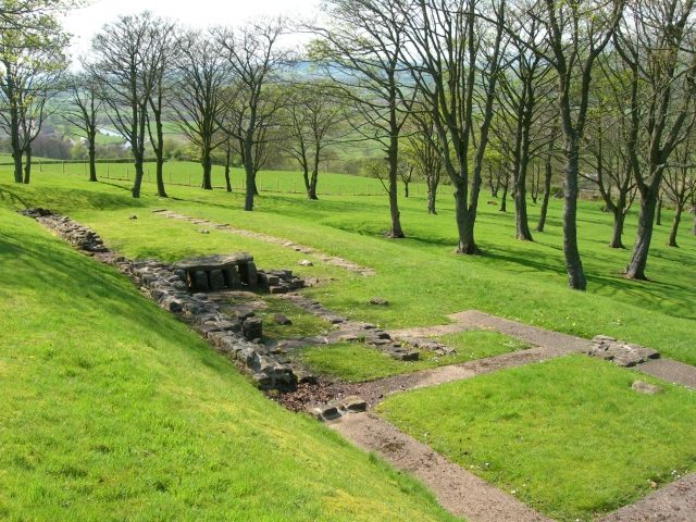
Aside from the outline of its defensive earthworks, the only visible remains here are the foundations of the principia in the fort’s interior and a linear bath-building sandwiched between the defensive ramparts and the Antonine curtain-wall, the two being detached.
The Bar Hill fort measures 375 ft. east-west by 369 ft. north-south (c.114 x 112 m) between the ramparts, giving an occupation area of almost 3¼ acres (c.1.3 ha). The fort is detached from the rampart wall itself, lying about 20 - 30 yards to the rear of it. The only other Wall fort to be built separate from the Wall was at Old Kilpatrick. A consequence of this was that the fort was defended nu a single ditch on its north side, facing the Wall, and double-ditches elsewhere. There are four gateways in the ramparts, those on the north and south placed centrally in their sides while those on the east and west are displaced slightly to the north; the gap in the ramparts to the west is not matched by a corresponding causeway across the ditches. There is a short titulum outside the ditch causeway on the south and a longer earthwork protecting the entrance gap on the east. The Military Way passed to the north, between the fort rampart and the Antonine rampart wall.
The fort was excavated in 1902-5 and 1978-82, during which a number of animal bones were uncovered, including those of Ox, Sheep, Pig, Red Deer, Boar and Fox; the latter animal very likely being hunted and killed for sport and as a means of pest control, certainly not for food. Other finds of note include a number of leather shoes, of men, women and children. Among the artifacts recovered from the interior of the fort was a wooden wheel with an iron rim, the hub of the wheel made of elm, the spokes of willow; decidedly Celtic in design. It is likely that this wheel, and fragments of another three found in rubbish pits at Newstead, were taken as booty or tribute from the lowland Caledonian tribes. Wheel ruts worn away by cart-wheels such as these were noted in one of the fort gateways during excavations.
The Roman occupation of Bar Hill was possibly first established during the campaigns of governor Gnaeus Julius Agricola sometime around AD80. A small fort of less than ½ acre was found beneath the Antonine Wall fort. It was enclosed by a defensive system consisting of a narrow rampart perhaps 10 feet in width and two (or more) ditches between 8 to 11 feet wide and around four feet deep. There was a single gateway through these defences, near which a sandal from the late-1st C. was found in the ditch infill. The occupation period of this fortlet appears to have been very short, perhaps only a single winter, abandoned when the scene of action had moved north to the Tay. Having said all this, the fortlet lying beneath the Antonine fort at Bar Hill and another at Croy Hill, are now both thought not to be Agricolan, possibly not even constructed by the Roman military, perhaps even by the native inhabitants prior to the coming of Rome.
There are two inscriptions on stone which record the presence of Roman legions in the area of the Bar Hill fort, with all three British legions being mentioned. It would appear that the Second Augusta and the Twentieth Valeria collaborated in the construction of the fort itself (RIB 2173) while the Sixth Victrix were employed building the curtain wall (RIB 2173). The Second Augusta were normally garrisoned at Caerleon in South Wales, the Sixth Victrix at York in the north of England, and the Twentieth Valeria close to the Welsh border at Chester in Cheshire.
Take Mobile History with you
You are reading this text for free. Premium adds what matters on the road: descriptions read aloud, sites found through your camera, whole regions taken offline.
- Every description, including the ~17,700 Premium sites
- Audio guide: have descriptions read to you on location
- AR finder: see sites through your camera, with distance and bearing
- Unlimited saved sites
14 days free, then from €2.99 a month. Cancel anytime.
Source: Wikipedia · Licence: CC BY-SA 4.0
This description draws on the facts documented in the linked Wikipedia article; Wikipedia content is licensed under CC BY-SA 4.0. Wording and editing: Mobile History.
Location: 55.9588, -4.0719