The Roman Castle can be visited
Ancient BuildingEining
Roman Castle Abusina
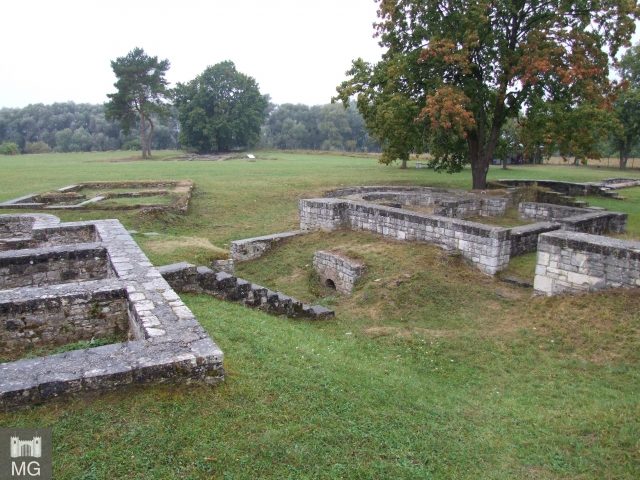
Eining Fort, called Abusina in ancient times, is a former Roman cohort fort located near the modern village of Eining, a district of Neustadt an der Donau, north of Bad Gögging. It is part of the Raetian Limes, a UNESCO World Heritage Site, and one of the few fully excavated and reconstructed defensive structures in its foundations along this section of the Limes.
Abusina Fort is located about 500 m south of the current Eining village center on the high bank of the Danube, between the road leading to Sittling and the small river Abens, which flows into the Danube just north of the fort and once gave its name to the Roman settlement.
In ancient times, it was strategically and geographically important. From this point, both ship traffic on the Danube and a road junction located here could be controlled, where a route branched off from the Roman Danube South Road in a southeastern direction, and another led west across a Danube ford. The nearest larger garrisons were the Alen Fort Pförring on the northern bank of the Danube, opposite modern Neustadt an der Donau, and the legionary camp Castra Regina, modern Regensburg. A minor disadvantage of the location, the lack of direct line of sight to Pförring Fort and to the beginning of the Limes section fortified with a wall near Hienheim, also on the northern bank of the Danube, could be compensated by an additional watchtower on the vineyard.
Research History+
The name Abusina had long been known from various ancient sources, but appeared in different spellings. The variants ABVSINA, AVSINA, ALLVSINA, AVSENA, and ARUSENA are found on the Tabula Peutingeriana, in the Itinerarium Antonini, in the Notitia dignitatum, and on inscription stones.
Thus, the early modern period already knew of the area around Eining as a former Roman site. Both Johannes Aventinus and Peter Apian, who had both secured stone monuments in Eining that have long since disappeared, mention Abusina. After that, it fell into oblivion for a few hundred years until, in the 19th century, the interest of educated bourgeois classes turned to ancient testimonies in Germany.
However, the fort was not covered by the activities of the Imperial Limes Commission (RLK), as these ended with the completion of the border section fortified with the Limes wall near Hienheim, on the other side of the Danube. The beginning of its exploration is rather due to the initiative of Eining pastor Wolfgang Schreiner, who began the first excavations in 1879, initially financing them privately. With occasional interruptions, the excavations continued until 1920, most recently under the supervision of the Bavarian State Office for Monument Protection. After that, archaeological research rested for almost half a century. Only in 1968 was scientific research resumed on the initiative of Hans Schönberger, the director of the Roman-Germanic Commission of the German Archaeological Institute.
In a competition to give the fort area a new face, a Munich design team won in 2010. It had presented plans to distribute several constructions made of oversized steel plates in the excavation area to "enliven" the archaeological site. In addition, a new entrance area, toilets, and a network of paths for visitors were planned in the now park-like landscape. Hidden wall remains are to become "sensually perceptible" with "herb planting." The tenant of Abusina, the Historia Romana association, in contrast to the public authorities, had raised concerns about the plans and would have preferred to see the necessary, considerable funds invested in the preservation of the ancient building remains.
The considerable finds from Eining are mainly distributed among the Archaeological Museum of the City of Kelheim, the City and District Museum Landshut, the Archaeological State Collection Munich, and the City Museum Abensberg. The fort area itself is today a small but attractive archaeological park.
Fort and Vicus History+
According to the foundation inscription, Abusina Fort was built around 80 AD during the reign of the Flavian emperor Titus by the Cohors IIII Gallorum ("4th Gallic Cohort") to secure the Danube line as part of the northern border of the Roman Empire. This cohort was also the first regular unit to be stationed in the new fort. In its first construction phase, the camp consisted of a timber-earth rampart and simple half-timbered buildings inside.
In the early 2nd century, probably towards the end of Emperor Trajan's reign, the Gallic cohort was replaced by a vexillatio, a detachment of about 500 to 600 men from the Cohors II Tungrorum milliaria equitata ("2nd partially mounted cohort of double strength of the Tungri"). Somewhat later, between 138 and 147, a vexillatio of a sister unit, the Cohors IIII Tungrorum milliaria equitata, probably took its place for a few years.
From 153 onwards, the Cohors III Britannorum equitata ("3rd partially mounted British cohort") with six centuries of infantry and six turmae of cavalry is attested in Eining. It remained there until the final end of Roman rule over the province of Raetia in the early 5th century. One of its first tasks was the conversion of the camp into a stone fort. This measure was related to a coordinated reinforcement of the entire regional Limes section in the Antonine period.
The necessity of the expansion measures soon became apparent. During the Marcomannic Wars under Marcus Aurelius, the province of Raetia came under severe pressure and at least partially and temporarily slipped from Roman control. During this time, the fort and vicus of Eining were also destroyed for the first time. The area between Abusina and Castra Regina could probably only be recaptured around 175 by the Legio III Italica (3rd Italic Legion) based in Regensburg. Parts of this legion were temporarily stationed in the Eining area "Unterfeld."
After the reconstruction of the fort and the camp village, a period of peace and prosperity for Abusina began, lasting until the first third of the 3rd century. The political highlight of this period was undoubtedly the visit of Emperor Caracalla to Eining in 213. Caracalla had traveled to Raetia to coordinate a preventive war against the Alamanni, who were threateningly concentrating north of the Danube. The military operations initiated then were so successful that they freed the province and thus also Abusina from the pressure of the Alamanni for another two decades.
From 233 onwards, however, the relatively stable times for the border inhabitants were a thing of the past. During a first Alamannic invasion, Abusina was destroyed again. Further waves of Alamannic raids and conquests followed until, in 260, the Roman border defense in Raetia almost completely collapsed and the province plunged into chaos. Eining was also repeatedly burned down during this Alamannic storm. Numerous hoards, including the famous "Eining Hoard," which was accidentally discovered in 1975, bear witness to this period. The 3rd British Cohort and the 3rd Italic Legion were among the few surviving military units and were the last stabilizing factors in the region.
The cohort of Abusina held its garrison until the situation in the border areas could be calmed again by the Diocletian-Constantinian army reforms at the end of the 3rd, beginning of the 4th century, and by the expansion of the Danube-Iller-Rhine Limes. The reforms created a larger mobile army stationed in the hinterland and reduced the strength of the troops directly on the border, whose barracks were converted into smaller and more strongly fortified burgi. At the same time, the Limes expansion strengthened the western flank of Raetia, which had arisen from the loss of the Agri decumates. The changes in the Roman army structure are exemplarily reflected in Eining Fort. The personnel of the British cohort was reduced, and a castle-like small fortress was built in the southwest corner of the old fort, covering - including ditches - less than a quarter of the previous area. However, the ramparts of the remaining three quarters were also maintained in the subsequent period, and the old fort area was used by both the military and the civilian population. The latter had not rebuilt the old Eining Vicus after 260 but now sought protection behind the walls of the fort.
The final demise of Abusina occurred around the middle of the 5th century, probably as a result of an advance by the Alamanni from the west. Possibly, the last Romanesque population group remaining under the protection of the fortification was among those saved by the evacuation measures of Severinus of Noricum.
The core of the Bavarian settlement of Oweninga, from which modern Eining emerged, formed about 500 m north of Abusina and only arose in the 6th or 7th century, so there is no settlement continuity here.
Fort Findings+
Due to its long existence and the repeated changes in strategic conditions, as well as multiple destructions, Abusina Fort underwent numerous reconstruction and rebuilding measures. This led to a high complexity of the building findings. The fort presented to visitors today is therefore not a snapshot of a single period, but represents a conglomerate of different construction phases. As a result, the visible structures today may initially appear somewhat confusing to the archaeological layman.
Nothing remains of the original timber-earth fort from the Flavian period. However, its ground plan was decisive for all subsequent stone forts before the beginning of late antiquity. With dimensions of 147 m long and 125 m wide, it covered an area of about 1.8 hectares, thus corresponding to the average size of a Roman cohort fort with cavalry. Initially, the fort was oriented with its Porta Praetoria (main gate) to the north; only in connection with the conversion to a stone fort in the middle of the 2nd century was the orientation changed so that the main exit gate pointed east. This change in the internal structure is largely responsible for the asymmetrical appearance seen today.
The imperial military camp of Eining was surrounded on three sides by a double pointed ditch. Each individual ditch had a width of eight and a depth of four meters. Towards the Danube, the ditch system was interrupted, probably because the steeply sloping bank and the river itself constituted a sufficient obstacle to approach. The defensive wall of the four-gated fort, rounded at its corners, had a thickness of 1.4 m and was probably five meters high. Additionally, an agger, an earth ramp, was piled up on the inside of the wall. The wall was fortified with towers at its corners, at the gates, and between corners and gates.
In the center of the fort's interior are the still visible wall lines of the Principia, the headquarters building. Here were the offices (Tabularia), the armory, and under the shrine of the standards (Aedes), the troop treasury. Slightly north of the Principia was the Praetorium, the spacious and comfortable residence of the commander. Furthermore, the camp had all the usual features for its size. However, nothing of these buildings, barracks, stables, workshops, hospital, and detention buildings is visible today. In the fort area, the remains of an armored statue were found, such as once stood for the emperor in the shrine of the standards. These fragments date to the first half of the 3rd century.
In late antiquity, the fort was significantly reduced in size. A strongly fortified, castle-like small fort was built in its southwest corner. Parts of the outer ramparts of the old camp were incorporated into the new construction, and the new fortification was separated from the remaining area by a defensive ditch. Including this ditch, the burgus covered less than a quarter of the original area of the garrison. The rest served the civilian population, greatly decimated by the wars, as a new residential area in place of the abandoned vicus. The use of Eining Fort ended in the middle of the 5th century.
Vicus Findings+
The military camp of Eining was surrounded by a fan-shaped civilian settlement, a vicus. Its main traffic axes were the Danube South Road, which had been routed in an arc around the fort, and the road branching off from this road directly in front of the Porta Praetoria to the east. The extent of the vicus itself was about 500 m in each direction from the fort gate, so that at the heyday of the camp village, it extended about one kilometer in a north-south direction and almost half a kilometer in a west-east direction.
Here, relatives of active soldiers settled, as did merchants, craftsmen, and innkeepers who met the needs of the military camp for goods and services. Later, soldiers who had completed their service joined them, as could be determined by numerous discharge certificates, so-called military diplomas, found during the excavations.
Most of the buildings in the vicus were simple half-timbered houses, but isolated stone buildings, some with underfloor heating and up to 50 m long, could also be identified using field archaeological methods and aerial archaeology.
Immediately outside the fort walls were two successive bath complexes. A first small thermal bath had been built on the steep bank of the Danube, but had to be abandoned soon due to permanent flood risk. It was replaced by a large, representative thermal bath complex equipped with all the comforts of the time, north of the fort.
Also in front of the northern front of the camp, a large, heated mansio with a small bathing section was built, a guesthouse and horse-changing station for official travelers. The Mansio of Eining was also the permanent station of the Beneficiarii, a kind of road police with customs authority, responsible for the security of the Roman long-distance road network.
The Vicus of Abusina experienced several destructions and reconstructions during its approximately 180-year history. However, after the great Alamannic storm of 260, it was abandoned. From this point on, the surviving population retreated behind the protective walls of the fort.
Watchtower on the Vineyard+
Since there was no direct line of sight from Abusina Fort to the next fort in Pförring and to the point where the fortified part of the Limes met the Danube northeast of Hienheim, a watchtower was erected on the vineyard located northeast of Eining to close this gap. This watchtower existed until the 3rd century and was probably destroyed during the Alamannic invasions. Immediately near its foundations, two other stone buildings were found, which belonged to a troop accommodation, where the crew of the watchtower was housed, and to a small temple of Mars and Victoria.
In the rubble of these structures, evidence was also found of the site's use as a Christian place of worship in post-Roman, early medieval times. Possibly, the foundations of the troop accommodation were used by the Baioarii, who settled in this area from the 6th/7th century, to erect a simple church.
Supply Camp in Unterfeld+
Only a short distance north outside the village center of Eining, under the fields of the "Unterfeld" area, lies a larger Roman military camp. With its side lengths of 328 by 320 meters, the camp covers an area of 10.6 hectares. Today, the area is cut through by the road leading from Eining to Staubing, which roughly follows the course of the former Via Principalis.
In ancient times, the camp was fortified with a turf wall and surrounded by a system of three parallel pointed ditches. With its Porta Praetoria, it was oriented towards the enemy, towards the Danube. However, the former rampart on this side is no longer present, but was probably washed away by the Danube in past centuries. The interior of the camp, apart from the Principia and the Praetorium, both built of stone, consisted exclusively of half-timbered buildings. The fort was built during the Marcomannic Wars and existed only for a short time around 175.
It is probable that the military camp in Unterfeld was a supply camp of the Legio III Italica (3rd Italic Legion) in which a part of this unit performed logistical tasks, presumably reinforced and protected by mounted auxiliary troops. However, definitive certainty about the function of the camp can only be gained through large-scale excavations.
Take Mobile History with you
You are reading this text for free. Premium adds what matters on the road: descriptions read aloud, sites found through your camera, whole regions taken offline.
- Every description, including the ~17,700 Premium sites
- Audio guide: have descriptions read to you on location
- AR finder: see sites through your camera, with distance and bearing
- Unlimited saved sites
14 days free, then from €2.99 a month. Cancel anytime.
Source: Wikipedia · Licence: CC BY-SA 4.0 · Image: Mobile Geschichte
This description draws on the facts documented in the linked Wikipedia article; Wikipedia content is licensed under CC BY-SA 4.0. Wording and editing: Mobile History.
Location: 48.8502, 11.7712