The Roman Castle can be visited
Ancient BuildingBurgsalach
Roman Castle
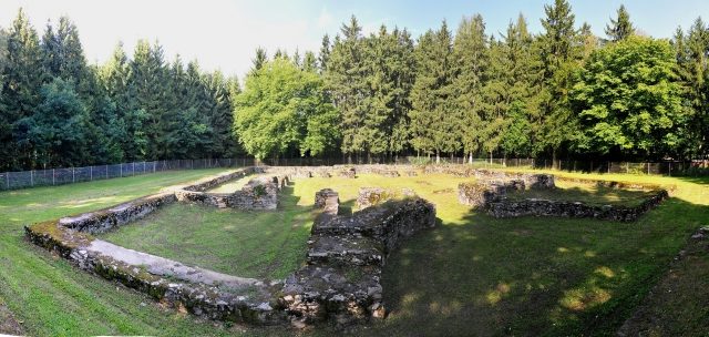
The small fort of Burgsalach is a former Roman military camp, built near the Raetian Limes, which has been designated a UNESCO World Heritage Site, and is located south of the village of Burgsalach in the district of Weißenburg-Gunzenhausen in Bavaria. The stone fortification, most likely built for a century (Centuria), is one of the youngest installations on the Upper Germanic-Raetian Limes and was founded in the 3rd century. Its architecture is unique for German forts.
The evidence of a shrine for standards (Aedes) shows that the Centuria stationed there possessed its own standard and operated as an independent tactical unit.
The small fort of Burgsalach is located on the eponymous "Harlach" field, southwest of the village of Burgsalach. It was built about 1.3 km behind the Limes directly on the then important connecting road between the forts of Weißenburg and Pfünz. This Roman road alignment is still in excellent condition in places.
Research History+
In 1790, according to a note by the Pappenheim dean and consistorial councilor Michael Redenbacher (1764–1816), the structural remains – then known as "Altes Schlösschen" (Old Little Castle) – were still "excellently preserved". Furthermore, he saw several altars dedicated to Emperor Septimius Severus (193–211). In 1800, the ecclesiastical councilor and professor of mathematics, Ignaz Pickel (1736–1818) from Eichstätt, carried out the first known excavation, which, however, yielded no significant findings "because his investigation was too superficial," as the archaeology pioneer Franz Anton Mayer (1773–1854) wrote in 1835. Nevertheless, Pickel provided a first ground plan sketch. In 1805, a follow-up excavation was carried out by Redenbacher. Many structural details found during this excavation have been preserved, which were later lost due to the increasing decay of the structure.
Mayer considered the complex to be an inn (Mansio) due to its construction method and the lack of a ditch – which Redenbacher, however, claimed to have seen in 1790. The archaeologist Andreas A. Schaflitzl agreed with this opinion in 2011, although a definitive assessment is not possible.
Persistent destruction of the area only continued after the early excavations. In particular, the rumor of a treasure buried at the "Schlösschen" encouraged looters and treasure hunters to repeatedly dig up the ruins. Apparently during a raid organized by farmers, a Roman key was unearthed in 1831, which Mayer acquired for his collection and interpreted as the key to the main gate of the inn. Due to its popularity, the Burgus became known nationwide. In 1861, King Maximilian II Joseph of Bavaria had a commemorative stele, still preserved today, erected near the ruins, which incorrectly titled the site as a Colonia.
During the war years of 1916 and 1917, in two campaigns led by Friedrich Winkelmann (1852–1934), a section commissioner of the Imperial Limes Commission (RLK), the masonry, which was still very well preserved at up to two meters high despite everything, was systematically excavated and investigated. In 1916, he uncovered the north and south fronts as well as the courtyard; in the following year, he dedicated himself to the other two wings. Winkelmann's excavations were the first and last in the 20th century. After the investigations were completed, the structural remains were backfilled to a height of one meter to preserve the partially sensitive findings.
During the first half of the 20th century, the building finally fell victim to the weather and, apparently, especially to stone robbery. The area fell out of public view and was reclaimed by nature. Only in 1962 were the trees that had grown on the site felled, and the masonry was apparently only superficially repaired. Therefore, in 1965/1966, students and teachers from the Christian-von-Bomhard-Gymnasium Uffenheim were deployed, under the guidance of the Bavarian State Office for Monument Preservation and with the support of the American military, to renovate, rebuild, and cover the remaining wall stumps with a thick layer of cement. Heavy equipment, including excavators, was also used in these works. From the rubble located in the fort area, the observation mound now in front of the main gate was erected. The gymnasium subsequently took over the sponsorship for the ongoing maintenance of the structure. The Burgus remained in this state until 2008. At that time, scientific investigations took place for the first time since 1917 with the creation of three small trial trenches. In addition, the multi-year new conservation began.
The term "Burgus," formerly most commonly chosen for this complex, actually refers to smaller late antique fort sites in the border region. The word, borrowed by the Romans from Germanic, is only attested since the end of the 4th century by Flavius Vegetius Renatus.
Construction History+
In its architectural design, no comparable fortifications have been observed on the entire Upper Germanic-Raetian Limes to date. As the archaeologist Wilhelm Schleiermacher (1904–1977) noted in 1962, the square ground plan of the Burgsalach complex had "always" been compared with late Roman fortifications in Asia Minor or North Africa, with the North African parallels always being particularly emphasized. There, Roman military camps of comparable construction dating from the late 3rd century were discovered. Furthermore, the Latin name of this type of defensive structure is also epigraphically attested from there: it is called Centenarium.
It is now assumed that the small fort, due to its architectural peculiarities, belongs to the last phase of securing and expanding the Limes, which falls within the reign of Emperor Caracalla (211–217 AD), who personally inspected the Limes and its forts in many places in 213.
Enclosure and Gate
According to Redenbacher, the building was surrounded by a ditch, still visible at the time, as an obstacle to approach. The side lengths of the slightly irregular, almost square ground plan of 32.60 (SW) × 32.40 (NW) × 31.90 (NE) × 32.60 (SE) meters correspond to 100 Roman feet. Recent research mostly assumes a fully developed second story, which could be supported by the strong walls and foundations. The garrison is said to have corresponded to a Centuria with a commanding Centurion. The interior layout of the quadrangle anticipates the design of late antique fortifications. Living and administrative rooms are arranged around a square inner courtyard and are built directly against the enclosing wall. This has a singular, 3.5-meter-wide single-gate entrance on its southwest side, which arches semicircularly inwards. Winkelmann was still able to identify the thresholds and stops of two gate leaves. Such a funnel-shaped entrance narrowing towards the gate closure was also discovered at the south gate, the Porta decumana of the Bavarian fort of Theilenhofen, at the Porta decumana of the fort of Faimingen, and at the west gate of the legionary camp of Vindonissa.
Above all, however, it could be proven at North African military sites such as the Algerian legionary camp of Lambaesis and the fort of Bu Njem (222 AD) on what is now Libyan soil. The architectural-historical classification of this gate type falls into the late 2nd century. A tower is often assumed above the archway in the small fort "In der Harlach". To the right of the passage, researchers suspect an officer's quarters or a magazine, to the left a staircase. The temporal architectural-historical classification and interpretation of the semicircular inwardly receding masonry found under the rooms to the left and right of the gate, which appears like a much wider execution of the currently visible semicircular gate closure, poses problems for science. Possibly, this older construction was already considered too large during its construction and abandoned.
Interior Construction
Opposite the gate, on the other side of the building, was a semicircular apse adjoining the northern enclosing wall, which was interpreted as a shrine for standards. Its floor was about 25 centimeters higher than the surrounding walking level. The design of shrines with apses had become common in Roman forts, especially in the Germanic region, since the mid-2nd century. In 1805, three stones of poor sandstone were still found here, whose inscriptions were partly illegible. To the left and right of the shrine for standards, the Centurion's quarters are assumed. In total, ten rooms, each with a floor area of 20 square meters, were identified on the ground floor, mostly separated by timber framing. Horizontal trenches and impressions in the mortar of the outer walls were found in the floor from these partition walls. In several of these rooms, a brick hearth was also found, which had always been installed later, as evidenced by the preserved wall plaster behind it. According to their size, these rooms could accommodate eight to ten people.
During the re-examination of Winkelmann's old excavation findings by archaeologist Renate Schiwall, completed in 2008, it turned out that there may have been a reconstruction or a change in the planning of the internal structures during construction, which could also have included the already described change to the southern outer facade. Thus, the walls enclosing the inner courtyard had been executed twice as thick as originally intended. Ultimately, this double wall, with a thickness of 1.20 meters, corresponded to that of the outer wall. Only in the area of the rear apse did the courtyard-side wall consist of a single cast. This problem had already been noticed by Winkelmann, but he had later corrected his first report and only written about one wall. There have also been subsequent changes to the enclosing wall of the complex. The inner side – with the exception of the southwest side – was structured at regular intervals by rectangular wall projections, which had a step at a height of about one meter and then continued upwards at only half the width. As the findings showed, some of these projections, which incidentally had no relation to the executed interior construction, had already been knocked off in Roman times.
In the uncovered corners of the inner courtyard, two diagonally opposite rectangular cisterns (Cisternae) were found, which made the inhabitants of the Burgus at least temporarily independent of an external water supply. The southeastern of these basins was about 1.55 meters deep during Winkelmann's excavations; the northwestern one had already been destroyed by Redenbacher, who suspected a staircase here. With the help of the follow-up excavations in 2008, some of Winkelmann's observations regarding the courtyard could be critically reviewed. It became clear that the inner courtyard was surrounded by load-bearing wooden pillars, set about 25 centimeters deep, which probably structured it in a peristyle-like manner. Thus, they probably supported a lean-to or shed roof, demonstrably covered with tiles, sloping into the courtyard, which allowed for a weather-protected walkway. Almost all the rooms on the ground floor were accessible from this walkway. However, the small walls between the wooden pillars mentioned by Winkelmann apparently did not exist and are now interpreted as a misinterpretation.
A cellar, which disturbed the structures of the older, wider archway on the southwest front, was found in the room immediately to the right of the gate entrance. How the second floor of the building was designed is unclear. However, found cornice parts indicate an external structural articulation.
Furnishings
Redenbacher reported about his excavation in 1805 that he had found the walls inside the building plastered and "marble-like covered with colorful, but mostly with red and dazzling white colors." The floors consisted of plaster and were also colored. The excavator noted in the area of the apse that the high-quality plaster floor there was white and mirror-smooth. Its surface still had a dull marble sheen. The walls of the shrine were similarly equipped. Nothing of these findings remains today. However, Winkelmann was still able to find plaster remnants during his follow-up excavations over 100 years later.
Troop+
The somewhat remote location of the Centenarium from the Limes and its clear orientation towards the Roman road explain its possible function for road surveillance. The fort garrison could therefore have belonged to the road police (Beneficiarii). Thomas Fischer suggested that the garrison was part of the subdivision of Legio III Augusta, located in Lambaesis, which was split up after 238 and, among other places, transferred to Raetia as a punishment. This could also explain the architectural proximity of the small fort to the North African camps.
Finds+
In addition to the now lost inscribed stones mentioned in 1790 and 1805, Redenbacher mentions a statuette of Priapus. Of the very sparse finds, two Terra Sigillata shards and the fragment of a Raetian bowl, manufactured in the 2nd century AD, have been preserved.
Another Fort in the Vicinity+
In 1978, aerial archaeology discovered another one-hectare camp with rounded corners 500 meters south of the Centenarium, which apparently takes into account the Roman road running there, which could allow for a closer temporal classification. Excavations have not yet taken place. According to its size, it is provisionally interpreted as a Numerus fort, although it remains open whether it is a marching camp or a longer-term occupied complex, as it has not yet been further researched. However, the complex appears to be older than the Centenarium.
Take Mobile History with you
You are reading this text for free. Premium adds what matters on the road: descriptions read aloud, sites found through your camera, whole regions taken offline.
- Every description, including the ~17,700 Premium sites
- Audio guide: have descriptions read to you on location
- AR finder: see sites through your camera, with distance and bearing
- Unlimited saved sites
14 days free, then from €2.99 a month. Cancel anytime.
Source: Wikipedia · Licence: CC BY-SA 4.0
This description draws on the facts documented in the linked Wikipedia article; Wikipedia content is licensed under CC BY-SA 4.0. Wording and editing: Mobile History.
Location: 49.0193, 11.0765