The roman Temple can be visited
Ancient BuildingNettersheim-Pesch
Roman Temple Pesch
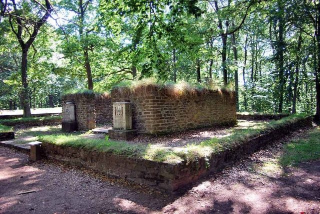
The Pesch temple district, popularly known as the Heathen Temple, is a Gallo-Roman temple complex consisting of several buildings, which existed on the "Addig" hill between the towns of Bad Münstereifel-Nöthen and Nettersheim-Pesch during the 1st to 4th centuries AD. The remains of the Matron sanctuary, partially reconstructed in their foundations today, were excavated between 1913 and 1918 and yielded a multitude of dedicatory inscriptions in honor of the Matronae Vacallinehae.
The temple district was built on a hill above the confluence of the Wespelbach and Hornbach rivers. It is a Gallo-Roman temple district that was uncovered from 1913 to 1918, with a follow-up investigation taking place in 1962. It is the best-preserved Roman cult site in North Rhine-Westphalia. Important religious and socio-historical insights for the province of Germania Inferior can be gained here. The largest extent of the complex forms an east-oriented rectangle of 100 by 34 meters from the 4th century AD. The architectural beginnings can be dated to the 1st century AD, its flourishing was reached in the 4th century, and its destruction was determined for the beginning of the 5th century.
The Cult+
Presumably, the cult site was originally a tree cult location, which in its expansion phase was dedicated to the Matronae Vacallinehae or Vocallinehae. These Matrons were possibly the patron goddesses of a group or clan called Vacalli in the area. These Celtic-Germanic mother deities appear primarily in Upper Italy, Gaul, Germania, and Britannia and usually originated from tree cults. The Matron cult is particularly widespread in the Roman Rhineland. The naming usually results from place, river, or family names. The cult image of the Aufanian Matrons, erected today in front of the complex, is a cast of a dedicatory stone from the neighboring cult site in Nettersheim from the early 3rd century AD. Other cult sites of the Matronae Vacallinehae in the vicinity can be found in Iversheim, Antweiler, Lessenich, Satzvey, and Bonn-Endenich. The male counterpart to the three female Matrons is often Mercury, whose cult was often practiced by male associations, the so-called curiae, at the same location, as the findings here also suggest. Religious life and cult activity over four centuries are reflected in almost three hundred found inscription fragments. Among them were predominantly dedications and votive offerings from locals to Matrons, but also traces of more significant deities, as fragments of a Jupiter and a Cybele cult image show.
The Present Complex+
The remains preserved today date back to the last of the three construction periods. Neither the older nor the originally wooden structural components are reproduced in the reconstruction. The complex is an archaeological and monument preservation reconstruction of the cult site, intended to combine the securing of archaeological findings and the representation of the architectural situation. For this purpose, visitors see one to two-meter-high brickwork on findings of a few centimeters in height. To visualize the cult practice, various casts of dedicatory stones are placed next to the buildings.
Construction Phases+
The buildings of the 1st and 2nd periods were demolished with the 3rd period. Except for the unchanged well, nothing visibly remains of the oldest construction phases. Due to the poor state of the findings, the use of the oldest structures can only be speculated upon and inferred from remains of the last construction period.
Period I
Mid to 2nd half of the 1st century AD.
There was a central older cult site, which received a rectangular enclosure. North of this were two square temple buildings, and a storage building was located to the south. The entire district was enclosed by a fence. East of the complex, beyond a presumed square, was an external well, which possibly served as a water source and also for ritual purification.
Period II
2nd half of the 2nd century AD.
The northernmost of the two older temples was replaced by a larger temple building, and the entire complex was probably enclosed by a surrounding wall instead of the fence.
Period III
2nd quarter of the 4th century AD.
The last period is characterized by a complete rebuilding of the complex. All older buildings were demolished, and the entire cult site was leveled. However, the new building was completely oriented to the form and alignment of the old complex, but it was not only built larger but also more systematically. This is the temple complex preserved and partially conserved today, with an extent of 100 by 34 meters.
Following the previous buildings, three cult buildings with the same alignment and equal distances of about 8.80 m (= 30 Roman feet) were erected in the west of the enlarged cult district. The square area extending across the entire width was available for processions and cult festivals.
Cult Courtyard+
Instead of the original central courtyard, a new one was created, surrounded by a boundary wall that contained many fragments of dedicatory stones from the older construction phases. A wide, representative entrance was on the east side and was flanked in the corners by two small rooms, which presumably held smaller and valuable dedicatory and votive offerings, while larger ones were erected in the courtyard itself. Located laterally in the northeastern area of the courtyard was a hexagonal temple surrounded by columns with a diameter of 1.6 meters, which can be regarded as a prominent cult site within the cult courtyard and possibly housed the stone cult image of a tree as the origin of the cult site.
Temple+
North of the courtyard, a Gallo-Roman ambulatory temple was built in place of an older temple, whose cella was demonstrably painted in color. Here too, there is an eastern entrance, which was formerly flanked by half-columns. Many older dedicatory stone fragments were also found within the foundation masonry. The ambulatory, about 3 m wide, had a colonnade with a conceivable height of three meters. The cult image of the Vacallinehian Matrons was probably found here.
Basilica+
In the south of the courtyard, a square basilica was erected on the site of an old storage building, which was plastered on the outside and had painted decoration on the inside. To the west, it had an apse, which may have had a basement. The building is a three-aisled basilica with three unfluted columns each and two half-columns each at the ends of the outer walls. The column bases are connected by low walls and possibly supported barriers. The wide eastern entrance was flanked by columns inside and out. This representative building presumably represents the assembly hall of the local men's association with the cult of Mercurius.
Secular Buildings+
A building, possibly constructed using half-timbered techniques, with a wide entrance, was located south of the basilica. It is possible that provisions and equipment were stored here. The foundations were not preserved and are therefore no longer recognizable today. Another building was located in the southeastern corner of the cult complex. The remains of this presumed accommodation for the cult personnel were also not preserved. The east side of the complex is highlighted as an entrance and display side by a limiting portico 120 meters long. It was executed as a wooden construction and included the older well. It probably served as a promenade and pilgrim accommodation, as well as a marketplace for devotional objects. The hall is now traceable in the terrain by a hedge planting.
Take Mobile History with you
You are reading this text for free. Premium adds what matters on the road: descriptions read aloud, sites found through your camera, whole regions taken offline.
- Every description, including the ~17,700 Premium sites
- Audio guide: have descriptions read to you on location
- AR finder: see sites through your camera, with distance and bearing
- Unlimited saved sites
14 days free, then from €2.99 a month. Cancel anytime.
Source: Wikipedia · Licence: CC BY-SA 4.0
This description draws on the facts documented in the linked Wikipedia article; Wikipedia content is licensed under CC BY-SA 4.0. Wording and editing: Mobile History.
Location: 50.5335, 6.7030