The remains of the roman Aqueduct can be visited
Ancient BuildingUzès
Roman aqueduct of Nîmes
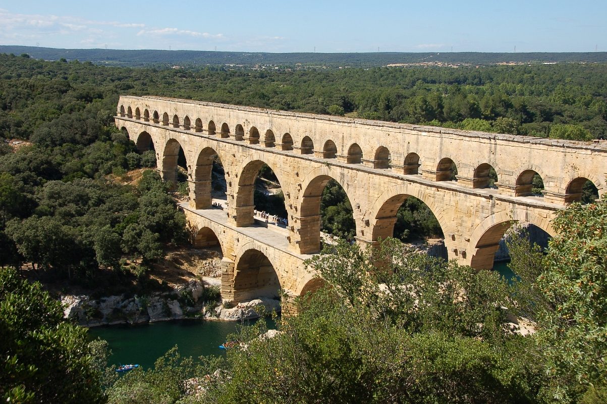
The ancient Roman Nîmes aqueduct is a 50 km-long (31 mi) structure built by the Romans to carry water from a spring at Uzès to the Roman colony of Nemausus (Nîmes). Because the terrain between the two points is hilly, the aqueduct – built mostly underground – took a long, winding route that crossed the gorge of the Gardon, requiring the construction of an aqueduct bridge. Built in the 1st century AD, the Pont du Gard is the highest of all Roman aqueduct bridges and is, with the Aqueduct of Segovia, one of the best preserved. It was added to UNESCO's list of World Heritage Sites in 1985 because of its historical importance.
After the collapse of the Roman Empire and the aqueduct's fall into disuse.
The location of Nemausus (Nîmes) was somewhat inconvenient when it came to providing a water supply. Plains lie to the city's south and east, where any sources of water would be at too low an altitude to be able to flow to the city, while the hills to the west made a water supply route too difficult from an engineering point of view. The only real alternative was to look to the north and in particular to the area around Ucetia (Uzès), where there are natural springs.
The Nîmes aqueduct was built to channel water from the springs of the Fontaine d'Eure near Uzès to the castellum divisorum (repartition basin) in Nemausus. From there, it was distributed to fountains, baths and private homes around the city. The straight-line distance between the two is only about 20 km (12 mi) but the aqueduct takes a winding route measuring around 50 km (31 mi). This was necessary to circumvent the southernmost foothills of the Massif Central, known as the Garrigues de Nîmes. They are difficult to cross, as they are covered in dense vegetation and garrigue and indented by deep valleys. It was impractical for the Romans to attempt to tunnel through the hills, as it would have required a tunnel of between 8 and 10 kilometres (5 and 6 mi), depending on the starting point. A roughly V-shaped course around the eastern end of the Garrigues de Nîmes was therefore the only practical way of transporting the water from the spring to the city.
The Fontaine d'Eure, at 76 m (249 ft) above sea level, is only 17 m (56 ft) higher than the repartition basin in Nîmes, but this provided a sufficient gradient to sustain a steady flow of water to the 50,000 inhabitants of the Roman city. The aqueduct's average gradient is only 1 in 3,000. It varies widely along its course, but is as little as 1 in 20,000 in some sections. The Pont du Gard itself descends 2.5 cm (0.98 in) in 456 m (1,496 ft), a gradient of 1 in 18,241. The average gradient between the start and end of the aqueduct is far shallower than was usual for Roman aqueducts – only about a tenth of the average gradient of some of the aqueducts in Rome.
The reason for the disparity in gradients along the aqueduct's route is that a uniform gradient would have meant that the Pont du Gard would have been infeasibly high, given the limitations of the technology of the time. By varying the gradient along the route, the aqueduct's engineers were able to lower the height of the bridge by 6 metres (20 ft) to 48.77 metres (160.0 ft) above the river – still exceptionally high by Roman standards, but within acceptable limits. This height limit governed the profile and gradients of the entire aqueduct, but it came at the price of creating a "sag" in the middle of the aqueduct. The gradient profile before the Pont du Gard is relatively steep, descending at 0.67 metres (2 ft 2 in) per kilometre, but thereafter it descends by only 6 metres (20 ft) over the remaining 25 kilometres (16 mi). In one section, the winding route between the Pont du Gard and St Bonnet required an extraordinary degree of accuracy from the Roman engineers, who had to allow for a fall of only 7 millimetres (0.28 in) per 100 metres (330 ft) of the conduit.
It is estimated that the aqueduct supplied the city with around 200,000 cubic metres (44,000,000 imp gal) of water a day that took nearly 27 hours to flow from the source to the city. The water arrived in the castellum divisorum at Nîmes – an open, shallow, circular basin 5.5 m in diameter by 1 m deep. It would have been surrounded by a balustrade within some sort of enclosure, probably under some kind of small but elaborate pavilion. When it was excavated, traces of a tiled roof, Corinthian columns and a fresco decorated with fish and dolphins were discovered in a fragmentary condition. The aqueduct water entered through an opening 1.2 metres (3 ft 11 in) wide, and ten large holes in the facing wall, each 40 centimetres (16 in) wide, directed the water into the city's main water pipes. Three large drains were also located in the floor, possibly to enable the nearby amphitheatre to be flooded rapidly to enable naumachia (mock naval battles) to be held.
The spring still exists and is now the site of a small modern pumping station. Its water is pure but high in dissolved calcium carbonate leached out of the surrounding limestone. This presented the Romans with significant problems in maintaining the aqueduct, as the carbonates precipitated out of the water during its journey through the conduit. This caused the flow of the aqueduct to become progressively reduced by deposits of calcareous sinter. Another threat was posed by vegetation penetrating the stone lid of the channel. As well as obstructing the flow of the water, dangling roots introduced algae and bacteria that decomposed in a process called biolithogenesis, producing concretions within the conduit. It required constant maintenance by circitores, workers responsible for the aqueduct's upkeep, who crawled along the conduit scrubbing the walls clean and removing any vegetation.
Much of the Nîmes aqueduct was built underground, as was typical of Roman aqueducts. It was constructed by digging a trench in which a stone channel was built and enclosed by an arched roof of stone slabs, which was then covered with earth. Some sections of the channel are tunnelled through solid rock. In all, 35 km (22 mi) of the aqueduct was constructed below the ground. The remainder had to be carried on the surface through conduits set on a wall or on arched bridges. Some substantial remains of the above-ground works can still be seen today, such as the so-called "Pont Rue" that stretches for hundreds of metres around Vers and still stands up to 7.5 m (25 ft) high. Other surviving parts include the Pont de Bornègre, three arches carrying the aqueduct 17 m (56 ft) across a stream; the Pont de Sartanette, near the Pont du Gard, which covers 32 m (105 ft) across a small valley; and three sections of aqueduct tunnel near Sernhac, measuring up to 66 m (217 ft) long. However, the Pont du Gard is by far the best preserved section of the entire aqueduct.
Take Mobile History with you
You are reading this text for free. Premium adds what matters on the road: descriptions read aloud, sites found through your camera, whole regions taken offline.
- Every description, including the ~17,700 Premium sites
- Audio guide: have descriptions read to you on location
- AR finder: see sites through your camera, with distance and bearing
- Unlimited saved sites
14 days free, then from €2.99 a month. Cancel anytime.
Source: Wikipedia · Licence: CC BY-SA 4.0 · Image: Mimova(Mimova (talk)) / Public domain via Wikimedia Commons
This description draws on the facts documented in the linked Wikipedia article; Wikipedia content is licensed under CC BY-SA 4.0. Wording and editing: Mobile History.
Location: 44.0140, 4.4260