The Villa Rustica can be visited
Ancient BuildingMesskirch
Roman Villa Rustica Messkirch
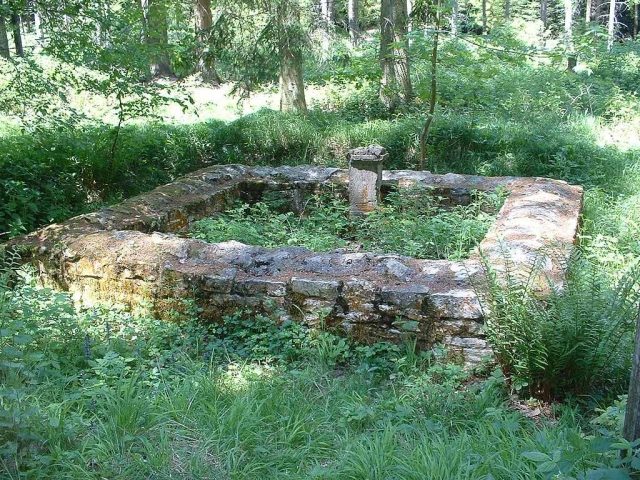
The Villa rustica is located west of Meßkirch, a small town in the Sigmaringen district in Baden-Württemberg. It is a former Roman estate. With an area of almost eight hectares, it is considered the largest known Roman country estate in Southwest Germany. Today, only rubble mounds and ramparts, as well as the reconstructed foundations of a small temple complex dedicated to the hunting goddess Diana, remain above ground.
The Roman estate is located about 4.5 km west of Meßkirch, roughly halfway between the Meßkirch district of Heudorf and the Sauldorf district of Hölzle. The archaeological site lies in the "Bändlehau" forest and extends approximately equally on both sides of Federal Highway 311, which cuts through the area. The Diana Temple is located on the northern side, slightly outside the former estate grounds.
In Roman times, the estate, due to its size, must have held a not insignificant position within the rural settlement of this region.
From 1834 to 1836, this settlement was first excavated, surveyed, and published in a small brochure by the Bietingen pastor Joseph Anton Eitenbenz. Eitenbenz at the time interpreted the findings as a Roman fortress with a praetorium, quaestorium, quarters for the cohort, a hospital, and the gates of a winter camp. Eitenbenz's discovery of the "Altstadt" (Old Town) as a Roman castrum led to the assumption that it was the Ptolemaic "Bragodurum."
In 1864, Eduard von Peucker claimed that the "Altstadt" was "Samulocenis." This meant that the fortified hill near Meßkirch was a stronghold for the defense of the entire mountainous terrain within the arc-shaped course of the Danube between Möhringen (Möhringen an der Donau) and Ennentach (Ennetach) up to the northern bank of Lake Constance.
More extensive archaeological excavations, during which the settlement could be clearly identified as a Villa rustica, were then carried out in 1882 on behalf of the Prince of Fürstenberg by J. Näher.
In 1977 and 1978, due to a realignment of Federal Highway 311, new excavations became necessary, during which, among other things, the Diana Temple, which had already been discovered during the 1882 excavations, was re-excavated, then conserved and partially reconstructed.
Estate+
The excavations uncovered a 1.2 km long enclosing wall, which encloses a trapezoidal area of almost 8 ha. The wall has side lengths of 216 m on the north side, 260 m on the south side, 354 m on the west side, and 310 m on the east side. With this enclosed area, the Villa rustica Altstadt is the largest currently known Roman estate in Southwest Germany. Within the enclosure were a total of 17 stone buildings. Slightly shifted northeast from the center, the estate was dominated by the manor house, a portico villa with corner risalits, including an inner courtyard of approximately 1600 m². Two of its rooms could be heated by a hypocaust system.
Among the other buildings, two baths, also heatable by hypocaust systems, could be identified. The supply of water to these bathhouses, as well as to the entire estate, was provided by two wells. They appear as two high rubble mounds about 100 meters south of the road.
The remaining 14 buildings were archaeologically recorded and measured, but their function has so far defied a conclusive interpretation.
The isolated estate was surrounded by an 80 cm thick wall, which, in Näher's time, was said to have had standing masonry up to 1.20 m high. Today, it can only be identified as a flat rubble rampart in the terrain. Another inner wall in the southeast of the complex probably encompassed the area of the earliest construction phase of the probably multi-phase estate.
The Villa rustica probably originated at the end of the first century AD and likely existed until the first third of the 3rd century. It probably fell victim to one of the first Alamannic incursions from 233 onwards.
Further insights into both the individual development phases and the function of the as yet unidentified buildings can only be gained through large-scale excavations.
Diana Temple+
Approximately 60 m from the northern enclosing wall () is a small temple which, according to the inscription on a votive stone found during the 1882 excavations, was dedicated to the goddess Diana. The inscription reads:
DIANA(E)
SACRVM
M(ARCVS)AVREL(IVS)
HONORATVS
PANCRATIVS
V(OTVM) S(OLVIT) L(IBENS) L(AETVS) M(ERITO)
Freely translated: "Marcus Aurelius Honoratus Pancratius has erected an altar to Diana, having gladly and freely fulfilled his vow as due."
Pancratius was probably the owner of the estate at an unknown time, likely in the 2nd or early 3rd century. The original votive stone to the goddess Diana is located in the Princely Fürstenberg Collections in Donaueschingen; a copy is on display at the site.
Neither the 1982 excavation nor the investigations of 1977/1978 could provide complete information about the appearance of the temple in ancient times. With side lengths of 3.9 m by 3.6 m, its base area was 14.04 m². It is certain that it was tiled and its floor was paved with brick slabs. Whether the recent, rising limestone masonry, possibly provided with intermediate tuff layers for visual articulation, reached the roof, or whether only a plinth was built and the rest of the walls consisted of half-timbering, can no longer be determined today. Nor can it be determined whether it was a freestanding building or the cella of a Gallo-Roman ambulatory temple, with the latter assumption being rather unlikely.
Take Mobile History with you
You are reading this text for free. Premium adds what matters on the road: descriptions read aloud, sites found through your camera, whole regions taken offline.
- Every description, including the ~17,700 Premium sites
- Audio guide: have descriptions read to you on location
- AR finder: see sites through your camera, with distance and bearing
- Unlimited saved sites
14 days free, then from €2.99 a month. Cancel anytime.
Source: Wikipedia · Licence: CC BY-SA 4.0
This description draws on the facts documented in the linked Wikipedia article; Wikipedia content is licensed under CC BY-SA 4.0. Wording and editing: Mobile History.
Location: 47.9845, 9.0542