The remains of the roman Villa can be visited
Ancient BuildingTengen-Büßlingen
Roman Villa Büßlingen
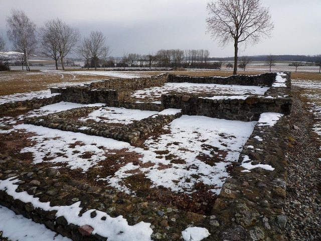
The Roman estate of Büsslingen is a restored and reconstructed villa rustica (Roman country estate) from the first century AD, which existed at least until the third century. The complex covers an area of 5.4 hectares with nine excavated buildings. It is located south-southeast of Büsslingen, a district of Tengen in the Konstanz district. After the villa rustica of Meßkirch, it is the largest known farmstead of its kind in Southern Germany and also the only one whose buildings, identified by aerial archaeology, have been completely excavated. Today it is an open-air museum.
Location and Surroundings+
Historically
The Büsslingen estate belonged to the Roman province of Germania Superior and was located between the vici of Schleitheim (Iuliomagus) in the southwest and Orsingen in the east, each 15 kilometers away. A little further to the southeast were the vici of Stein and Eschenz (Tasgetium). The distance to the Roman border forts of Hüfingen in the northwest and Tuttlingen in the southeast was approximately 24 kilometers. In the immediate vicinity of the estate, at a distance of about 1.5 kilometers, there were other Roman settlements or estates in Storzeln, Binningen, Tengen, Beuren, and Watterdingen. West of the site are the "Hochstraß" district and a road named "Hochstraße". Both could be indications of a passing Roman road, but this could not be proven.
Today
The remains, which constitute the archaeological monument, are located in the "Binningen" district of the city of Tengen in the western part of the Hegau region at an altitude of 515 m above sea level. The farm is precisely located in the "Lohgaß" district. The site is approximately one kilometer west of federal highway 314 and two kilometers east of the German-Swiss border. Closer larger towns on the German side are Hilzingen (eight kilometers) and on the Swiss side Thayngen (5.5 kilometers). The Roman road Neckar-Alb and the Heidelberg-Black Forest-Lake Constance trail pass by the area. East of the area, a small stream runs in the "Zeltengraben", to which a "channeled" inflow from the Roman farm exists to the southeast. North of the Zeltengraben lies the "Lohrenwald". The farm is situated on a gently sloping plain to the south, which connects to the deeply incised Biber valley in the west.
Excavations+
The first finds on the site of the Büsslingen estate were made around the turn of the 19th to the 20th century during drainage work. An initial publication of relief sigillata fragment finds, presumably from 1900, was made in 1913 by Otto Fritsch. Due to land consolidation activities affecting the area, excavations became necessary and began in 1976. In total, about one third of the 5.4 ha area was uncovered, and one sixth of the site was extensively investigated. The buildings were excavated in planum, with profiles rarely created. Areas between the buildings were opened with an excavator. The excavations, reconstructions, and development with paths were completed in 1982.
The client for the excavations, led by Konstanz district archaeologist Jörg Aufdermauer, was the city of Tengen, which intended to turn the area into an open-air museum. The work was supported by the State Office for Monument Preservation and the State Office for Land Consolidation Baden-Württemberg, as well as the employment office, which provided an average of twelve workers. Consequently, there was a lack of competent staff, which meant that the requirements for a modern excavation could not be met.
The excavated finds can be viewed in the Archaeological Hegau Museum in Singen. These include numerous ceramic bowls, the upper part of an amphora, fired roof tiles, and a hypocaust pillar. In addition, metal components of a bolt lock, a knife, an iron fork, scissors, a sickle fragment, a socketed scraper, a woodworking tool, three styluses, and glass shards were found. Besides a belt buckle, two bronze fibulae with enamel decorations (between 150 and 200 AD) and one without decorations were found. An Alamannic iron cross was also found on the site. A copy of the coin hoard from building 8 is on display in the museum.
History of the Estate+
Roman Management
A Terra Sigillata bowl, attributed to the late 1st century AD, serves as evidence for dating the foundation of the farm. Based on comparisons with similar finds, for example from Rottenburg (Sumelocenna) and the forts of Heilbronn-Böckingen and Bad Nauheim, a founding year between 75 and 80 is assumed. Since some of the pottery is also of Celtic origin, Romans and Celts probably lived together on the farm. In the early years, the complex was probably built in timber construction, which was then replaced by stone construction over the years, although there are no confirmed finds for this in Büsslingen. An expansion in stone construction can only be assumed from the middle of the 2nd century, at least parallels to villas in the area suggest this.
The most recent coin finds on the site were made in the wall of building 8. They had been collected and left here by a resident between 240 and 259, a total of 100 coins. The hoard represented one and a half times the monthly wage of a simple Roman soldier. One reason for leaving them in the wall could be the southern advance of the Alamanni in the years after 260 AD. The farm may have been destroyed in the process, preventing the owner from retrieving the coins in time from their hiding place. The earliest end of the estate could have been 263, as one coin, an Antoninian, from the hoard was minted no earlier than 262 or mid-263. However, the attribution of the coin to the hoard is not certain. The approximately 190 years of Roman use correspond to between six and seven generations.
After the Roman Period
What happened on the estate after the confirmed Roman settlement activity is not certain. If the Romans had left the farm, extensive household material would have remained. Furthermore, there are indications that both Alamanni and Romans used the farm in the 3rd and 4th centuries. The most important indication of use in the 4th century is a bow-brooch fibula. Other late Roman finds, while comparable, cannot be definitively assigned to a specific century. In addition, signs of a post-built structure were found in the inner courtyard of the main building, which can be attributed to the early Migration Period. None of the finds in the area prove long-term settlement activity. They only allow the assumption that the villa was either used as a Roman burial site or continued to be used by the Alamanni. They may have taken over the existing Roman agricultural infrastructure, but the residential buildings were probably not used.
Usage
The pedological assessment shows negative pseudogleying in the Tengen area. These soils are characterized by oxygen deficiency and richness in clay and nutrients. This leads to strong grass and weed growth, as stagnant water cannot drain away. In addition, the growing season is shortened on the heights of the Hegau volcanoes and the Randen. Consequently, the land around the estate was not suitable for growing crops, so the focus of use was probably on livestock farming. Bone finds on the estate prove a majority of oxen, an indication of the use of ox teams. The pig bones found show older, female animals that would have been suitable for breeding young animals. According to estimated calculations, 40 to 50 people could have lived and worked on the farm in four buildings, covering approximately 1230 square meters of usable space. The size of the cultivated area could have been up to 100 ha and could have supported approximately 50-60 cattle, 100 sheep or goats, and 50 pigs. With this size, overproduction would have been expected, which is why the farm could have served as a supply operation for the cities of Tasgetium or Iuliomagus.
Construction Technology+
Masonry
The same masonry technique using glacial rubble was used for all excavated buildings. After surveying a rectangular floor plan, workers dug foundation trenches that followed the natural slope of the terrain. These were between 40 and 120 centimeters deep and between 60 and 120 centimeters wide, depending on the function of the building. They were then filled with Hegau basalts and phonolites, creating the so-called "seepage fill". This ensured the infiltration of rainwater. On top of this, the foundation walls were laid, corresponding to the width of the trench. The two-row and two-layer walls consisted of limestone and occasionally shell limestone fragments and conglomerate blocks. The connection between the largely unworked stones was probably made with lime mortar. Only the corner stones were sometimes hewn.
The walls, which were about 10 cm narrower, were placed on top of the foundation walls. These were again two-row and consisted of unhewn stones. In some places, up to five layers were preserved. The interior was filled with stones and lime mortar. The difference was usually visible in the interior or concealed on the outside with slanted stones.
Walls
No plastering could be proven for the exterior walls; the joint line is missing on the rising masonry. The interior walls of the main building and the temple were, according to indications, plastered with white lime mortar. In a few places, remnants of geometric paintings with red and yellow stripes were present.
Doors and Windows
Only in building 4 were door sills of a 90 cm wide wooden door found. In the temple, there were indications of an entrance paved with limestone slabs. In the other buildings, there are no indications of entrances. The finds related to windows allow only a few conclusions about the type of windows. Only remnants of window panes and a window grille were preserved.
Roofs
In total, only a few roof tile fragments, 143 in number, could be secured during the excavation. Tegulae came in two different sizes, with the larger version measuring 35 by 32 centimeters. The smaller version was significantly narrower at the same length: between 15 and 19 cm. With a thickness of 2 cm, the found imbrices had a width of 16 cm and a height of 6.5 cm. For buildings 1-4 and 7, the roof tile fragments could be clearly identified. For the remaining buildings, only tile fragments were found.
Floors
In some buildings, remnants of screed floors could be detected. The screed consisted of a mixture of sand and limestone interspersed with brick chippings. It was ten centimeters thick and applied on an equally thick layer of rubble. The subfloors of the underfloor heating and the swimming pool were constructed in the same way. In one building, a secondarily burned rammed earth floor was found.
Four rooms were equipped with underfloor heating (hypocaustum), typical for that time. A hollow space was left under the actual floor, which was built with stone pillars (hypocaust pillars) supporting the floor at regular intervals. In Büsslingen, two complete pillars with a length of 38 and 60 cm were recovered. On these, approximately square brick slabs (suspensurae) were laid, which formed the base for the floor layer of lime mortar. A heating channel, which directed air into the hollow space, provided heating for the floor through firing. With continuous operation, floor temperatures of up to 30 °C could be reached. Through angular clay pipes (tubuli), smoke and heat were directed into the stone core of the walls, which simultaneously led to an additional, slight heating of the house wall. Tubuli with a hollow space of eight by eight centimeters could be secured. The oven used for heating was clad with sandstone slabs, as was the heating channel.
The Complex+
The excavated area has an approximately trapezoidal layout, typical for a scattered farmstead, and comprises nine proven buildings. The stable and the slaughterhouse were covered again after the excavation work, but a reconstruction is planned. A stone wall with approximate dimensions of 190 x 250 meters surrounded the site. A three-meter-wide farm track paved with stone slabs, leading from the east to the main building, was excavated but not reconstructed. Overall, the basic features of the buildings have been recreated using modern methods, and the originally preserved parts have been completed.
Residential and Bathhouse
The residential building is located in the central part of the site and has base dimensions of 35 x 40 meters. During the excavations, the seepage fill, parts of the foundation wall, and in the northern section up to two layers of the rising masonry were found. The single-story house was divided into ten rooms. To the left and right of the entrance hall were two, probably single-story, corner towers. These were adjoined by two rooms, each heatable by hypocaust, which in turn were followed by the sleeping and dining rooms. The house also had a storage room. The largest part of the residential building was occupied by the uncovered 600 square meter inner courtyard. During the excavations, the house entrances could not be reconstructed.
Unlike other, more luxurious villae rusticae, the Büsslingen residential building did not have a column-supported entrance hall in front of the house, but an entrance hall fully integrated into the residential building. The corner towers, now only preserved in their square outlines, were probably not recognizable as such from the outside. The reason for the absence of the usual cellar in the manor house could be the waterlogging horizon, which sometimes reached close to the earth's surface. This would probably have caused too much water to penetrate the cellar, at least periodically. The cellar was replaced by a room with a mortar floor in the western corner of the house. Architectural peculiarities include a beveled uppermost stone layer of the foundation wall and a seepage ditch on the southwest side of the house. The former was done for aesthetic reasons, the latter was due to the prevailing westerly weather conditions in this region. From this, a lean-to roof sloping outwards was concluded.
The bathhouse is located on the south side of the site and covers 200 square meters. Of the building, the seepage fill, foundation wall, and the lowest layer of the rising masonry were preserved, as well as fragmentary parts of the colored interior wall plaster and the tile covering of the cold water basin. In total, the house was divided into six rooms, all of which had a 10 cm thick mortar floor underlaid with rolled stones. On the east side was the heating room, which provided both hot water and heat for the underfloor heating. This could also be the reason for the sparsely heated main house: the residents probably spent more of their free time in the presumably continuously heated bathhouse during the cooler seasons.
A basic scheme for the process in a Roman bath had developed during the first century. After changing in the palaestra, the bather went into the cold water room, which consisted half of the cold water basin (piscina). Then he moved into the sweating bath (sudatorium) and from there either into the hot bath (caldarium) or the lukewarm bath (tepidarium). The rooms for lukewarm and hot baths were heated with the hypocaustum. The water was heated in a metal boiler and supplied to the basin through a lead pipe. The boiler was located directly on the heating pipe of the hot bath. How the water reached the bathhouse could not yet be clarified, but the drainage could. Under the basins was a seepage pit, from which a drain led outside.
Temple
The temple is located 25 meters southeast of the residential building and faces its entrance hall. With a width of nine meters and a length of 16 meters, the temple is larger than most Roman temples of this type in Baden-Württemberg. The building, of the prostylos type, was divided into two rooms, the sanctuary (cella, approx. 96 m²) and an entrance hall (approx. 54 m²). During the excavations, the seepage fill and the foundation walls were encountered. Parts of the mortar floor of the innermost sanctuary and the entrance area were also found. The roof over the open entrance hall was presumably supported by four columns, which, however, were not preserved. A striking feature of the building was the better construction quality compared to the other buildings. No indications of the deity worshipped here could be found.
Farm Buildings
In total, the estate had six farm buildings. These included a smithy, a slaughterhouse, a stable, and three other buildings presumably used as barns.
The smithy is located a short distance west of the main house. Of it, the seepage fill and large parts of the foundation walls as well as the beginning of the rising masonry were preserved. Traces of fire and ash finds in the two central rooms indicate the use of the building as a smithy. Remnants of firing systems were also found. Reddish fire traces of heat were found on the walls and corners of the rooms, suggesting multiple fireplaces. A semicircular fire trace in the clay floor of the eastern room, reaching 8 centimeters into the ground, indicates a larger oven, such as an iron smelter. In the southern room, there is only a larger fireplace, which could have belonged to a hearth, and remnants of a mortar floor. Parts of its substructure and stone slab supports, which are also glowing, are preserved. In addition, a former millstone was found, which may have served as a holder for a swivel arm. It could also be possible that the building was used as a dwelling for the employees of the farm. Under the farm smithy, the seepage fill of an older house, presumably used as a stable, was found.
The slaughterhouse is located at the easternmost point of the area. It has not yet been reconstructed, but animal bone finds in its vicinity suggest its function as a slaughterhouse. In addition, use as a gatehouse also seems possible.
At the other end of the site, in the northwest, was the farm's stable. However, only the seepage fill was preserved, so the actual function can only be surmised. The building is quite narrow and rather elongated (in contrast to the more spacious barns). Two rows of cattle stalls would have found space here.
South of the temple were two barns, and another one northwest of the main house. Of the former, only the seepage fill was preserved, but the larger floor plan indicates use as a storage building. Of the third barn, parts of the foundation walls and the rising masonry were also found. The gold coins were found in a collapsed wall of a presumed annex.
Take Mobile History with you
You are reading this text for free. Premium adds what matters on the road: descriptions read aloud, sites found through your camera, whole regions taken offline.
- Every description, including the ~17,700 Premium sites
- Audio guide: have descriptions read to you on location
- AR finder: see sites through your camera, with distance and bearing
- Unlimited saved sites
14 days free, then from €2.99 a month. Cancel anytime.
Source: Wikipedia · Licence: CC BY-SA 4.0 · Image: http://commons.wikimedia.org/wiki/File:Gutshof_Buesslingen_Gebaeude02.JPG?uselang=de
This description draws on the facts documented in the linked Wikipedia article; Wikipedia content is licensed under CC BY-SA 4.0. Wording and editing: Mobile History.
Location: 47.7863, 8.7041