The roman Bath can be visited
Ancient BuildingHüfingen
Roman Bath Hüfingen
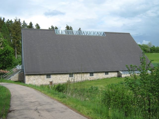
The thermal bath belonged to the fort of Hüfingen (Brigobannis). The fort is a former Roman border fort on the older Danube line of the Raetian Limes. It lies with its associated Vicus as an archaeological monument in the area of modern-day Hüfingen, a town in the Schwarzwald-Baar district in Baden-Württemberg.
The fort area of Hüfingen is located as an archaeologically invisible monument southwest of the present-day town, between the edge of the village and federal highway 31.
The Hüfingen area was already settled in pre-Roman times. For example, a La Tène period settlement existed at the later fort site on the "Galgenberg" at the so-called "Höhlenstein" until the middle of the 1st century BC. The "Galgenberg" is a spur-like hill rising up to 20 m above the Breg, which slopes gently only from the south, but rises relatively steeply from all other directions.
In ancient times, this prominent elevation with a wide panoramic view was an ideal location for a fort. In its immediate vicinity, the Roman road coming from the legionary camp Vindonissa met the southern Danube road, which began its western course here with the older Danube line of the Raetian Limes. An older route leading here from the west through the Wagensteintal and over the "Turner" is presumed, and an extension of the route from Vindonissa further north to Arae Flaviae (Rottweil) is considered probable at least from the Flavian period, so that a not insignificant intersection of Roman roads developed at this point.
Research History+
Already at the beginning of the 16th century, probing excavations were carried out on the "Galgenberg" by the then lord of Hüfingen, the Imperial Knight Hans von Schellenberg (1551/52 to 1609), and finds were recovered. After his death, however, the site as such fell into oblivion again for more than a century and a half. It was not until 1768 that Roman relics were mentioned again in the district office records.
The exploration of Hüfingen's Roman past experienced a rapid upswing with the strengthening of the educated bourgeoisie in the 19th century and its interest in antiquity. In 1820, the site was identified as Brigobanne, recorded on the Tabula Peutingeriana. In the same year, Karl Egon II zu Fürstenberg (1796-1854), considered liberal and enlightened for his time, commissioned excavations in the area of the fort bath. After the end of the excavation work, the completely uncovered balineum was provided with one of the first museum protection buildings in Germany in 1821. The first systematic description of the Roman remains also dates from this period, specifically from 1824. The then eighteen-year-old student of the "Baden Grand Ducal Gymnasium in Freiburg", Joseph Frick (1806-1875), wrote it in Latin during the Easter holidays on behalf of his teacher Heinrich Schreiber (1791-1872).
During the following decades, smaller excavations and soundings took place repeatedly, during which, among other things, the Horreum (granary) of the fort was uncovered and, with the knowledge of the time, initially misinterpreted as a temple. Finally, in 1913, the archaeological investigations of the Reichs-Limes-Kommission began, which, with war- and post-war-related interruptions, lasted until 1932. The results of the investigations, published in 1937, form the basis of today's knowledge about Hüfingen's Roman past. With this publication, Hüfingen is also the only Roman military camp on the older Danube line of the Raetian Limes that was recorded by the commission.
Thermal Bath+
The earliest uncovered, most thoroughly researched, and finally preserved under a protective structure component of the Roman remains in Hüfingen is certainly the thermal bath, the balineum, which can be found at every Roman fort. The thermal baths were built outside the purely military fort area and were also available to the civilian population. The latter, unlike the soldiers, had to pay a small fee for the use of the baths.
The Hüfingen thermal bath is located west of the fort in a valley incision below the "Galgenberg". It is a block-type balineum, in which all rooms were grouped as compactly as possible. Without extensions, it occupies an area of around 570 m², of which almost 280 m² alone are accounted for by the generously designed Apodyterium (changing and resting room). To the south of the Apodyterium are two rows of rooms, of which the western one is equipped with a hypocaust system, with which the Caldarium and the Tepidarium were heated. In the eastern row of rooms, next to the unheated Frigidarium with its separate cold water basin, was the Praefurnium, from which the eastern part of the building was heated. A circular Sudatorium located at the northwest corner of the building was probably heated separately. Whether by its own Praefurnium, which would be supported by the find of a single tubulus (heating tile), or by a simple charcoal brazier placed in the room, could no longer be determined, as the area was already heavily damaged at the time of the excavations. The room attached to the northeast corner of the building block probably served as a lounge and workspace for the thermal bath staff.
In contrast to the fort, the balineum was probably built, according to the datable finds, only in early Vespasianic times around 70 AD. However, a predecessor building is not known. After the garrison withdrew, the bath continued to be used by the Vicus inhabitants.
Fort+
The exact dating of the Hüfingen military camp has long been discussed in provincial Roman archaeology and is still not entirely certain today. The fort probably began in early Claudian times between 41 and 45 AD. A first expansion of the camp is generally assumed in late Claudian/early Neronian times, and a final expansion in early Flavian-Vespasianic times between 70 and 75 AD. The latter must be seen in direct connection with the campaign of Gnaeus Pinarius Cornelius Clemens in the Decumate lands and his expansion of the Kinzigtal road. With the advance of the Limes to the Alb line, the military significance of the Hüfingen fort probably ended around 80/85 AD, although its existence is occasionally suspected until the earliest 2nd century.
The Hüfingen fort is a complex system of a multi-phase complex with extensions made in the manner of an outer bailey, surrounded by an equally complex ditch system with at least 18 individual ditches in three to four staggered rows. It has an irregular ground plan, which adapted to the topographical conditions of the mountain spur, and occupies an area of almost 2.5 hectares in its initial phase, and an area of 3.4 to 3.6 hectares in its last expansion phase.
Due to its size and the finds, an unnamed Ala, a cavalry unit, can be assumed as the garrison, at least for the last expansion phase.
The fort was defended by a timber-earth wall in all construction phases. The interior buildings, some of which were barracks and the Principia (headquarters), were also predominantly timber or half-timbered buildings. The only building that had stone foundations was the Horreum (storage building), which was misinterpreted as a "temple" by the first excavators.
The camp was oriented with its praetorial front to the south. Only this side was flat enough to serve as a sally port for a mounted unit.
Take Mobile History with you
You are reading this text for free. Premium adds what matters on the road: descriptions read aloud, sites found through your camera, whole regions taken offline.
- Every description, including the ~17,700 Premium sites
- Audio guide: have descriptions read to you on location
- AR finder: see sites through your camera, with distance and bearing
- Unlimited saved sites
14 days free, then from €2.99 a month. Cancel anytime.
Source: Wikipedia · Licence: CC BY-SA 4.0
This description draws on the facts documented in the linked Wikipedia article; Wikipedia content is licensed under CC BY-SA 4.0. Wording and editing: Mobile History.
Location: 47.9195, 8.4801