The roman town can be visited
Ancient BuildingCaerwent
Roman City Venta Silurum
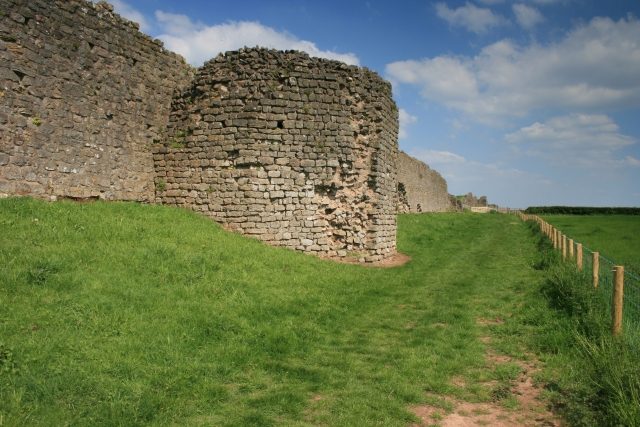
The Roman city of Venta Silurum, now better known as Caerwent, is a significant ancient site in Wales, United Kingdom. It once served as the administrative center for the Silures tribe and is notable for its exceptionally well-preserved defensive walls, offering deep insights into Roman urban planning and fortification.
History+
Venta Silurum was founded shortly after 78 AD, following the cessation of the Silures' resistance to Roman expansion. The city was laid out according to Roman standards with a rectangular street grid. Initial fortifications, consisting of earthworks and ditches, were constructed in the second half of the second century. In the fourth century, these earthworks were faced with stone. The city, which covered an area of about 18 hectares, was abandoned in the fifth century. The forum, which formed the city's center, comprised an open square surrounded by shops and a basilica to the north. Coin finds suggest that the forum was built during the time of Emperor Hadrian. East of the forum stood a Gallo-Roman temple, likely dedicated to Mars. Other structures, such as an amphitheater, circular temples, and baths, as well as richly decorated peristyle houses, characterized the cityscape.
Location+
The ancient city of Venta Silurum is located in Caerwent, in the county of Monmouthshire (Sir Fynwy) in Wales, United Kingdom, at an elevation of approximately 26 m above sea level.
On site+
The Roman city of Venta Silurum can be visited today. A large part of the area has not been built over, which allowed for extensive excavations and makes the site one of the best-researched Roman civilian settlements in Britain. Particularly impressive are the preserved city walls, which stand up to 5.2 meters high.
Nearby+
- Chepstow Castle (ruin), approx. 7.4 km away
- Piercefield House (ruin) (mansion and estate), approx. 7.8 km away
- Roman Fort Isca Silurum (ancient structures), approx. 13.1 km away
- Monmouth Castle (ruin), approx. 22.7 km away
Take Mobile History with you
You are reading this text for free. Premium adds what matters on the road: descriptions read aloud, sites found through your camera, whole regions taken offline.
- Every description, including the ~17,700 Premium sites
- Audio guide: have descriptions read to you on location
- AR finder: see sites through your camera, with distance and bearing
- Unlimited saved sites
14 days free, then from €2.99 a month. Cancel anytime.
Source: Wikipedia · Licence: CC BY-SA 4.0
This description draws on the facts documented in the linked Wikipedia article; Wikipedia content is licensed under CC BY-SA 4.0. Wording and editing: Mobile History.
Location: 51.6114, -2.7682