Roman Thermal Baths can be visited
Ancient BuildingTreves
Roman Thermal Baths Barbarathermen Augusta Treverorum (Treves)
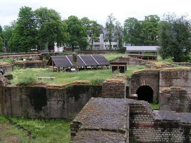
The Barbara Baths in Trier (Augusta Treverorum) are the Roman bath complex with the largest footprint built north of the Alps.
The Barbara Baths were built in the second half of the 2nd century AD. At this time, the bath complex at Viehmarkt had probably become too small for the growing city population. At the time of their construction, the baths had dimensions of 172 x 240 m (42,500 m²). They thus covered two residential blocks and a street. The water supply for the baths was provided by the Ruwer aqueduct.
The massive construction program can only be explained as a state-funded project. At the time of their creation, the Barbara Baths were the second-largest bath complex in the Roman Empire; only the Baths of Trajan in Rome were larger in area.
The bath complex apparently survived the Germanic invasions of the third century without major damage. Coin and ceramic finds attest to its use until the end of the 4th century. Operations ceased with the destruction of Trier at the beginning of the 5th century. Conversions for residential purposes are recognizable, which are interpreted as the beginning of the St. Barbara suburb.
Later Use
The size of the complex led to various uses in post-Roman times. In addition to being used as a quarry, various building installations are evident. Early Christian grave inscriptions point to a church, possibly already in Merovingian times. In the 11th century, a ministerial family became identifiable, naming themselves de Ponte after their proximity to the bridge. Various medieval fortified structures, visible as ruins on Matthäus Merian's city view and a drawing by Alexandre Wiltheim around 1620, can be attributed to them. These two drawings are the only detailed drawings of the building, and also the last: from 1611, the Barbara Baths served as a quarry for the construction of the Jesuit College, and the remaining ruins were blown up in 1675 by the French General Vignory during the conquest war of French King Louis XIV, to create a clear field around the city of Trier for tactical reasons.
The name of the baths goes back to the parish church of St. Barbara. Other church buildings may also have been located on the large bath grounds outside the medieval city wall. The location of a church St. Maria ad Pontem is largely unknown, as it was blown up by French troops in 1675. At this time, however, the reckless handling of ancient remains already had a certain tradition. Emperor Maximilian I had already ordered the still-standing parts of the baths to be shelled with cannons for testing purposes during the Trier Reichstag in 1512.
Current State
After 2000, the complex was closed to visitors for a longer period to restore the ruins. From 2009, new ways are to be found to present them to visitors. Parts of the complex are visible from the street.
Layout+
The bath building, with a size of 172 x 96 m, was planned along a N-S axis, with the bathing wings corresponding almost symmetrically on its east and west sides. The palaestra was located in front of the long entrance facade in the north, bounded by a portico.
Several niches and apses on the north side correspond to smaller cold water basins on the inside. A larger room adjoining to the south had a groin vault. This was followed by the central warm bath (tepidarium), in the case of the Barbara Baths a cruciform, hypocausted room. The hot bath (caldarium), with a size of 20 x 30 m, projected far out from the southern building front. Along the walls were niches articulated with pillars and columns, which contained rectangular basins and two boiler rooms. Two large tubs (13 x 23 m) in the form of apses also projected from the southern building front. These were accessible via promenades.
The floor plan, which featured numerous high halls and lower connecting elements between them, was designed so that all rooms received natural daylight and were easy to ventilate. The numerous apses are a very typical architectural form of the advanced second century AD. The floor plan of the Barbara Baths shows great similarity to the Hadrianic Baths of Leptis Magna.
Take Mobile History with you
You are reading this text for free. Premium adds what matters on the road: descriptions read aloud, sites found through your camera, whole regions taken offline.
- Every description, including the ~17,700 Premium sites
- Audio guide: have descriptions read to you on location
- AR finder: see sites through your camera, with distance and bearing
- Unlimited saved sites
14 days free, then from €2.99 a month. Cancel anytime.
Source: Wikipedia · Licence: CC BY-SA 4.0
This description draws on the facts documented in the linked Wikipedia article; Wikipedia content is licensed under CC BY-SA 4.0. Wording and editing: Mobile History.
Location: 49.7500, 6.6303