To be privately owned
ManorZwönitz - Niederzwönitz
Niederzwönitz Manor
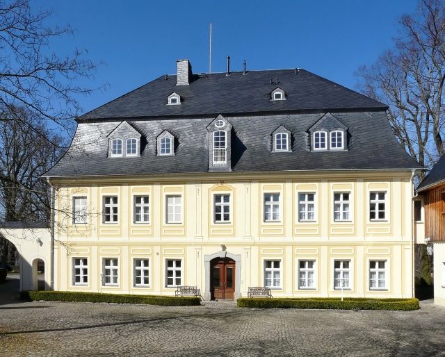
Around 1200, Niederzwönitz was founded by German settlers. Like the city of Zwönitz, Niederzwönitz also received its name from the river on which it was located. It belonged to the Stollberg dominion, with old records mentioning that the Stollberg dominion had been owned by the House of Schönberg since 1367. In the following period, the owners of the dominion changed until it was bought back by the Schönbergs in 1473.
A deed of purchase from 1552 mentions the forests belonging to the dominion (e.g., the Streitwald) and the waters between Niederzwönitz and Dorfchemnitz.
After 1564, Niederzwönitz became the seat of the dominion. The existing Vorwerk became a knight's estate, and the "Schöne Haus" (Beautiful House) was built. This stately half-timbered building can be seen in a pen drawing by Wilhelm Dillich from 1629.
In 1632, during the Thirty Years' War, "Holck's Riders" burned down the building. After the end of the war, the property was rebuilt and henceforth served as an economic estate.
On December 18, 1881, the estate burned down again, and seven of eleven buildings were consumed by the flames. Fortunately, no people were harmed, and the livestock could also be saved.
Under the direction of the estate manager and district administrator, forester Maximilian Frisch, the buildings were rebuilt in 1882. During this time, the Bergmeistergut served as a summer residence for the Schönberg family. The land complex of the knight's estate included approximately 592 hectares of agricultural land, approximately 495 hectares of forest, as well as the "Beigüter" (subsidiary estates) Bergmeistergut, Hansgünthergut, Bochmannsches Gut, and the lordly Jägerhaus with a sawmill.
Since 1929, Nikol Freiherr von Schönberg lived with his family in the Bergmeistergut. Considered a large landowner and dispossessed by the communist dictatorship after 1945, the family could only save themselves from internment by fleeing. In connection with the construction of new farmsteads after 1945, valuable buildings and facilities on the estate grounds were removed.
Take Mobile History with you
You are reading this text for free. Premium adds what matters on the road: descriptions read aloud, sites found through your camera, whole regions taken offline.
- Every description, including the ~17,700 Premium sites
- Audio guide: have descriptions read to you on location
- AR finder: see sites through your camera, with distance and bearing
- Unlimited saved sites
14 days free, then from €2.99 a month. Cancel anytime.
Source: Wikipedia · Licence: CC BY-SA 4.0 · Image: Thomas Eichler
This description draws on the facts documented in the linked Wikipedia article; Wikipedia content is licensed under CC BY-SA 4.0. Wording and editing: Mobile History.
Location: 50.6435, 12.8235