Nursing home
CastleVohburg
Vohburg Castle
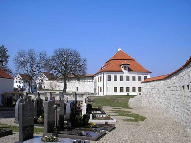
The remains of Vohburg Castle are located above the town of Vohburg in the district of Pfaffenhofen an der Ilm in Upper Bavaria. The curtain wall and the gatehouse of the high medieval castle complex have been preserved. The ruins of the hilltop castle are situated on a rock outcrop by the Danube.
The town area and the castle rock were formerly in the riverbed of the Danube and were already settled in the early Bronze Age. Traces of settlement from the La Tène and Roman periods have also been archaeologically proven on the rocky southern spur of the Franconian Jura.
By the end of the 10th century AD, a larger fortified farm was located on the castle hill. By 1040, the Counts (from 1055 Palatine Counts) of Rott-Vohburg were already residing at the fortress. Through the widow of the last Count Kuno II (son of Palatine Count Kuno I of Rott), the lordship passed after 1081 to Count Ratpoto V of Cham, who, however, succumbed to a plague in 1099.
From 1120, the lordship was in the possession of Diepold III, who belonged to the Diepoldinger family, closely related to the Rapotonen. The castle became a main stronghold of this important high noble family, whose numerous burgmannen and ministeriales appear in contemporary documents. However, after the divorce of the lord of the castle's sister from King Frederick in 1153, the family significantly lost influence. After the death of Berthold II (1204), the Dukes of Bavaria occupied the fortress and made it the center of the Vohburg district. Duke Ludwig the Kelheimer, as the brother-in-law of the childless Berthold, laid claim to the lordship, which could only be enforced by force.
In the middle of the 13th century, the Dukes developed nearby Ingolstadt into a center of power and administrative center, as the rightful lords of the castle never gave up their claims to the imperial estate of Vohburg until the death of the last Diepoldinger (1257). However, Vohburg Castle was also rebuilt, expanded, and upgraded as an administrative center. Next to and around the castle hill, the Dukes established the market town of Vohburg, from which the later city developed.
In 1246, the wedding of Conrad IV of Hohenstaufen to Elisabeth of Wittelsbach took place at Vohburg.
In 1316, the castle was destroyed by the troops of Louis the Bavarian and subsequently pledged to the Burgraves of Nuremberg. Reconstruction only began in 1414 under Duke Ernst.
It is unlikely that Duke Albrecht III secretly married the bath attendant's daughter Agnes Bernauer here in 1432.
The unfavorable location between the nearby cities of Ingolstadt and Neustadt significantly hindered Vohburg's development. The market and castle never achieved a prominent position among the ducal centers of power on the Danube. Whether the settlement was elevated to a city in the Middle Ages is disputed.
During the Thirty Years' War, the final destruction by the Swedes occurred in 1641. However, the engraving by Matthäus Merian in the "Topographia Bavariae" (1648) still shows the town and castle completely intact.
In 1721, the commissioner Johann Kastl erected the Pflegschloss (administrative castle) as an annex to the Romanesque curtain wall. In 1809, Emperor Napoleon spent a night in the Pflegschloss. In 1959, the slender "Bergfried" (keep) in the west was "reconstructed." In 1971/81, the 13th-century curtain wall was extensively renovated.
Vohburg Castle was once one of the largest and most important fortifications in Old Bavaria. However, in many modern travel guides, the castle and town are completely overlooked.
Description+
Of the high medieval castle complex of the Wittelsbachs, only the renovated curtain walls made of regular Eichstätt limestone ashlar, the impressive castle gate, and a semi-circular tower next to the gate remain today.
The irregular oval of the castle wall follows the course of the castle rock. The wall is partly preserved or reconstructed with the battlement and is accessible in some places. From here, a magnificent view opens up over the town and its districts, as well as the natural surroundings. To the north, one looks at the Jura plateau, to the west at the Irsching power plant and the Danube floodplains, to the east also at the Danube floodplains, and to the south, in the greater distance (Dürnbucher Forst), the ascent to the Tertiary hill country can be seen.
The main gate is considered one of the most important medieval gatehouses in Upper Bavaria. The plastered forepart projects rectangularly from the wall line. Next to the pointed-arch main entrance, a small pedestrian gate opens. However, the gable roof dates from the reconstruction after a fire in 1891. Inside the castle gate is the oldest preserved depiction of the Bavarian coat of arms from 1477.
The Pflegschloss from 1721 was added to the old curtain wall in the west. The pleasing, two-story mansard-roofed building later served as a hospital, nursery, and retirement home and is adorned on the east side by a baroque house figure of Maria Immaculata.
The baroque parish church of St. Petrus within the wall ring is the successor to a Romanesque basilica that already served as the main church of the Vohburg market in the High Middle Ages.
The interior of the castle has long served as a municipal cemetery and is freely accessible.
Take Mobile History with you
You are reading this text for free. Premium adds what matters on the road: descriptions read aloud, sites found through your camera, whole regions taken offline.
- Every description, including the ~17,700 Premium sites
- Audio guide: have descriptions read to you on location
- AR finder: see sites through your camera, with distance and bearing
- Unlimited saved sites
14 days free, then from €2.99 a month. Cancel anytime.
Source: Wikipedia · Licence: CC BY-SA 4.0
This description draws on the facts documented in the linked Wikipedia article; Wikipedia content is licensed under CC BY-SA 4.0. Wording and editing: Mobile History.
Location: 48.7709, 11.6172