Museum
CastleVisegrád
Royal Palace Visegrád
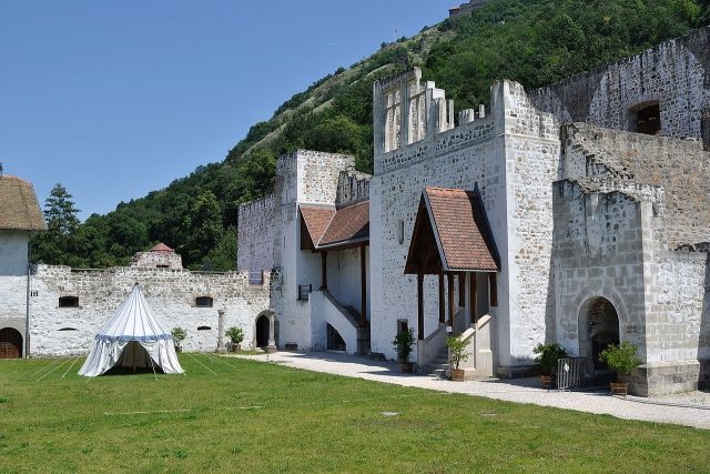
The Royal Palace of Visegrád, also known as Plintenburg, is a significant historical castle complex in Hungary. It is picturesquely located in the Közép-Magyarország region and once served as the official residence of the Hungarian kings, making it a central site in Hungarian history.
History+
The origins of the Royal Palace date back to after 1325, when King Charles I of Hungary initiated its construction. King Louis I of Hungary ordered a first expansion in the second half of the 14th century. Following extensive demolition in the late 14th century, a new, more magnificent castle complex was erected under subsequent rulers. This new complex, with a square footprint of 123 by 123 meters, served as a royal residence until the early 15th century. Between 1477 and 1484, it was rebuilt in the late Gothic style, with facades and smaller structures incorporating elements of the Italian Renaissance. The conquest by the Turks subsequently led to the complete destruction of the palace, whose ruins were covered by earth in the 18th century. Archaeological excavations began in 1934 and continue to this day.
Location+
The Royal Palace of Visegrád is located in the town of Visegrád in Pest County, in the Közép-Magyarország (Central Hungary) region, Hungary. It stands at an elevation of approximately 112 meters above sea level.
On site+
Today, the Royal Palace houses a museum. Visitors can explore already excavated and reconstructed parts of the complex, such as the former residence. The museum provides insights into the history of the castle and its elaborate reconstruction.
Nearby+
- Upper Castle Visegrád (Plintenburg) (Castle), approx. 0.5 km away
- Lower Castle Visegrád (Plintenburg) (Castle), approx. 0.6 km away
- Roman Fort Pone Navata (Ancient Buildings), approx. 0.9 km away
- Roman Burgus Verőcemaros-Dunamező (Ancient Buildings), approx. 6.5 km away
Take Mobile History with you
You are reading this text for free. Premium adds what matters on the road: descriptions read aloud, sites found through your camera, whole regions taken offline.
- Every description, including the ~17,700 Premium sites
- Audio guide: have descriptions read to you on location
- AR finder: see sites through your camera, with distance and bearing
- Unlimited saved sites
14 days free, then from €2.99 a month. Cancel anytime.
Source: Wikipedia · Licence: CC BY-SA 4.0 · Image: http://commons.wikimedia.org/wiki/File:%C3%89szakkeleti_palota.JPG?uselang=de
This description draws on the facts documented in the linked Wikipedia article; Wikipedia content is licensed under CC BY-SA 4.0. Wording and editing: Mobile History.
Location: 47.7915, 18.9742