The Abbey can be visited
MonasteryLeisnig - Klosterbuch
Buch Abbey
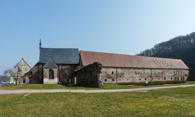
Kloster Buch, a former Cistercian monastery, is situated in Central Saxony, nestled within the river landscape of the Freiberger Mulde. The complex, which gave its name to the Klosterbuch district of the city of Leisnig, is now maintained by a support association and made accessible to visitors.
History+
The first documented mention of Kloster Buch dates back to 1192, when Emperor Henry VI guaranteed the transfer of the parish of Leisnig to the monastery. According to Cistercian tradition, the settlement was carried out by monks from Sittichenbach Abbey. The monastery, dedicated to Saints Mary, Bernard, and Aegidius, was founded on the initiative of Burgrave Henry III of Leisnig. It was generously planned, as evidenced by the preserved 70-meter-long chapter house. Over its history, the monastery acquired extensive property in 52 villages, including granges and estates in towns such as Belgern, Oschatz, and Leipzig. In 1441, the abbot of Buch received special privileges, including the right to consecrate liturgical objects and to wear the miter and episcopal ring. The dissolution of the monastery occurred between 1525 and 1526 during the Reformation, following the death of Abbot Antonius Dytz.
Location+
Kloster Buch is located in the Mittelsachsen district of Saxony, approximately 4 kilometers east of the city center of Leisnig. The complex is situated at an elevation of about 152 meters above sea level, directly at a bend in the Freiberger Mulde river, which forms a wide flood plain here.
On site+
After its dissolution, the monastic complex was converted into an agricultural enterprise. Today, a support association is dedicated to the preservation and restoration of the historic complex, which is open to visitors.
Nearby+
- Paudritzsch Manor (manor house and estate, approx. 1051 m away)
- Klosterbuch Klosterbuch train station (monastery, approx. 1328 m away)
- Klosterbuch Scheergrund hydropower plant (monastery, approx. 1620 m away)
- St. Ägidien (Altenhof) (monastery, approx. 1836 m away)
Take Mobile History with you
You are reading this text for free. Premium adds what matters on the road: descriptions read aloud, sites found through your camera, whole regions taken offline.
- Every description, including the ~17,700 Premium sites
- Audio guide: have descriptions read to you on location
- AR finder: see sites through your camera, with distance and bearing
- Unlimited saved sites
14 days free, then from €2.99 a month. Cancel anytime.
Source: Wikipedia · Licence: CC BY-SA 4.0 · Image: Thomas Eichler
This description draws on the facts documented in the linked Wikipedia article; Wikipedia content is licensed under CC BY-SA 4.0. Wording and editing: Mobile History.
Location: 51.1521, 12.9870