Municipal offices
ChurchWillanzheim
Willanzheim Church Castle
The fortified churchyard of Willanzheim encompasses the fortified areas of the churchyard around the Catholic parish church of St. Martin in the Lower Franconian village of Willanzheim. This includes parts of Hauptstraße, Marktplatz, Kirchstraße, and Pfarrgasse.
The fortified churchyard is located in the middle of the market town of Willanzheim. Situated on a gentle slope at an elevation of about 250 m above sea level, it towers over the village by up to 20 m. The horseshoe-shaped complex of the Gaden fortification today covers an area of 3893 m². From the 14th century onwards, the village was subject to changing lords, which often resulted in wars and looting. This also explains the former village fortification with a moat and hedge. The fortifications are evidenced by archaeological findings from the Bavarian State Office for Monument Preservation.
The history of the fortified churchyard is closely linked to St. Martin's Church in Willanzheim. This church was gifted to the Bishop of Würzburg in 742 and probably already had a fortified churchyard at that time. However, the oldest parts of the fortified churchyard still preserved today date back to the 14th century. At that time, the church tower was also built to gain a better overview of the surrounding areas. The fortified churchyard could be accessed through two gates, of which only the eastern one remains today. A fortification of the churchyard is explicitly mentioned for the first time in 1303.
In the 16th century, the fortification was extensively renewed. The Thirty Years' War severely devastated the church and its surrounding fortifications. Initially, the church was repaired until 1653, before attention turned to the walls and Gaden of the fortified churchyard. In the 18th century, the castle acquired the appearance that is still largely visible today. With changing political and military conditions, the fortified churchyard could no longer fulfill its purpose in the 19th century and fell into disrepair. Temporarily, the cellars of the Gaden were used as storage rooms.
The Second World War then caused further damage to the decaying Gaden fortification. On April 5, 1945, there was tank shelling and a low-level attack. Large parts of the castle were destroyed. Unlike the church, which was rebuilt in the immediate aftermath, the fortified churchyard was left untouched. It was only in the years 1998-2003 that the fortified churchyard of Willanzheim was restored, so that today the church and fortified churchyard form the actual center of the village.
Description+
The churchyard fortification runs in a horseshoe shape around the church. This shape comes about because the fortification is completely missing to the north of the church, creating a square. Gaden surround the entire, preserved churchyard, while remnants of walls are only visible in the south, west, and east.
Church
St. Martin's Church forms the center of the churchyard fortification. It is not oriented to the east; its choir, however, is oriented to the south. The show side of the church is found in the north. This is likely also a reason for the opening of the fortification on this side. Three window axes structure the building, while the sacristy adjoins the building to the west. Next to it rises an Mount of Olives group, consisting of life-sized figures.
To the east of the church, the tower adjoins the nave. It is 42 m high and thus towers over the fortified churchyard and the village. In addition to its function as a watchtower, it also had representative purposes.
Gaden
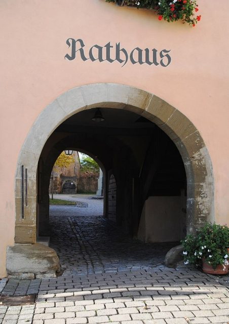
The most important Gade of the churchyard fortification is the so-called "Rathausgade" (Town Hall Gade) in the southwest of the complex. It is two-story and has a double cellar access. Dendrochronological investigations by the State Office for Monument Preservation estimate parts of the complex to date back to 1303. A double gate from 1582 leads to the actual town hall, which rises two stories towards the street. It is also part of the complex. A measuring point is located at the round-arched entrance gate. Two iron measuring tapes represent 60 cm and the common unit of the Würzburg ell (83.3 cm).
North of the town hall, inside the fortification, stands the former schoolhouse, which was subsequently built in the churchyard. It is also two-story and today houses the village's music club. Another Gade in the south of the complex was converted into the parish community center, the so-called "Martinushaus". It is single-story and was significantly altered by the renovations at the beginning of the 21st century. The former east gate originally adjoined this Gade. Today, the local Catholic library is located here.
Further Gaden rise in the south of the fortification, between the town hall and the Martinushaus. They are all single-story and mostly feature double-gated entrances and cellar entrances. Further, heavily altered Gaden buildings are located in the east of the complex.
Walls
The preserved wall remnants in the south and east of the fortified churchyard show a defensive, smooth exterior. Especially in the southern part of the fortified churchyard, the wall remnants rise with slit windows. Today, they are largely built over by the Gaden. A relief of a coat of arms is embedded in the wall in the southeast. It shows the Franconian rake, framed by two lions. Above it is the year 1619.
Take Mobile History with you
You are reading this text for free. Premium adds what matters on the road: descriptions read aloud, sites found through your camera, whole regions taken offline.
- Every description, including the ~17,700 Premium sites
- Audio guide: have descriptions read to you on location
- AR finder: see sites through your camera, with distance and bearing
- Unlimited saved sites
14 days free, then from €2.99 a month. Cancel anytime.
Source: Wikipedia · Licence: CC BY-SA 4.0 · Image: https://commons.wikimedia.org/wiki/File:Portal_au%C3%9Fen,_Willanzheim.JPG?uselang=de
This description draws on the facts documented in the linked Wikipedia article; Wikipedia content is licensed under CC BY-SA 4.0. Wording and editing: Mobile History.
Location: 49.6806, 10.2318