The church can be visited
ChurchKleinlangheim
Kleinlangheim Church Castle
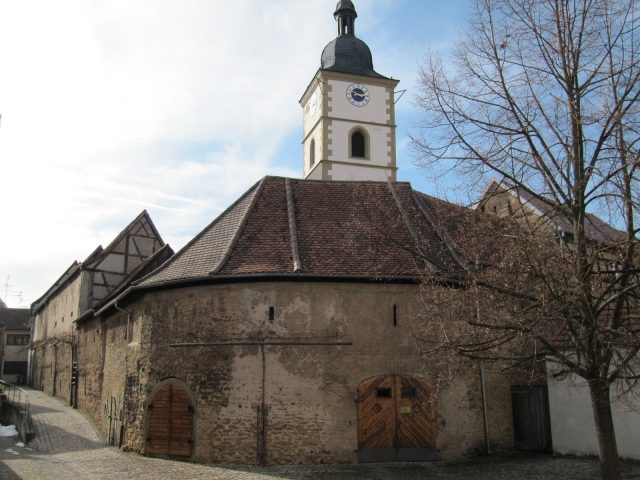
The fortified church of Kleinlangheim is a fortified church from the 12th century in the old village center of the municipality of Kleinlangheim in the Lower Franconian district of Kitzingen.
Predecessor Churches
Traces of the first churches in Kleinlangheim before the mid-7th century were found during an excavation in 1972-1973 for the installation of heating. In the nave of St. George and Mary, experts found Roman remains, an older stone base, and evidence of wooden predecessor buildings. Furthermore, parish records indicated the presence of a chapel in the tower. This was confirmed during excavation work under the floor by the discovery of an altar foundation in the middle of the rectangular apse under the tower. The vitrified sandstones and post holes told of a destructive fire that likely consumed the wooden predecessor church. Striking fragments also allowed for the reconstruction of a stepping stone made of yellowish boundary dolomite and parts of a sigma-shaped altar slab. From the discovered consecration cross, the original size of the table can be estimated at 0.78 meters in length and 0.40 meters in width. Next to the consecration cross, there was also a sealed cuboid depression. This could have contained relics. Consecrated remains from the fire-destroyed predecessor churches, built in half-timbered style, were left in the altar area of the subsequent building. Around the 10th century, the half-timbered structures of the first churches were replaced by a stone church and supplemented with a choir tower. This has been preserved to this day.
Fortification
Fortified churches have been found in Franconia since Carolingian times. They served as refuges for the protection of farmers. The rural population suffered particularly from the power struggles of the feudal lords. They were also threatened by wandering soldiers and riff-raff. The church was usually built of stone and covered with tiles. This offered protection from fire and was most suitable for defense. Furthermore, it was a sacred place that offered asylum. Even enemies respected the consecrated area of the church building and the churchyard.
The house of God was originally surrounded by the cemetery. In the 12th century, the church and cemetery were fortified with strong, high walls made of hard boundary dolomite from the surrounding area. The masonry was laid in herringbone or ear-of-corn bond ("opus spicatum").
Finally, the surrounding wall was expanded into a refuge. Battlements were built, and storage rooms (Gaden) were added inwards against the churchyard wall. These consisted of storage cellars and small houses. In them, village families could store important belongings and provisions for emergencies. Outwards, they consisted of a solid defensive wall without windows but with loopholes. The respective owners had to ensure their maintenance. Due to lack of space, the residents also built the ossuary.
As further security, palisades were erected before the excavation of the artificial moat. Its traces can be discovered in the vicinity of the town hall. The only access was protected by a drawbridge and a gatehouse. The latter was probably built in 1487 and used as the first town hall. Above the round arch is the aforementioned year. Even today, visitors can enter the churchyard through this access and appreciate the strength of the ring wall. The fortified church of Kleinlangheim was first mentioned in 1416 when it served as a base for the Burgrave of Nuremberg in the First Margrave War. Bishop Johann was able to plunder "much property, wine and grain that the farmers had fled into." Further destructions occurred in 1554 and during the Thirty Years' War. In 1648, sources describe the destructions as follows: "So the palisades in front of and around the churchyard were burned, the churchyard gates, church and church houses' doors, as well as the roofs smashed..."
Dismantling
After the Margrave Wars and the Thirty Years' War, the fortified churches lost their importance for defense in times of war. Much that was destroyed fell into disrepair. Only individual Gaden underwent numerous alterations and major demolitions for agricultural purposes by their owners. From 1700, the inhabitants of Kleinlangheim leveled the moat and created space for development or gardens.
Today, fortified churches, beyond their historical function of defensibility and protection, have symbolic character for individuals and the community. They represent a symbol for God. The gate is open towards the village as a sign that the church turns to the people. It invites to silence and strengthening or to events of the local community.
For more than 20 years, the municipality of Kleinlangheim and the Förderverein Kirchenburg Kleinlangheim e.V. have been striving to renovate and preserve the remains of the fortified church. Thus, they have a suitable setting for events.
Description+
Complex
The fortified church of Kleinlangheim consists of the church and its churchyard. This is still partly delimited outwards by a high ring wall and a gate tower, except for the north side. Within the walls, in addition to the church with its nave and tower, there are numerous Gaden with built-over cellar entrances.
Church
The freestanding church is oriented in an east-west direction and consists of the nave and the tower. It is located on the east side. The extension of the nave to the south in 1594 and again in 1685 is clearly visible.
Inside, the church received its current appearance between 1722 and 1739. On the sides where extensions took place, on the south and west sides of the nave, double-story galleries were installed.
The altar comes from Prichsenstadt. It stands in the focal point of the nave. The painting with the Easter message was created in 1849 by Friedrich Carl Hösch. In the predella below, in close proximity to the altar table, the Last Supper is depicted. Like from a grapevine, green vines lead from the base upwards along two twisted columns and frame the Resurrection.
The organ from 1669 was placed on its own gallery above the altar in 1731. Michael Voit from Schweinfurt incorporated valuable parts into the new musical instrument in 1802.
The body of the pulpit is adorned with figures of Christ as Ruler of the World and, at his side, the four Evangelists. They were financed by donations in 1725. The angel with the trumpet on the sounding board symbolizes the surrounding inscription: "Cry aloud, spare not! Lift up your voice like a trumpet, and declare to my people their transgression. Isa. 58".
On the right side, visitors will find the baptismal font. It probably dates from the 15th century, and the brass basin from 1729.
An unknown artist inserted a picture story into the cassette fields of the first gallery. It shows the most important biblical contents in a cross-section. This "poor man's bible" for people who could not read dates from around 1650.
Unfortunately, only two murals from around 1602, which were discovered during the last renovation, could be restored.
Tower
The church tower was built as a choir tower. The rectangular apse on the lowest floor was used as an altar room until the 13th century, as proven by the excavation of altar foundations. Clear Romanesque traces are also visible. A sandstone tablet testifies that it received three more floors in 1594.
Today, the tower consists of six floors with an onion dome, lantern, and weathercock. It houses the sacristy and carries the bells. The 85-centimeter-high eleven o'clock bell was cast in 1424 by "magister petrus" in Nuremberg. This was followed in 1491 by the 1.36-meter-high twelve o'clock bell. Both are richly decorated. During World War II, the small bell, added in the 16th century, was melted down. In 1958, the peal was completed again with the Eternity Bell.
Take Mobile History with you
You are reading this text for free. Premium adds what matters on the road: descriptions read aloud, sites found through your camera, whole regions taken offline.
- Every description, including the ~17,700 Premium sites
- Audio guide: have descriptions read to you on location
- AR finder: see sites through your camera, with distance and bearing
- Unlimited saved sites
14 days free, then from €2.99 a month. Cancel anytime.
Source: Wikipedia · Licence: CC BY-SA 4.0 · Image: https://commons.wikimedia.org/wiki/File:KibuKl.JPG
This description draws on the facts documented in the linked Wikipedia article; Wikipedia content is licensed under CC BY-SA 4.0. Wording and editing: Mobile History.
Location: 49.7708, 10.2858