Museum
CastleMainhardt
Mainhardt Castle
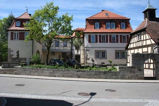
The Mainhardt Hunting Lodge (Schlössle) is a small castle complex of the Counts and later Princes of Hohenlohe from the early 17th century. The complex, referred to by locals as the Mainhardt Schlössle, is located in the center of Mainhardt in the district of Schwäbisch Hall in Baden-Württemberg.
In 1416, the village of Mainhardt came into the possession and under the rule of the noble family of Hohenlohe through purchase. At the turn of the 16th to the 17th century, the House of Hohenlohe, which had by then risen to the rank of counts, had the main building of the Schlössle with outbuildings erected in the center of Mainhardt. In 1603, this building is first mentioned in Mainhardt documents as an official residence with a horse and cattle stable. In 1644, the property is referred to as a castle in the records, and in 1652, it appears as Schlösslin in the Mainhardt files.
Furthermore, it is documented in the community records that the Hohenlohe rulers frequently organized large hunts in the game-rich forests around Mainhardt and used the official residence as a hunting lodge for this purpose.
In the years after the construction of the main building, a gatehouse and other outbuildings were erected to accommodate guests as well.
After the Reformation, the people of Mainhardt, like almost all subjects in the Hohenlohe dominion, had become Protestant with their rulers.
Through inheritance, Mainhardt came into the possession of the Catholic House of Hohenlohe-Bartenstein. Since there was only one Protestant church in Mainhardt, the Count had a prayer room set up in the official residence in 1730 for his own family and for his Catholic servants. In 1744, the Counts of Hohenlohe were elevated to the rank of princes. In 1781, Prince Ludwig Karl Leopold zu Hohenlohe-Bartenstein had a chapel built within the enclosed castle grounds.
As a result of the mediatization of the princely houses, the castle complex passed to bourgeois owners in 1870, and ownership and uses now changed rapidly. Among other things, a tannery was located there for a time, and later a spice mill with a spice shop. In 1977, the municipality of Mainhardt acquired the property and had the complex extensively renovated to make it accessible to the public.
Description+
The castle area consists of a castle courtyard in the north, enclosed by a wall and surrounded by buildings on all sides, and a castle garden of approximately the same size to the south of the complex. One enters the castle courtyard through a gatehouse built in an east-west direction on the south side of the enclosed area. This was built in the same architectural style as the main building with a mansard roof. To its right, at the southeast corner of the grounds, stands the historic castle well in an open space within the enclosure.
In extension of the north wall of the gatehouse, the courtyard is closed off to the south by an outbuilding built in a more profane style. At a right angle to this, another outbuilding is connected, which closes off the courtyard along its entire length to the west. To the north, the castle courtyard is only bordered by a wall. However, two private buildings built directly against the wall convey the impression of an enclosed courtyard.
The east side of the courtyard, directly on the main road, is closed off for just under half of the courtyard wall in its northern part by the castle chapel. The area between the chapel and the castle well is undeveloped and is only enclosed by the courtyard wall towards the street.
In the middle of the courtyard, as a freestanding structure, is the old official residence, the actual Schlössle. It is somewhat rotated in relation to the other buildings. The ridge direction runs approximately from east-southeast to west-northwest. This main building is connected to the gatehouse by a gallery.
Current Use+
The former castle chapel now houses the Roman Museum of the municipality of Mainhardt.
Take Mobile History with you
You are reading this text for free. Premium adds what matters on the road: descriptions read aloud, sites found through your camera, whole regions taken offline.
- Every description, including the ~17,700 Premium sites
- Audio guide: have descriptions read to you on location
- AR finder: see sites through your camera, with distance and bearing
- Unlimited saved sites
14 days free, then from €2.99 a month. Cancel anytime.
Source: Wikipedia · Licence: CC BY-SA 4.0
This description draws on the facts documented in the linked Wikipedia article; Wikipedia content is licensed under CC BY-SA 4.0. Wording and editing: Mobile History.
Location: 49.0811, 9.5573