The Fortress can not be visited
FortressEfringen-Kirchen-Istein
Isteiner Klotz
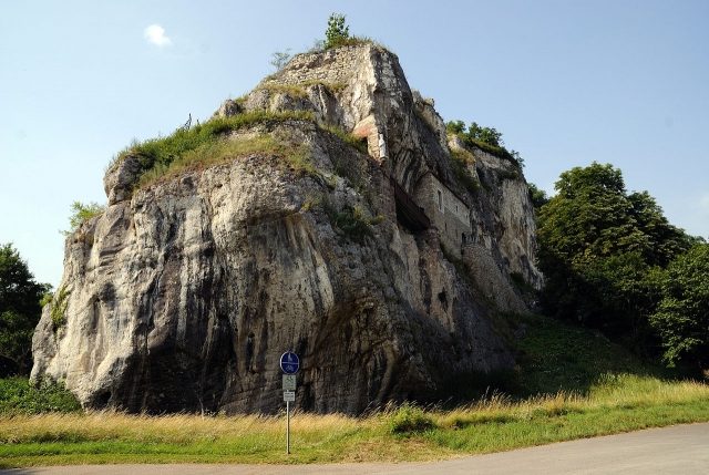
The Isteiner Klotz is a prominent ridge in the Lörrach district in southwestern Germany. The Isteiner Klotz is a promontory between the villages of Istein and Kleinkems, rising about 150 meters above the Rhine floodplains.
At its western end near Istein, the ridge forms a steep cliff. In a rock niche is the Vitus Chapel, built around the year 1100. A circular hiking trail, about three kilometers long, is located on the Klotz.
Geology+
The Isteiner Klotz is an approximately 170 square kilometer zone of Jurassic deposits, wedged between the Rhine Graben and the southern Black Forest. The Isteiner Klotz originally blocked the Rhine's path north, so it first flowed through the Rhone Valley into the Mediterranean Sea.
The Isteiner Klotz in the southern Rhine Valley is a so-called graben fault block made of Upper Jurassic rocks on the eastern shoulder of the Upper Rhine Graben. The oldest (lowest) rocks are Lower Oxfordian clay-marl-marl alternations, the so-called Pholadomya Marls (named after the mussel Pholadomya exaltata), which in appearance correspond to rocks (Argilles à Chailles) of the Swiss and northeastern French Upper Jurassic. Characteristic of the Pholadomya Marls are layers and horizons of limestone nodules. Above these follow reef coral-bearing rocks. After argillaceous coral marls, the approximately 40-meter-thick coral limestone follows, which upwards shows a transition from widely distributed coral reef limestones to scattered smaller reef bodies. The Upper Jurassic sequence of the Isteiner Klotz is concluded by dense micritic limestones (Brachiopod Limestones or Splinter Limestones). The upper boundary of the rock sequence of the Isteiner Klotz is inconsistent and is defined by the onset of bedded, micritic to oncoidal facies types without coral presence. The hanging wall boundary is locally developed as a distinct discontinuity surface.
Stratigraphy: Finds of Cardioceras cordatum in the lowest, chert nodule-bearing Pholadomya Marls place these rocks in the upper Lower Oxfordian. The precise orthostratigraphic classification of the overlying coral limestones is difficult due to the almost complete absence of suitable index fossils. Mainly due to their position above the Pholadomya Marls and isolated finds of Perisphinctes, they are placed in the lower to upper Middle Oxfordian. For the micritic sections directly above the coral limestones, an Upper Oxfordian age may already be conceivable. The rocks are similar in terms of stratigraphy and facies sequence to the Lower to Middle Oxfordian rocks of the neighboring Swiss and French Upper Jurassic. Comparable rocks are also found 20 kilometers south in the area of the Blauen chain of the northern Swiss Jura.
Archaeology+
After initial discoveries in the 1930s/40s, archaeological excavations led by Elisabeth Schmid took place at the Isteiner Klotz, in the Kleinkems area, from 1951 to 1953 and in 1956, providing the first evidence on German soil of Neolithic mining for flint. Further excavations by the University of Basel took place in 2003 and 2004, after which flint mining here occurred mainly around 4200-4100 BC.
Railway+
During the construction of the Rhine Valley Railway in 1846, the planning engineers also had to tackle the Isteiner Klotz, opting for a completely flat but winding route with radii of 400 meters. The railway line, which still exists today, therefore represents a real traffic obstacle, with a maximum speed of 75 km/h allowed on the approximately 15 km long section. Disregarding this speed limit led to the serious Rheinweiler railway accident on July 21, 1971, in which 25 people died near Rheinweiler. On April 1, 2004, another railway accident occurred near the Isteiner Klotz. A vineyard tractor had fallen onto the tracks, causing a collision with an ICE coming towards Basel.
A bypass of the small mountain massif was realized in the Katzenberg Tunnel, which handles long-distance traffic and - especially at night - the larger part of freight traffic. It was put into operation with the timetable change in December 2012.
Fortification Construction+
Due to its exposed location opposite the French border, the Isteiner Klotz has repeatedly been equipped with castles and fortifications. The facilities built between 1902 and 1907 as part of the Upper Rhine fortifications had to be demolished in 1921 due to the provisions of the Treaty of Versailles.
The re-fortification of the Isteiner Klotz as part of the Westwall by the National Socialist rulers began as early as 1936. By the end of World War II, 113 military bunkers were gradually built around Istein. With wall and ceiling thicknesses of up to 3.5 meters, they were considered the most heavily fortified facilities of the entire Westwall on the Upper Rhine. The main facilities were underground in the rock. The individual fighting positions in the rock were connected by a system of over two kilometers of tunnels, stairs, and elevators. On the surface of the Isteiner Klotz, a 105-ton armored dome for artillery observation was built. An almost 56-meter-high staircase led into the dome. The entrances of the comparatively short railway tunnels of the Rhine Valley Railway were equipped with explosive-filled chambers to be blown up if necessary.
After the end of the war, large parts of the fortifications were demolished. The stable, newly built tunnel systems in the two-kilometer-distant hinterland of the Klotz were used by the Bundeswehr as storage facilities until the end of 2005. From 2006, the existing Bundeswehr medical depot was decommissioned, and the above-ground administrative buildings were continued to be used by the Federal Police.
Take Mobile History with you
You are reading this text for free. Premium adds what matters on the road: descriptions read aloud, sites found through your camera, whole regions taken offline.
- Every description, including the ~17,700 Premium sites
- Audio guide: have descriptions read to you on location
- AR finder: see sites through your camera, with distance and bearing
- Unlimited saved sites
14 days free, then from €2.99 a month. Cancel anytime.
Source: Wikipedia · Licence: CC BY-SA 4.0 · Image: http://de.wikipedia.org/wiki/Datei:Isteiner_Klotz.jpg
This description draws on the facts documented in the linked Wikipedia article; Wikipedia content is licensed under CC BY-SA 4.0. Wording and editing: Mobile History.
Location: 47.6615, 7.5303