To be privately owned
ManorModautal-Klein-Bieberau
Hottenbach Manor
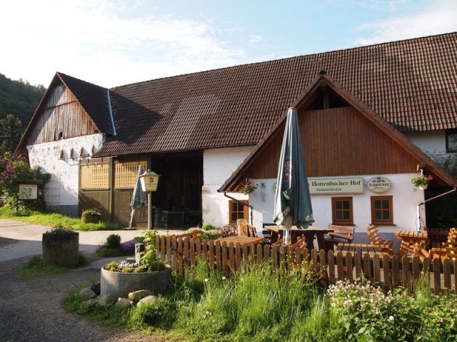
The Hottenbacher Hof is a historic farm estate near the village of Klein-Bieberau in the Odenwald, approximately 16 km southeast of Darmstadt (Hesse).
First Mention+
In 1379, Hof Hottenbach is first mentioned. In the records (of the imperial commission to the Middle Rhenish Imperial Knighthood) concerning Georg Friedrich v. Rodenstein against his guardian and "brother-in-law" Johann Joachim Gambs v. Gottau, son-in-law of the deceased Friedrich Neidhart v. Rodenstein 1663/67, 1683/84 (regarding the surrender of Rodenstein documents, damage to the Rodenstein ancestral estates, etc.), there is a document dated 1379: "Heinrich von Hirschberg sells his share of the village of Hottenbach in the parish of Groß-Bieberau to Adelheid, Helfrich Juden's widow, and her sons Wilhelm and Helfrich."
In 1421/22, the farm is mentioned under the name "Hattenbach" in the income records of Countess Anna von Katzenelnbogen.
The Name and Possible Meaning+
By 1691, the current farm name had become established. Previously, it fluctuated between Hattenbach, Hottenbach, and Huttenbach. It thus belongs to a group of similarly sounding place names in the German-speaking area, which are interpreted as settlements on a stream in a wet or swampy area.
Marginal and Border Location+
Since the last territorial reform in 1971, Hottenbach politically belongs to the municipality of Fischbachtal, postally with Klein-Bieberau to Modautal, and ecclesiastically with Rodau still to Groß-Bieberau.
This overlap of competencies was the fate of the remote small settlement in the border area between the Lordship of Rodenstein and the Upper County of Katzenelnbogen, or since 1479, the Hessian Zent Ober-Ramstadt, throughout the centuries.
Since Hottenbach, along with Neunkirchen, Lützelbach, Brandau, and Steinau, belonged to the Rodenstein office or lower court of Neunkirchen, but at the same time to the Zent Ober-Ramstadt (which became a town in 1310 with the support of the Counts of Katzenelnbogen), conflicts frequently arose, which were also fought out before the Imperial Chamber Court in Speyer.
Already in an arbitration agreement of September 30, 1493, between Landgrave Wilhelm III of Hesse on the one hand and the deceased Erkinger and his cousin Hans von Rodenstein on the other, the Hottenbacher Hof is mentioned twice as a border point. The significance of this arbitration agreement between the Rodensteiners and the Hessians is underlined, on the one hand, by the fact that it only came about through the mediation of Elector Philipp of the Palatinate ("the Sincere"). On the other hand, the fact that the contract was copied multiple times and served as the basis for a map in the 18th century, on which hunting boundaries are drawn and partly color-coded, also emphasizes the document's importance.
Hottenbach also remained an important border point in further history. For example, Hottenbach is found in border descriptions from 1717 and 1723. On September 6, 1759, 20 manorial officials, court lay judges, and field jurors (including the princely Hessian bailiff from Lichtenberg, the princely chief forester from Ernsthofen, court clerks and lay judges from Neunkirchen) surveyed the outer boundaries of Hottenbach to check and re-establish the 65 stones marking the border of the princely domain.
The Hottenbacher Hof is located just under 1.2 km from the center of the village of Klein-Bieberau and lies in the same valley as the village. The road to Klein-Bieberau / Webern is now a dead end, which clearly shows how natural an assignment of the farm to Klein-Bieberau would be. However, while Klein-Bieberau has belonged to the parish of Nieder-Modau since the 14th century, Hottenbach belongs to the parish of Groß-Bieberau. This does not change even when the much closer parish of Niedernhausen is founded on January 1, 1877.
Today+
The farm has been cultivated to this day (with an interruption during the Thirty Years' War).
Take Mobile History with you
You are reading this text for free. Premium adds what matters on the road: descriptions read aloud, sites found through your camera, whole regions taken offline.
- Every description, including the ~17,700 Premium sites
- Audio guide: have descriptions read to you on location
- AR finder: see sites through your camera, with distance and bearing
- Unlimited saved sites
14 days free, then from €2.99 a month. Cancel anytime.
Source: Wikipedia · Licence: CC BY-SA 4.0 · Image: http://www.wehrbauten.de/thread.php?threadid=971
This description draws on the facts documented in the linked Wikipedia article; Wikipedia content is licensed under CC BY-SA 4.0. Wording and editing: Mobile History.
Location: 49.7620, 8.7818