To be privately owned
ManorKöln
Stüttgenhof Manor (Köln)
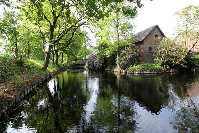
The Stüttgenhof is one of the oldest farmsteads in Cologne and has been a protected monument since 1989. It is also one of the few large Cologne manor houses, parts of whose old building fabric and layout have been preserved, and where agriculture is still practiced by the owners themselves.
Location and Surroundings+
The farm is located in the Junkersdorf area, on the west side of the Stüttgenweg, named after it, which runs between Dürener Straße and Gleueler Straße. This road here borders the district of Cologne-Lindenthal, as well as the city's outer green belt to the west.
Near the farm runs the Frechener Bach, which already fed the medieval moat, as well as fish ponds of the farm via a supply line, and whose water is still used when needed. The course of the stream, whose formerly abundant water quantities still supplied the pond of the nearby Cologne City Forest, newly laid out by Adolf Kowallek, at the end of the 19th century, never reached the Rhine. It has been renaturalized as part of the Regionale 2010 project. Also through this project, an extension of the outer green belt is being created near the farm (behind the KVB railway line), whose facilities will comprise a new forest of 40,000 m² through the planting of about 17,000 young trees of various species. This is being realized on an area previously used for agriculture, which formerly belonged to the lands of the old Krieler Hofgüter, such as that of the Stüttgenhof.
Early Settlement Traces
The history of the farmstead, which is still partly surrounded by a moat today, goes back a long way. The farm, first mentioned in documents in 1271, is located in an area where archaeological investigations have proven a settlement history reaching back to the Neolithic Age.
Settlement Site of the Linear Pottery Culture
The systematic archaeological-topographical explorations of the city area, begun by Fritz Fremersdorf in the 1920s/30s, achieved a sensational success for Cologne's archaeological heritage conservation with the uncovering of the "Lindenthaler Dorf", a Stone Age settlement excavated in 1929 on the area between Stüttgenweg and Militärringstraße. The investigation results led the prehistorian Buttler and the archaeologist Haberey to assign the discovered settlement site to the Linear Pottery period.
Settlement Site of the Hunsrück-Eifel Culture
In 1973, the Römisch-Germanisches Museum, in its capacity as the Office for Archaeological Heritage Conservation of the Cologne city area, learned that lands of the Stüttgenhof had passed to Rheinbraun AG, whose plan was to erect a complex administrative building on the acquired site.
The morphological conditions of the terrain documented in the 1930s and the immediate vicinity of the early Neolithic excavation site of the "Lindenthaler Dorf" prompted the office to conduct new soil investigations, during which numerous finds could be uncovered and recovered. The findings obtained through trench excavations south of Dürener Straße and northeast of Stüttgenhof confirmed a continuation of the early Neolithic culture of the pre-war excavation site only 300 meters away. The finds now proved a settlement site that archaeologists assigned to the Hunsrück-Eifel Culture, a regional Iron Age cultural group of the Middle Rhine region, which lasted from about the end of the 7th century BC to around 250 BC.
Roman Settlement
This period was soon followed by the Romans, whose "granary" became the western foreland of their Colonia. They also left numerous traces, as many finds from this area prove. They created large estates and practiced extensive agriculture, which was later continued by the owners of the "Villa Stute" and by the subsequent owners of the Stüttgenhof until the advent of artificial fertilization.
Interpretation of the Name
The oldest documents of the Stüttgenhof refer to it by the name "zum Stuytgen" but also "zom Stuitgin", a form of designation that was common in the Ripuarian language area. The names are derived from Germanic origin, the Anglo-Saxon and Low German word "stôd", as well as the Middle High German "stuod", which in these variants denote a horse paddock.
The connection of such a farm name is seen in herds of wild and semi-wild horses that existed in the left-bank Rhine area during the Frankish period until the early Middle Ages, and the farms that caught and penned the horses to slowly domesticate them.
From Manor to Private Estate
The "Villa Stute", in the possession of the Teutonic Order Commandery of St. Katharina in Cologne (later Commandery Jungen-Biesen) in 1271, was the namesake of today's Stüttgenhof estate and the street Stüttgenweg named after it.
In 1336, the estate was then in the possession of the Cologne patrician and mayor family Jude. At this time, Knight Göbel Jude and his wife Elisabeth Hardefust bequeathed the Stüttgenhof estate to their daughter Imagenia, who brought it into her marriage with "Johann von Spiegel zum Irgang" as a bridal gift from her parents. The ownership of the estate changed several times thereafter until it again became the property of the Hardefust family. However, the lands were sold, with one part passing into the possession of Brauweiler Abbey (which kept it until secularization under French rule) and the other part with the farm being acquired by the Knights of Fischenich.
Daem von Fischenich had the farm managed until the 15th century, but for financial reasons was forced to sell it in 1485. The new owner of the property was now the Cologne Collegiate Church of St. Gereon, under which the estate was granted as a regular knight's fief. For this period, the land belonging to the Collegiate Church of Stüttgenhof was stated to have an area of three Mansen.
Usage Rights of the Gereon Collegiate Church
Since early times, the Stüttgenhof was equipped with waters, which were ensured by a supply line from a stream flowing down from Frechen and brought manifold benefits. These included drinking water supply for humans and livestock and feeding the moat. Furthermore, pond systems had been created, which served for fish farming, but later also for bathing cures of visiting ecclesiastical gentlemen of the St. Gereon Collegiate Church. This specifically mentioned right of use at Stüttgen apparently remained with the Collegiate Church until secularization, as it was still mentioned in 1761 in documents, in which the canon of the Collegiate Church and later cathedral dean, Hermann Werner von Bossart, is listed as having been granted the rights to the "Tusculanum Stüttgen".
Tusculanum Stüttgen
Already in the 16th century, but at the latest after the decisions of the Council of Trent (1545 – 1563), internal church details were regulated, which included, for example, an individual's entitlement to leave within the clergy.
However, this humane achievement, which meant the granting of an annual leave of a total of six weeks, spread only slowly and only began to gain acceptance in the 17th century. It was then also introduced in Cologne collegiate churches and later became normal. At St. Gereon, it was decided in 1628 to follow the example of other collegiate churches and, also following the suggestions of the Tridentine Council, to grant their own clerics this vacation period.
Initially, the ecclesiastical gentlemen concerned of the Archdiocese of Cologne traveled for bathing cures to relatively nearby places such as Aachen, Ems, Spa, Schwalbach or St. Tönnis. Later, they remembered the possibility of using their own lands, which they prepared accordingly and subsequently used as at Stüttgen. It was called Tusculanum.
Parish of Kriel
At the latest since the acquisition of the farm by the St. Gereon Collegiate Church, it, like the hamlets of Kriel, Lind, and the farms there such as the Kitschburg estate, the Kriel farm, and the Platzhof, the Decksteiner- and Palanterhof, the Hohenlind manor, and the Mönchshof and Kleijohanshof, belonged to the parish of Kriel.
For the people living on the Stüttgenhof, this meant that attending church services involved a walk of several kilometers to the parish church of Krieler Dom. The same applied to baptisms, weddings, and funerals, which initially took place in the Krieler churchyard. Remarkable well-preserved tombstones from the 16th to 18th centuries can still be found there today, including examples erected for deceased residents of the Stüttgenhof. Later, their final resting place was the municipal cemetery on Decksteiner Straße, opened in 1869, which was used until 1917 and is now a park.
From 1688, the Stüttgenhof was leased by the Collegiate Church to civilian tenants, and for the year 1761, the records of the Gereon Collegiate Church report burning farmhouses in Stüttgen. The rear barn wall of the four-sided farm (the transverse building facing Marsdorf) gives cause for corresponding conclusions; it clearly shows a line between the very old and the rising masonry of more recent times (see Commons). In 1802, the Stüttgen estate was also confiscated by the French as spiritual collegiate property. At this time, the farm and the lands, largely located east of Stüttgenweg, covered an area of 95.2 hectares.
Stüttgen Estate in Private Ownership
Initially, the estate was managed by a tenant named Mathias Otten, until it then passed from French to Prussian state ownership. At an auction of state properties in 1821, Adam Ploog, originally from Flittard, was awarded the bid and, with the acquisition of the Stüttgen estate, became the founder of a family business that continues to this day.
Adam Ploog, who probably already had experience in managing an agricultural business as a tenant of the Barons von Fürstenberg, the Rhenish branch of the family, died in 1849 at Hof Stüttgen, where a tombstone with an inscription is still located today. The succession at this time is unclear, however. Of Hilger Ploog, also born in Flittard, it says on the tombstone at Krieler Dom "the wealthy gentleman ......, pensioner of single status (1812 – 1860) died at Stüttgerhof". Another family tombstone, now in the Decksteiner cemetery, gives the life data of a Friedrich Ploog as 1860 to 1890. In the literature on Stüttgenhof, it is stated that the farm was leased out at the end of the 19th century.
Changes at the Turn of the Century
The incorporation of areas of the mayoralties of Efferen and Müngersdorf into the city of Cologne in 1888 only insignificantly changed the daily lives of the residents in the former rural community of Kriel. The building boom that began in the middle of the 19th century prompted many farmers to sell their lands in the urban area. The sold plots with their rich clay soils were exploited for brick production and thus became later land usable only for construction. The areas of the farms located on the periphery of the emerging suburb remained untouched by this. Until the 1980s/90s, the Kriel estate, the Platzhof, and a homestead belonging to Kitschburg, as well as the still managed Stüttgenhof, remained.
Probably after the expiry of the lease agreements, the "von Meer" family, likely descendants of the Ploog family through marriage, took over the management of the estate as owners in the 1930s.
Known Construction Measures
The history of the property, which is quite well documented regarding frequent changes of ownership, reveals little data concerning structural changes. The spry senior of the von Meer family, born in 1920, stated that the property acquired by Adam Ploog was still completely surrounded by a moat. He further stated that the foundation area of the southeastern front house, consisting of field-fired bricks, is very old due to its porous condition, and probably belongs to a construction phase of the 18th century. The plinth walls of the western farm building are also said to be of older origin, their parts built up to raise the roof clearly stand out from the original masonry. Other parts of the buildings were rebuilt or newly constructed in 1890 and from 1930. Between these years, the brick house on Stüttgenweg, now a monument, was probably built; it is located about 50 meters south of the farm and probably served as a servant's house.
The residents obtained their drinking water from a well made of brick, driven 14 to 16 meters into the earth. The shaft in front of the manor house, from which water was last drawn with a hand pump, has been decommissioned since the post-war period.
Current Farmstead+
Even after the land sale to Rheinbraun AG in the 1960s/70s, the Stüttgenhof estate retained sufficient land. It is currently equipped with modern machinery appropriate for today's agricultural technology, ensuring the continued economic viability of the family business. In contrast to many farms converted into residential complexes, the Stüttgenhof is still exclusively inhabited by the family (The senior of the family, Werner von Meer, passed away in April 2012 at the age of almost 92.). The farmstead has been protected as a monument of the state of North Rhine-Westphalia since March 3, 1989.
Transport Connection
Stüttgenweg is accessible by car exclusively via Dürener Straße, Federal Highway 264. North of the Cologne-Marsdorf district, the Frechen junction of Federal Highway 1 and Federal Highway 4 is located on this road.
As a result of the new construction of the Cologne RWE administration buildings on the Lindenthal-facing side of Stüttgenweg, the formerly secluded farm also received a tram station for line 7, which runs between Cologne-Porz and Frechen, at a distance of approximately 200 meters.
Take Mobile History with you
You are reading this text for free. Premium adds what matters on the road: descriptions read aloud, sites found through your camera, whole regions taken offline.
- Every description, including the ~17,700 Premium sites
- Audio guide: have descriptions read to you on location
- AR finder: see sites through your camera, with distance and bearing
- Unlimited saved sites
14 days free, then from €2.99 a month. Cancel anytime.
Source: Wikipedia · Licence: CC BY-SA 4.0
This description draws on the facts documented in the linked Wikipedia article; Wikipedia content is licensed under CC BY-SA 4.0. Wording and editing: Mobile History.
Location: 50.9217, 6.8751