To be privately owned
ManorMunich
Moosschwaige Manor
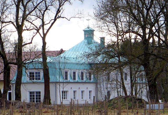
The Moosschwaige is a secluded estate in the west of Munich. The estate is a protected building ensemble, and the residential building and chapel are also protected as individual monuments.
The Moosschwaige is located on the western border of Munich in the southwest of the Aubing district, in district 22 Aubing-Lochhausen-Langwied, at Germeringer Weg 250. It forms the only development in southern Aubing west of the A 99 motorway ring.
The Moosschwaige was first mentioned in documents in 1808 or 1812 as Mos Schweige. The name means "Schwaige", i.e., cattle farm, in the moor, the Aubinger Moos. The Schwaige belonged to the Freiham estate located to the southeast.
In 1818, the Schwaige became part of the newly established municipality of Aubing, with which it was incorporated into Munich in 1942.
Description+
The Schwaige is a four-sided farm from the 19th century. Four buildings surround a rectangular courtyard. The residential building is located in the northwest of the courtyard, a stable in the northeast and southwest respectively, and a barn in the southeast. Access to the Schwaige is via an avenue from the east.
The central building of the residential building is a two-story cubic pavilion with a tent roof and a roof turret. Two unequal side wings adjoin it. The pavilion dates from the first half of the 19th century, the side wings are younger.
The stables, a horse stable and a cow stable, are single-story, elongated buildings with saddle roofs, whose ground floors have Prussian vaulted ceilings. They date from around 1900, the barn closing off the courtyard to the south is younger.
Near the junction of the avenue into the courtyard stands a small chapel. It is a saddle-roofed building with openings with segmental arches on three sides. The openings are secured by grilles.
The Moosschwaige is one of the last testimonies of such farmsteads characterized by a secluded location and connection by an avenue.
Surroundings+
The meadows at the Moosschwaige form the source area of the Erlbach stream. North of the estate, it flows through some former fish ponds. The area around the fish ponds is protected as a biotope under landscape protection. The orchard meadows of the estate form another biotope.
In 2004, the city of Munich acquired the agricultural and forestry areas of the estate to use them as ecological compensation areas within the framework of an eco-account, but not the farmstead itself.
Take Mobile History with you
You are reading this text for free. Premium adds what matters on the road: descriptions read aloud, sites found through your camera, whole regions taken offline.
- Every description, including the ~17,700 Premium sites
- Audio guide: have descriptions read to you on location
- AR finder: see sites through your camera, with distance and bearing
- Unlimited saved sites
14 days free, then from €2.99 a month. Cancel anytime.
Source: Wikipedia · Licence: CC BY-SA 4.0
This description draws on the facts documented in the linked Wikipedia article; Wikipedia content is licensed under CC BY-SA 4.0. Wording and editing: Mobile History.
Location: 48.1508, 11.3853