Restaurant
Cultural center
CastleScheßlitz
Giechburg Castle
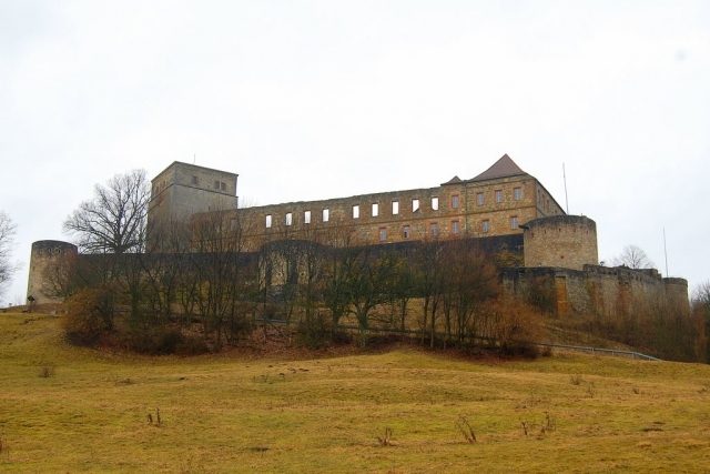
Giechburg, also known as Burg Giech, is a castle ruin in the municipality of Scheßlitz in the district of Bamberg, Bavaria. Giechburg is also a district of the city of Scheßlitz.
Early History
Settlement on the Giechburg plateau can be traced back to the Neolithic period, with a particular intensification of settlement activity during the Celtic period between 500 BC and the birth of Christ. Below the castle, near Demmelsdorf, a tumulus field from the late Hallstatt period was found. In a burial chamber, a chariot burial of a Celtic princess was discovered with numerous pieces of jewelry, including a golden spiral ring and an amber bead, as well as pottery.
Continuous use of the prehistoric fortifications is also likely during the Migration Period.
Medieval Castle Complex
The construction of the medieval castle took place under the powerful Counts of Schweinfurt, presumably around the time of the devastating Hungarian invasions in the 10th century. For this purpose, the western third of the plateau was separated by a deep neck ditch, with the remaining fortifications continuing to exist until the 12th century (munitiones ante castrum sitam).
The castle henceforth served as a link between the royal courts of Hallstadt and Königsfeld on the Jura heights. The first documented mention of the castle dates from 1125 in a deed of gift from Bishop Otto I the Saint, in which Wilhelm von Lützelburg, second husband of Margravine Mechthilde von Meißen, appears as a witness under the name Willehalm, liber homo de giche. Their daughter from her first marriage, Adela von Beichlingen, married Count Reginboto of Wertheim, who held a high office at the Bamberg court and, after his marriage, called himself comes de gicheburc after his acquired property. In 1137, Chuniza, his only child, brought the Giech inheritance to the Andechs comital house through marriage. In 1142, the marriage was dissolved, and Chuniza bequeathed her inheritance to the Prince-Bishopric of Bamberg. However, the count succeeded in enforcing the enfeoffment of the entire property by force of arms.
Succession Dispute
After the death of the last Duke Otto II of Andechs-Merania in 1248, a years-long, grueling succession dispute followed, which ended with the acquisition of Giech Castle and its surrounding area, which comprised approximately the size of the eastern district of Bamberg, by the Truhendingen comital house, related to the Meranians. It remained there until 1390, when Bishop Lamprecht von Brunn finally succeeded in buying the original fief from the heavily indebted counts for a large sum.
Under the aegis of the Bamberg bishops, the neglected castle underwent a formidable expansion, so that during the feared Hussite invasions it was considered the safest place in the entire Prince-Bishopric. Under Friedrich III von Aufseß, the cathedral treasury was brought here, and part of the cathedral chapter also sought safety here. The cathedral treasury remained well-preserved here until after the time of the Bamberg Immunity Dispute, while the surrounding villages and the neighboring Gügelburg were devastated by the Hussites.
Peasant Uprising
During the peasant uprisings of 1525, a delegation of peasants succeeded in taking the castle by deception and setting it on fire, without, however, endangering the substance of the castle. It was not until 1553 that the castle was abandoned after several days of siege by the troops of Margrave Albrecht Alcibiades and, on his command, plundered and set on fire.
Reconstruction of the Castle as a Renaissance Palace
With the reign of Prince-Bishop Johann Philipp von Gebsattel (1599-1609), the ruined castle was rebuilt as a Renaissance palace, incorporating the medieval fortifications, and lavishly furnished. However, it had lost its military significance: the fortresses of Kronach and Forchheim, built after the French model, henceforth took over this function. Giech Palace now served as the administrative seat of the Giech district and as a location for the annual hunting excursions of the prince-bishops. It remained completely undisturbed during the Thirty Years' War, while not a single house remained standing in Scheßlitz.
When the administrative seat was moved to Scheßlitz with the reconstruction of the official buildings there, the palace only functioned as the center for the prince-bishop's foal breeding. When this was also moved to the newly built foal farm in Peulendorf, the palace became the official residence of a forest official, who was also responsible for fire monitoring of the entire surrounding area. The maintenance of the facilities was limited to the bare necessities; decay began.
Mystery of an Iron Basket
An iron basket hangs on the tower of Bamberg's Altenburg, which was formerly used to transmit fire signals to Giechburg, 20 kilometers from Bamberg. A similar facility is not detectable at Giechburg and is not mentioned in the building expenditures of the Prince-Bishop's Treasury Office nor in other documented historical events. Since the practical benefit of such a facility also appears highly doubtful, this is most likely a romanticizing attribute for the Altenburg, rebuilt in the Historicist style in the 19th century.
Recent History
With the secularization of the Prince-Bishopric, the properties around the castle were sold separately. After Hohenhausen's barbaric demolition measures in 1809, which rapidly accelerated an initiated process of decay, the structural condition of the castle became increasingly desolate. In 1819, Count Friedrich Karl Herrmann von Giech zu Thurnau acquired the castle from the Kingdom of Bavaria, without any fundamental changes. In 1932, the last Count of Giech sold the castle to Leonhard Schmaus, a postal employee, whose grandson sold the property in 1962 to Friedrich Karl Hohmann.
In his travel guide about Bamberg and its surroundings from around 1912, the author Dietrich Amende also describes the city of Scheßlitz:
The Castle Today+
To secure the continued existence of the facilities, the "Förderkreis der Freunde der Giechburg e. V." (Circle of Friends of Giechburg) was founded in 1967, and initial significant renovation work was initiated. With the takeover of the castle complex by the Bamberg district in 1971, the association dissolved, and under the care of the district administration, a comprehensive renovation program and the expansion as a conference venue and cultural event center for the Bamberg district began. In addition, the castle offers catering services and accommodation options.
Description of Location and Construction+
The castle is located on the western end of a rocky Jura ridge in a spur position, visible from afar above the valley. The third section of the plateau in the east of the ridge marks the location of an episcopal counter-castle from the first half of the 12th century. This bishop's house probably fell victim to the warlike conflicts during the Meranian inheritance dispute. Three ditches are visible in the terrain on the mountain plateau. The smaller partial area between the built-up areas was contractually secured as an area to be kept free of any construction. A small remnant of a rampart is still recognizable on the eastern edge of the plateau, which was settled over its entire area in prehistoric and early historical times. From the high medieval castle, the lower part of the keep and a section of wall under the former several-meter-thick and approximately five-meter-high eastern shield wall have been preserved, as has most of the curtain wall, which was forcibly supplemented and reinforced after the castle was taken over by the Bamberg Prince-Bishopric in 1390. The castle was thereafter considered so defensible that the Bamberg cathedral treasury was brought here for safety during the threats of the Hussite period and the Bamberg Immunity Dispute. The medieval residential and economic buildings were destroyed in 1553.
The core castle in its present form dates back to the construction activity of Prince-Bishop Johann Philipp von Gebsattel in the years 1602 to 1609. The two wings in the south and west have since been modernized and are used as a castle restaurant and conference venue for the district administration. The long north wing with its numerous window openings has been in ruins in two sections since the early 19th century. To the east, a round, also ruined, stair tower projects from the masonry. Only a two-story oriel window on the west side of the courtyard above the cellar entrance, crowned by a simple Renaissance volute gable, is well preserved. Next to it is the approximately 40-meter-deep well, dug after 1390. The narrow wing in the south also originates from Gebsattel's three-wing complex and once housed the castle chapel as well as the stables, partly built in half-timbered construction, which have also disappeared. A formerly existing second upper floor had to be completely removed at the beginning of the 20th century due to dilapidation. This cavalier building, attributed to Prince-Bishop Marquard Sebastian von Stauffenberg in some publications, is based on a report by the court chamber councilor von Roppelt, who wrote it in 1785, i.e., about a hundred years later. There are no indications for this in the existing building accounts of the Treasury Office, nor was there any reason for such a building project at that time.
The mighty square keep (12.5 x 12.5 meters) stands freely in the eastern castle area. The large tower is set diagonally, thus offering less attack surface to medieval catapults and throwing machines. The plinth area still shows in parts the small-scale ashlar masonry of the high medieval castle complex. Originally probably - like the shield wall in front of it - completed by a half-timbered structure, there was a barrel vault in the basement, and in one of the upper floors, the fireplace system for a heated tower room is still preserved. The only high entrance existing in the High Middle Ages is on the northeast side. The round-arched portal at ground level was newly created during the reconstruction phase of the Gebsattel period, as was the access on the west side, which connected the north wing, housing the prince-bishop's chambers on the upper floor, with the keep via a covered wooden bridge. The slightly recessed, rectangularly windowed upper floor also dates from this period. The keep was formerly covered with a slate-covered Welsche Haube (onion dome).
Originally, one entered the castle area through the vanished Outer Gate at the beginning of the western defensive wall, which also included a gatehouse. A window opening still indicates this. The Gothic or Middle Gate in the west is fronted by the formerly embrasure-fortified Outer Zwinger on the castle side. On the northwest bastion between the two gates, there was formerly a coat of arms stone of Bishop Friedrich III von Aufseß (1421–1431). Above the archway of the middle gate, one can see the coats of arms of Bishops Anton von Rotenhan (1431–1459) and Georg I von Schaumberg (1459–1475). Behind it lies the Inner Zwinger with the former gatekeeper's passage on the back of the vanished embrasure wall to the northwest tower. Above the rusticated portal of the adjoining main gate, a sandstone tablet with the coat of arms of Bishop Johann Philipp von Gebsattel (1599–1609) is embedded. Any relocation of the castle entrance from the east of the castle to the west part goes back to an idea of the castle researcher Hellmut Kunstmann, but is neither proven by the existing building accounts nor was there ever any reason to question the security of the castle by an access in the endangered area of the level plateau in the east. The eastern part of the castle was sealed off from the beginning by the high shield wall and the keep.
Take Mobile History with you
You are reading this text for free. Premium adds what matters on the road: descriptions read aloud, sites found through your camera, whole regions taken offline.
- Every description, including the ~17,700 Premium sites
- Audio guide: have descriptions read to you on location
- AR finder: see sites through your camera, with distance and bearing
- Unlimited saved sites
14 days free, then from €2.99 a month. Cancel anytime.
Source: Wikipedia · Licence: CC BY-SA 4.0 · Image: Maciek Wegrzyn
This description draws on the facts documented in the linked Wikipedia article; Wikipedia content is licensed under CC BY-SA 4.0. Wording and editing: Mobile History.
Location: 49.9550, 11.0494