The Fort can be visited
FortressDoornenburg
Fort Pannerden
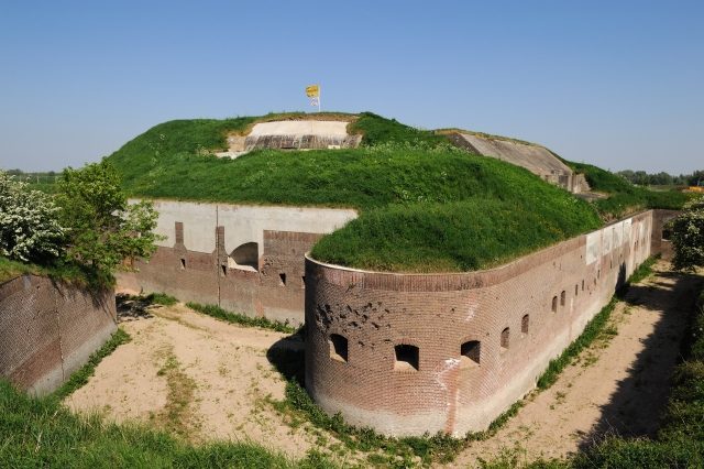
Fort Pannerden, one of the largest fortifications in the Netherlands, rises prominently in the province of Gelderland. This impressive structure was strategically built at the fork of the Pannerdensch Kanaal and the Waal to protect the country's vital waterline.
History+
Between 1869 and 1872, Fort Pannerden was constructed as a barrier against invading troops intending to advance via the Rhine and Waal to the Fortress Holland. It was also designed to prevent the Pannerdensch Kanaal from being dammed, which would have left the Nieuwe Hollandse Waterlinie without sufficient water. However, it soon became apparent that the fort was not equipped to handle the rapid advancements in weaponry, particularly rifled gun barrels and explosive shells. The Prussian river vessels “Rhein” and “Mosel,” with their 15 cm guns, also posed a serious threat. Consequently, the fort underwent extensive modernization from 1885 to 1890. The eastward-facing main battery received armored pillars from Gruson Magdeburg, wrought iron blocks from Peine, and French armor plates. It was equipped with five 15 cm Krupp guns on hydraulic carriages. Two smaller side batteries with Dutch 10 cm hard bronze cannons were also newly built. During World War I, the fort was fully garrisoned, but apart from isolated shots at stray zeppelins and aircraft, no combat occurred. Between the world wars, it was guarded by a sergeant and his family. In World War II, the fort did not play a decisive role, as the attack did not come by water, and no attempts were made to dam the canal. Despite firing a machine gun at aircraft, the fort, which lacked anti-aircraft equipment, had to surrender in the face of superior German artillery and threatened bombardment. After the war, parts of the fort were used as building material, the site as a landfill, and the building as an ammunition storage facility. In 1959, it was declassified. In 1988, the state forest management took over the fort. After an occupation in 2000 and a subsequent eviction, it was integrated into the Nieuwe Hollandse Waterlinie project in 2005. An agreement in December 2006 allowed former occupiers to serve as guards and guides, though not to reside there permanently.
Location+
Fort Pannerden is located in Doornenburg, in the province of Gelderland in the Oost-Nederland region, Netherlands. It is situated at an elevation of approximately 10 meters above sea level.
On site+
Visitors can explore Fort Pannerden today and discover the historic complex.
Nearby+
- Kasteel Doornenburg (castle), approx. 2.4 km away
- Huis Aerdt (manor house and estate), approx. 5.1 km away
- Huis Loowaard (manor house and estate), approx. 5.3 km away
- Haus Keeken (castle), approx. 5.5 km away
Take Mobile History with you
You are reading this text for free. Premium adds what matters on the road: descriptions read aloud, sites found through your camera, whole regions taken offline.
- Every description, including the ~17,700 Premium sites
- Audio guide: have descriptions read to you on location
- AR finder: see sites through your camera, with distance and bearing
- Unlimited saved sites
14 days free, then from €2.99 a month. Cancel anytime.
Source: Wikipedia · Licence: CC BY-SA 4.0
This description draws on the facts documented in the linked Wikipedia article; Wikipedia content is licensed under CC BY-SA 4.0. Wording and editing: Mobile History.
Location: 51.8809, 6.0266