The Fort can be visited
FortressPort-Cros
Fort du Moulin
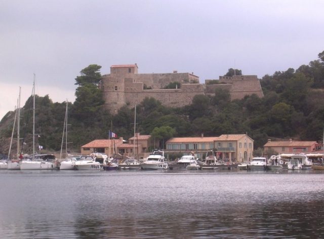
Fort du Moulin, also known as Port-Cros Castle, is a French military structure located on the island of Port-Cros (Var). It was built in the 16th century and subsequently transformed several times.
History of the fort+
The fort takes its name from the old windmill that once stood below it. It was built, at the instigation of Francis I, to combat piracy that was rampant in the Mediterranean. It was redesigned under Louis XIII by Cardinal Richelieu in 1635, for more residential than military purposes, at the same time as the forts of Estissac, Éminence and Port-Man, in order to form a homogeneous defensive complex. At that time, the fort was permanently inhabited; it served as lodging for the commander and soldiers, but also as a store for artillery and provisions. There was even a bakery for the garrison. The fort was involved in the battle of the king's flute La Baleine against British ships in 1710. On August 4, 1710, Louis de Beaussie, commander of La Baleine, pursued by the English, decided to burn his ship at the foot of Fort du Moulin rather than surrender. In 1793, the fort was taken by the British who blew it up. The central building was destroyed as well as the northwest front of the enclosure. After its recapture, some buildings were restored. A coastal battery was then set up at the foot of the structure. In 1814, the lower battery was armed with two 36-pounder cannons, two 24-pounder cannons, three 18-pounder cannons and one 12-pounder mortar. Fifteen gunners and twenty-five infantrymen then occupied the premises. Around 1815, the fall of the Empire led to the fort being put into dormancy. In 1841, after a proposal from the joint commission for Coastal Armament, the lower battery was equipped with three 30-pounder howitzers, three 22-pounder howitzers and one 32-pounder mortar. The edifice was re-established in 1863 but in 1885, the lower battery was decommissioned in favor of Fort de l'Eminence. In 1988, the building was definitively assigned to the Port-Cros National Park. Between 2016 and 2021, the fort underwent a major restoration phase, respecting the architectural style and traditional construction techniques. The stones used were all collected on the island. A so-called flush coating, slightly more covering than a stone-view coating, was then applied to the facades to consolidate the whole. The only structure on the island classified as a historical monument, Fort du Moulin is partly leased to a private individual and is not open to the public.
Description of the enclosure walls+
The outer enclosure of Fort du Moulin is built using the "cut schist" technique. The schists, omnipresent on the island, were used there like bricks. This technique known as "cut schist" appeared in French forts in the 19th century and is always accompanied by a corner chainage of harder stone. The very thick coating was intended to absorb the impact of cannonballs.
Notes and references+
See also+
Related articles+
Port-Cros
External links+
Architectural resources: Inventory Provence-Alpes-Côte d'Azur Mérimée
"Port-Cros Park website" "Park Atlas"(Archive.org • Wikiwix • Google • What to do?) "French National Parks website" (en) "Park sheet on the UNEP-WCMC website"(Archive.org • Wikiwix • Google • What to do?) Portal of French historical monuments Portal of military history Portal of Hyères
Take Mobile History with you
You are reading this text for free. Premium adds what matters on the road: descriptions read aloud, sites found through your camera, whole regions taken offline.
- Every description, including the ~17,700 Premium sites
- Audio guide: have descriptions read to you on location
- AR finder: see sites through your camera, with distance and bearing
- Unlimited saved sites
14 days free, then from €2.99 a month. Cancel anytime.
Source: Wikipedia · Licence: CC BY-SA 4.0 · Image: http://commons.wikimedia.org/wiki/File:2008_Port_Cros_Fort_du_Moulin.JPG?uselang=fr
This description draws on the facts documented in the linked Wikipedia article; Wikipedia content is licensed under CC BY-SA 4.0. Wording and editing: Mobile History.
Location: 43.0107, 6.3813