The Fortress can be visited
FortressWillemstad
Willemstad Fortress
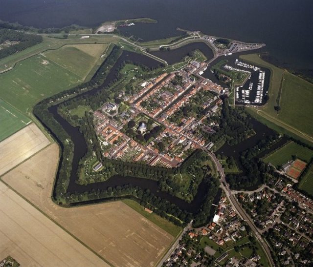
In 1561, Jan IV van Lymes, Marquis of Bergen op Zoom, commissioned the drainage of the salt marshes in the extreme north-west of his marquisate. The polder was completed in 1564 and was named the Ruygenhil. One year later, a village was built, which was also given the name Ruygenhil. When the successor to the Marquis, Jan van Wittem, openly sided with the Spaniards in 1581, the Council of Brabant decided to give the area to Willem van Oranje as compensation for his losses during the Eighty Years’ War. Based on its strategic location, Willem van Oranje decided to turn the village into a fortified town. This was initiated in 1583 and the name changed from Ruygenhil to Willems’ stad.
Willem van Oranje did not live to see the completion of the fortress. He was killed on 10th July 1584 in Delft. His son, Prince Maurits, completed the ramparts and the layout clearly bears his hallmark. In 1586, Prince Maurits granted the city certain privileges. Prince Maurits financed the construction of three important buildings in Willemstad. In 1587, the Town Hall was built next to the harbour. The Koepelkerk dates from 1607 and the Princehof, now known as the Mauritshuis, from 1623.
The seven bastions, named after different regions, remind us of exciting moments in history. One of these was Napoleon’s visit to Willemstad, when he commissioned a building on the Utrecht bastion to store gunpowder (kruithuis). Other bastions hold relics from the First and Second World Wars. In 1926, Willemstad lost its status as garrison town and fortified city. In 1970, Willemstad was declared to be a national heritage site. It is one of the most beautiful preserved fortified cities in our country.
Take Mobile History with you
You are reading this text for free. Premium adds what matters on the road: descriptions read aloud, sites found through your camera, whole regions taken offline.
- Every description, including the ~17,700 Premium sites
- Audio guide: have descriptions read to you on location
- AR finder: see sites through your camera, with distance and bearing
- Unlimited saved sites
14 days free, then from €2.99 a month. Cancel anytime.
Source: Wikipedia · Licence: CC BY-SA 4.0
This description draws on the facts documented in the linked Wikipedia article; Wikipedia content is licensed under CC BY-SA 4.0. Wording and editing: Mobile History.
Location: 51.6920, 4.4380