The Fortress can be visited
FortressLandau
Fortress Landau
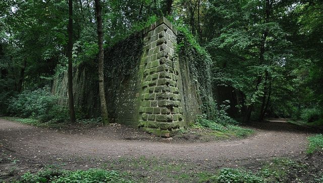
The Fortress of Landau was a polygonal fortress in Landau in the Palatinate. Construction work took place between 1688 and 1691. In 1871, the fortress was razed after the completely outdated fortress was declared a depot in 1867. Only a few buildings in the city and the walls of the fort have been preserved.
History of the Fortress+
After the Thirty Years' War, the Imperial City of Landau was placed under the protection of France from 1648 by the Peace of Westphalia. After the end of the War of the Palatine Succession in 1697, the city, along with ten other Alsatian imperial cities, was legally assigned to France in the Treaty of Rijswijk in 1697. As France's outermost eastern outpost, this location therefore held great significance. In 1688, King Louis XIV ordered the fortress builder Marshal Vauban to transform Landau into a modern fortress. The old city walls were demolished, and with the help of sixteen royal battalions under the command of General Montclar and about 14,000 construction workers from the surrounding area, the reconstruction began in the spring of 1688, which was completed after three years. To supply the construction site with building materials, the 7 km long, navigable Albersweiler Canal had previously been built between the quarries near Albersweiler and Landau. During the reconstruction, straight, wide streets and squares were created for troop formations. In 1700, Engineer Colonel Jacques Tarade built a crownwork on the hill to the northwest, which additionally protected the fortress from this side. In 1702, the garrison of the Landau fortress consisted of 4,095 infantrymen and 240 cavalrymen.
During the War of the Spanish Succession, a total of four sieges of Landau took place between 1702 and 1713, each time the fortress falling to the besieger. Thus, in 1702 the fortress was handed over to the Imperial forces, in 1703 it fell back to the French after the Battle of Speyerbach, only to go to the Imperial troops again in 1704 and finally fall back to the French in 1713. Further reinforcements took place in 1710, such as the ravelin, also known as the half-moon outwork to the west of the main moat. The fort was further expanded in the years 1740-1742, when, among other things, the mine galleries and the western escape and retreat gate were built. In 1793, during the Coalition Wars, a futile siege of the fortress by Prussian troops followed.
After the fortress remained with France following the First Peace of Paris, on November 3, 1815, the fortress was assigned as a federal fortress to the newly formed German Confederation. The peacetime garrison of the Landau fortress originally consisted of 2800 Bavarians. In case of war, Baden was to provide one third of the wartime garrison, which had grown to a total of 6000 men, at Bavaria's request. After the formation of the reserve infantry division of the federal army, the composition of the garrison contingents of the federal fortress was changed. On March 3, 1831, by decision of the Federal Assembly, it was determined that the wartime garrison of Landau would consist of 4000 Bavarians supplemented by mixed contingents of the reserve division of 2300 men. The governor and commander of the federal fortress of Landau were appointed by Bavaria, as it had been transferred from Austrian to Bavarian jurisdiction in 1816. During the time of the German Confederation, significant expansion work primarily involved the construction of numerous detached outworks, which removed the old city wall from the effective range of enemy artillery.
Structure+
The basic form of the fortress was an elongated octagon, whose corners were formed by seven bastioned towers and a large reduit. All around, the inner area was enclosed by a moat. Through an ingenious lock system, the moat could be flooded if necessary. In front of the moat were the outer works with a covered way. Two gates led into the city; one in the south and one in the north. The fortress was divided into two parts by the river Queich, the left part of which could be effectively protected by flooding the surrounding terrain. Two thirds of the fortress were thus almost impassable for attacking troops due to a wide and deep flood basin. A narrow wooden bridge over the flood basin formed the only connection with the crownwork.
Take Mobile History with you
You are reading this text for free. Premium adds what matters on the road: descriptions read aloud, sites found through your camera, whole regions taken offline.
- Every description, including the ~17,700 Premium sites
- Audio guide: have descriptions read to you on location
- AR finder: see sites through your camera, with distance and bearing
- Unlimited saved sites
14 days free, then from €2.99 a month. Cancel anytime.
Source: Wikipedia · Licence: CC BY-SA 4.0
This description draws on the facts documented in the linked Wikipedia article; Wikipedia content is licensed under CC BY-SA 4.0. Wording and editing: Mobile History.
Location: 49.2034, 8.1064