The Fortress can be visited
FortressKoblenz-Asterstein
Fortress Koblenz-Fort Asterstein
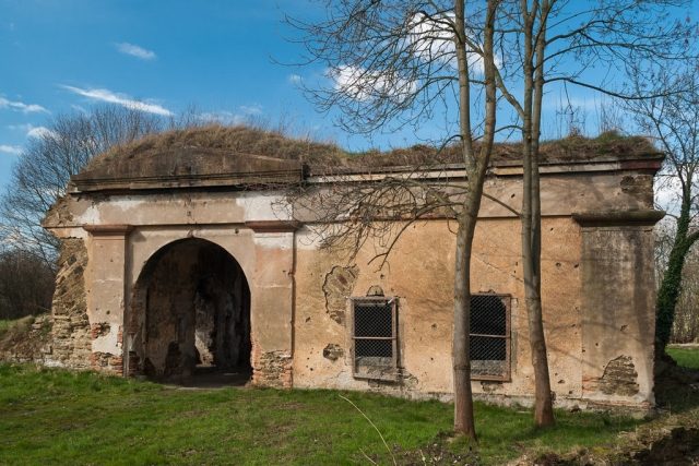
Fort Asterstein was part of the Prussian Fortress of Koblenz and belonged to the Pfaffendorfer Höhe system. Of the fort, built in the 1820s and partially demolished in the 1920s, the reduit is still completely preserved in today's Koblenz district of Asterstein, for which it was named.
Fort Asterstein was built as the main work of the Pfaffendorfer Höhe system, as was the neighboring Ehrenbreitstein Fortress, in a New Prussian manner. The construction period of this structure, located on the right side of the Rhine, falls between 1819 and 1826. The fort received its name in 1847 in honor of the Prussian General Ernst Ludwig von Aster, who had earned merits, among other things, as inspector of the Prussian fortresses in the Rhineland during the construction of the Fortress of Koblenz. In addition to von Aster, the engineer officers Gustav von Rauch, Claudius Franz Le Bauld de Nans, and Gotthilf Benjamin Keibel were involved in the construction. The fort was first occupied by troops in 1830.
Together with other works on the Asterstein, such as Fort Rheinhell, Werk Glockenberg, and Bienhornschanze, which were built during the 19th century, the fort secured the cities of Koblenz and Ehrenbreitstein against bombardment and formed a southern outpost of Ehrenbreitstein Fortress.
The most decisive renovation of the fort took place in 1865, when the rampart in the northeast was extended and a second front was created. In connection with this, the rampart received traverses for cover against flanking fire. In addition, the left flank tower, which attracted enemy fire, was demolished in 1875 and replaced by a low earthwork. Until 1918, the fort was used as a Prussian barracks, after which French occupation troops used the facility until 1929.
Due to the defortification in 1927, in execution of Article 180 of the Treaty of Versailles, and subsequent changes, only the reduit, the gatehouse (whose southwestern casemate was destroyed in a bombing raid in 1943), a part of the left flank of the rampart, and the left flanking work (earthwork) remain of Fort Asterstein. The right flank tower was removed in 1938. The outer works have almost completely disappeared.
From 1941, the reduit was used for newspaper production (until 1945 the National Socialist Nationalblatt and from 1945–1951 the Rhein-Zeitung). After that, the fort was inhabited by Koblenz families until 1971 and was finally left to decay in the following years. From 1996 to 2011, an association took care of the preservation and restoration of the facility. In 2010, the vaults were grouted.
Construction+
Fort Asterstein was built according to the polygonal system, whose rampart was oriented to the south with two obtuse angles. Broken stone of slate and greywacke was used as building material, and red sandstone for edges and architectural elements. The fort consisted of one front and two flanks, after a renovation in 1865, of two fronts and two flanks. The ditch was fronted by a covered way with an underlying counter-mine system. For ditch defense, there was a caponier on the ditch floor in front of the front, as well as positions in the ditch walls, each connected underground to the reduit. A separate gate building led into the courtyard behind the rampart. From the courtyard, ramps led to the gun emplacements, which were covered at the front and, after 1870, also received traverses as lateral covers. Ammunition rooms were built underground.
The two-story, casemated reduit was located at the rear of the fort. It consists of a round structure based on a three-quarter circle (290°) and two traditors of rectangular plan attached to the gorge, which served to secure the gorge. The front of the reduit features gun and rifle embrasures. On the earth-covered roof, there were further gun emplacements behind a parapet wall. The gorge of the reduit was secured by the ditch running around the entire fort, supplemented by a ditch of the reduit, and a drawbridge. The gorge wall is deliberately kept low so that, in the event the enemy had occupied the fort, the guns of the east front of Ehrenbreitstein Fortress could fire into the fort.
The casemates, as was customary in the Fortress of Koblenz and Ehrenbreitstein, were gun emplacements that were also suitable for living purposes and then served as barracks rooms until 1918. (Rhenish Pioneer Regiment No. 30) The cellar rooms served as magazine rooms. Under the right traditor is the cistern, which stored drinking water pumped up from the Blindtal and, from 1866, piped over from the Riddelsorn near Arenberg. From a circular corridor on the ground floor of the round building, mine passages led under the courtyard of the fort, one of which has been uncovered.
The circular plan of the reduit, similar to that of the destroyed Bubenheimer Flesche, is explained by the need to be able to defend this structure, intended as a fallback position behind the fort's rampart, in all directions. From an art historical perspective, the form shows vague references to revolutionary architecture, e.g., to a design for a round prison by August von Voit, which follows the so-called "panoptic" tendencies around 1800 for the design of buildings such as prisons, workhouses, hospitals, etc., with Voit himself taking the type of tower reduit as a model. However, surveillance and confinement of soldiers in the sense of a prison were certainly not intended in Fort Asterstein. Following the principles of the army reform of 1808, the reduit offers an almost cheerful interior view, whose design with rusticated blind arcades and smoothly plastered arched niches shows echoes of baroque facades such as that of the Marstall of Schloss Weißenstein near Pommersfelden. The gatehouse features a round-arched passage and facades with pilasters, simple Tuscan capitals, architrave, and stucco rustication. Together with the two wing buildings and the gatehouse, the complex had a total of 51 living and defensive casemates.
After the destruction of large parts, especially of the rampart and ditch, as a result of the Treaty of Versailles in 1927, only the reduit located at the rear, a three-quarter circular and two-story building with combined gun and living casemates, as well as parts of the main gate to the rampart system, remain of the fort. The earth cover is still present on all structures. Despite the loss of substance and years of decay, the function of the complex can still be clearly recognized in many details. It is the last completely preserved reduit of the Fortress of Koblenz.
Take Mobile History with you
You are reading this text for free. Premium adds what matters on the road: descriptions read aloud, sites found through your camera, whole regions taken offline.
- Every description, including the ~17,700 Premium sites
- Audio guide: have descriptions read to you on location
- AR finder: see sites through your camera, with distance and bearing
- Unlimited saved sites
14 days free, then from €2.99 a month. Cancel anytime.
Source: Wikipedia · Licence: CC BY-SA 4.0 · Image: http://commons.wikimedia.org/wiki/File:Fort_Asterstein_2007.jpg?uselang=de
This description draws on the facts documented in the linked Wikipedia article; Wikipedia content is licensed under CC BY-SA 4.0. Wording and editing: Mobile History.
Location: 50.3549, 7.6155