The remains of the fortress can be visited
FortressKoblenz-Lützel
Fortress Koblenz-Bubenheimer Flesche
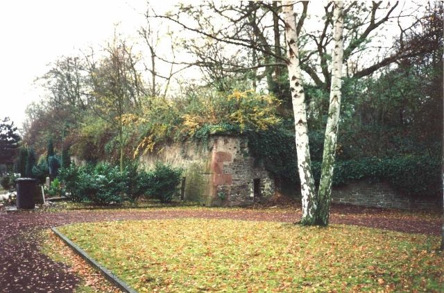
The Bubenheimer Flesche was part of the Prussian Fortress of Koblenz and belonged to the Feste Kaiser Franz system. Of the flesche, completed in 1822 in what is now the Lützel district of Koblenz, only remnants remain after its demolition in 1920 and final destruction in 1969. It is named after the neighboring district of Bubenheim.
The Bubenheimer Flesche was built between 1816/17 and 1822 on the eastern side of Petersberg, an elevation on the left bank of the Moselle, and together with Feste Kaiser Franz formed the core of the system.
Only after 1850 were there major changes and corrections to the work. For example, the rampart was traversed and regulated between 1864 and 1866, and in 1877/78 the collapsed left flank was rebuilt. Along with the other works of the system, the flesche was finally abandoned in 1890. Subsequently, the rampart on the left side was removed and the ditch was filled with earth. Three powder magazines, which had previously stood in the Neuendorfer Feld, then found their place here.
After the First World War, the flesche, like the other Koblenz fortifications, fell under the provisions of Article 180 of the Treaty of Versailles and had to be de-fortified. De-fortification work in Koblenz began at the Bubenheimer Flesche, where the first work took place around mid-July. In preparation for the planned demolition work, the first blasting tests took place here at the beginning of September 1920. The demolition work on the flesche was completed around mid-November 1920. Among the parts that remained were the redoubt and an adjoining mortar battery. The debris from the remaining, blown up and demolished parts remained on site.
On this landscape of ruins, the Lützeler Volkspark was created in the 1930s, incorporating the remains of the fortress. For this purpose, the entire area was leveled and redesigned as part of job creation measures. The redoubt housed a restaurant from 1937, and in 1938 a wintering house for plants was built in the mortar battery.
During the Second World War, the Volkspark became a victim of the bombing war. The reconstruction of the park after 1955 was only in a simplified form. The Lützeler cemetery was created in the lower part, facing the railway. Already in 1953, the restaurant in the only slightly damaged redoubt had reopened its doors. In the 1960s, it was a popular excursion restaurant and a beat club. When the establishment finally closed in 1967, the building initially stood empty. Due to a lack of other usage concepts, the city of Koblenz finally had the redoubt and mortar battery destroyed in 1969, to prevent further decay of the building and the entry of undesirable persons. The remains stayed in the park and were covered with earth, so that today a hill rises at this spot.
The last visible remains of the Bubenheimer Flesche are now located in the Lützeler cemetery. Here, part of the escarpe of the right face and parts of the right flank battery are preserved. Also preserved is the outer wall of the communication to Feste Kaiser Franz, while the passage behind it was rendered unusable by section-by-section blasting as early as 1920. Currently, there are plans to upgrade and redesign the Volkspark by building an observation tower. As part of these plans, the excavation or removal of the remains of the redoubt is also being discussed.
Construction+
The flesche was oriented northwest towards Bubenheim. The surrounding ditch was secured by two caponiers as well as by crenellated escarpe and counterscarp. The right caponier, parts of which are still preserved today, stands almost completely free at the end of the ditch. In the gorge of the work was a redoubt in the form of a three-quarter circle, which was open towards Feste Kaiser Franz. Adjoining it, towards the tip of the flesche, was a mortar battery. The Bubenheimer Flesche was connected to Feste Kaiser Franz by a hollow passage, the so-called communication. This offered sufficient space to move troops and even cannons unseen from one fortification to another. From here, the fortress garrison could also secure the gorge of both works and the terrain between them via embrasures.
Take Mobile History with you
You are reading this text for free. Premium adds what matters on the road: descriptions read aloud, sites found through your camera, whole regions taken offline.
- Every description, including the ~17,700 Premium sites
- Audio guide: have descriptions read to you on location
- AR finder: see sites through your camera, with distance and bearing
- Unlimited saved sites
14 days free, then from €2.99 a month. Cancel anytime.
Source: Wikipedia · Licence: CC BY-SA 4.0 · Image: http://de.wikipedia.org/wiki/Datei:Bubenheimer.jpg
This description draws on the facts documented in the linked Wikipedia article; Wikipedia content is licensed under CC BY-SA 4.0. Wording and editing: Mobile History.
Location: 50.3748, 7.5901