The Fortress can be visited
FortressGermersheim
Fortress Germersheim-Kommandantur
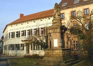
The Germersheim Fortress was a Royal Bavarian fortress in the Palatinate city of Germersheim. It was financed by the German Confederation and was part of a system of fortifications in western Germany to protect against feared French attacks. The Germersheim Fortress was not, as often claimed, a federal fortress. While securing jobs during its construction, which began in 1834 and was completed in 1855 and 1861 respectively, it later hindered urban development and prevented any population growth or industrial settlement. From 1878, the fortress was the location of the 17th Infantry Regiment "Orff" of the Bavarian Army. As a result of the Treaty of Versailles, most of it was demolished between 1920 and 1922; the parts that still exist today are now generally regarded as local cultural heritage.
Background and Construction of the City Fortifications
After the city became French in 1792, the French built new fortifications, which were reinforced in 1814 after being taken over by Bavaria. The German Confederation recognized the importance of Germersheim as a strategically important hub just one year later. In the event of a French attack, troops were to be gathered as quickly as possible along the Luxembourg–Landau–Rastatt line to repel it. Germersheim played an important role as it was the first military central point where the French, whose attack was primarily expected from the south, could cross the Rhine and invade Baden. Furthermore, at that time, the city would have been difficult to retake from the east, where the Rhine formed a natural border, and from the north, as this was pure swampland at the time.
Against this background, initial survey work on the city began as early as 1818, during which a plan to build a fortress based on the polygonal system was drafted, but soon discarded. The final decision of the Federal Assembly to fortify the city was made only in 1832. The elaboration of a plan and the direction of the construction work were entrusted to Friedrich von Schmauß.
On June 30, 1834, the construction of the fortress began with the excavation of the main ditch, and on the anniversary of the Battle of the Nations near Leipzig in the same year, October 18, the foundation stone of the fortress was laid. The actual construction was completed in 1855, but the digging of the mine passages dragged on until 1861; in total, the construction therefore lasted twenty-seven years.
Structure of the Fortress
The main work of the polygonal fortress, in addition to a city wall, was divided into six fronts (from northwest clockwise: Carl, Reuß, Diez, Lamotte, Schmauß and Beckers), to which the advanced front Hertling and some caponiers were added. Furthermore, there were ten advanced defensive structures: The three strongest (Friedrich (the Victorious) in the northeast, Wrede in the east, and Deroy in the southeast) were called outworks (contemporaneously still written -veste); six weaker, so-called redoubts, four of which were on the right bank of the Rhine (from south to north: Zandt, Brückenkopf, Seydewitz and Treuberg) and two (Siebein in the north and Vincenti in the southwest on the Rhine bank) on the left bank of the Rhine; finally, the particularly weak left-bank wing work Ysenburg [] in the northwest was added. There were two entrances to the city, namely the Ludwigstor (originally Deutsches Thor) in the northwest and the Weißenburger Tor (originally Französisches Thor) in the east. Furthermore, the area outside the main wall was almost completely traversed by mine passages. There were originally four barracks, three of which were defensive structures (Stengelkaserne, Seysselkaserne and Theobaldkaserne), as well as the non-defensive (Franciscan) Monastery Barracks. Later, three more (Zollerkaserne, Pontonierkaserne and Maschinengewehrkaserne) were added, so that the number at the end of the fortress's existence amounted to seven barracks.
Main Work
Primarily, the fortress consisted of the 3200 m long city wall, which was divided into six fronts. Its strongest fronts were Fronte Beckers in the west-southwest and Fronte Schmauß in the south-southwest. Both sections were equally long at 490 meters each. Their main works were two-legged ditch defenses, and in front of them, earth walls, about forty meters wide at the base and offset with galleries at the top, rose, in front of which there was again a dry ditch. Next to the walls were oval-shaped redoubts, which were two-story walkable buildings on the front side, but only provided a wall about three meters high with loopholes on the back. From the galleries, posterns in the form of wall traverses led back into the city. These wall traverses also formed the entrances to the casemates of the rear defense gallery. Between these adjacent and identically built fronts was (in front of the main wall and the ditch) Lunette No. 83.
Proceeding further counter-clockwise from Fronte Schmauß, one reaches the 480-meter-long Fronte Lamotte southeast within the main wall, where the Weißenburger Tor was also located. Since, unlike Beckers and Schmauß, it was located towards the Rhine (only about four hundred meters from the bank) and therefore a direct French attack was not expected from this direction, it was weaker, so the ditch defense was only single-legged. From the Weißenburger Tor, a road led over a drawbridge, which led to a country road around the city; this led left north towards Lingenfeld and further to Speyer, to the right south around the city and then further west towards Bellheim–Landau. Two hundred meters southwest of Fronte Lamotte was and is the city cemetery, to which Fronte Hertling, also a lunette, was connected. It was connected to the main work by a tunnel about 280 meters long.
North of Fronte Lamotte was Fronte Diez in the east of the complex, which at only 360 meters was the shortest section of the fortress. Of this, over a total length of 230 meters, the wall was replaced by a single building designed for rifle and artillery defense, which also served as a provincial office magazine, garrison bakery, war mill, and slaughterhouse. Approximately in its middle, this made an almost right-angled bend, accordingly it could also be defended directly without a ditch defense. The bed of the Queich runs through the ditch of the front, from which, in case of defense, the ditch of Fronte Diez, as well as Fronte Reuß and parts of Fronte Carl, could have been flooded by damming.
The northeast of the main wall was dominated by the 530-meter-long Fronte Reuß. It was the weakest part of the fortress, as it was the last to offer a potential attack surface. Since the terrain was also very swampy, a strong wall was dispensed with. The strongest building instead of the wall was the fortress's arsenal, which was built on piles to prevent sinking. It was connected to Fronte Diez by a single wall only 1.30 m thick. In common parlance, this was usually called the "Carnot Wall". Behind the arsenal, there was nevertheless a ditch defense with a wall in front of it, as with Fronte Lamotte.
Northeast of Fronte Diez was the Ysenburg wing work, which was separated from the Rhine only by an infantry underpass. The fort was intended to aid in defense should a French attack actually occur from the right bank of the Rhine.
The last connecting piece, to then return to Fronte Beckers, was Fronte Carl, which at 830 meters made up the largest part of the complex. It was most similar to Fronte Reuß, also having a normally dry, but nevertheless (at least in sections) floodable ditch. It differed from other installations primarily in having a relatively large projecting bastion. Furthermore, the other city gate, the "Ludwigstor", was located within it, whose roads led both to Speyer and to the individual forts.
Outworks and Redoubts
There were three outworks: Wrede, Deroy, and Friedrich the Victorious, of which Wrede was considered the main work of the fort belt. It was a classic bastion in shape, with two faces each about 150 meters long and flanks each about one hundred meters long. The ditch was about 33 meters wide at the faces, but narrowed to twenty meters at the sides of the flanks; it was located about 650 meters west of Fronte Beckers. Deroy, about 700 meters from Fronte Schmauß, and Fort Friedrich the Victorious were located on the road to Lingenfeld, about 1.4 kilometers from Fronte Carl.
On the left bank of the Rhine, there were also the outworks Vincenti in the southeast on the Rhine bank, which was about 1.1 km from Fronte Lamotte, and Siebein in the north, about 900 meters north of the transition from Fronte Reuß to Fronte Carl (or vice versa). Both had a ditch 50 (Vincenti) and 55 (Siebein) meters wide, respectively.
The northernmost outwork on the right bank of the Rhine was Treuberg. It was located about 1.7 m northeast of Fronte Reuß and was surrounded by a 45–60 m ditch. Slightly south of it was the smaller outwork Seydewitz (about 1.2 kilometers east-northeast of Fronte Reuß). The largest of the works was the Brückenkopf (bridgehead), about one kilometer east of the city. Seen from above, it had roughly the shape of a large "B", its firing line was about 640 meters and it was surrounded by a 70-meter-wide ditch. South of the Rheinsheimer Altrhein was finally the outwork Zandt, whose distance from Fronte Lamotte was about 1100 meters.
Barracks
The soldiers stationed in the fortress were originally housed in four barracks, three of which served as defensive barracks. Later, the Zollerkaserne, the Pontonnierkaserne, and the Maschinengewehrkaserne (the latter two outside the city wall) were also added as non-defensive barracks.
The strongest and largest defensive barracks was the so-called Seysselkaserne, which in an emergency was to be the last obstacle for storming enemies in the southwest front (provided that Lunette No. 83, as well as Fronte Beckers and Fronte Schmauß, at least at their junction, had already fallen). It was a two-story long building with a 284 m long front side, as well as short side wings at the ends projecting at 45° angles. The entire front was provided with loopholes, so that the main wing with the side wings could crossfire an enemy. Its main entrance faced the city side towards Ludwigsstraße. In addition, the side wings also had secondary entrances that led directly to the right wall traverse of Fronte Schmauß (left wing) and the left wall traverse of Fronte Beckers (right wing) across the street.
The other defensive barracks was the Stengelkaserne, a 220 m long building that made a 225° bend in the middle (angle measured outwards), so that its lines of fire pointed in different directions, meaning there was no overlap for the benefit of crossfire. It was located in the west of the city. Its left entrance was directed towards the right wall traverse of Fronte Beckers, its right towards Fronte Carl (where there were no wall traverses).
Finally, the third defensive barracks was the Theobaldkaserne at the southern tip of the wall. It was only about 160 m long and obtusely angled towards the wall, so that its lines of fire also resulted in crossfire. Its left entrance pointed towards the (only) right wall traverse of Fronte Lamotte, its right towards the left wall traverse of Fronte Schmauß.
The oldest, the (Franciscan) Monastery Barracks, got its name from the fact that before its establishment as barracks, it was the Franciscan monastery in the city (cf. the article on Germersheim's Jakobikirche). At least with the Catholic city church, it formed a rectangular inner courtyard.
The first newly built barracks was the Zollerkaserne, erected in 1867/68, which was laid out on a grid square. A wing was located against three of the four surrounding streets, the rest formed a rectangular inner courtyard. Its main wing was about 170 m long, the side wings each about 80 m. Furthermore, the Pontonnierkaserne was later built outside the wall. It was located near a curve of the Germersheim–Philippsburg railway line near the Rhine by a bridge. In 1914/15, the Maschinengewehrkaserne was built west outside the city.
Military Significance
At the beginning of construction, Germersheim was intended to become one of the strongest fortresses ever. Had it already stood at that time, it would undoubtedly have been considered "impregnable". But it did not come to that: even during construction, a wave of reinforcement of firearms began. The new cannons, in particular, proved to be bad for the fortress: their range increased so much that it was now sufficient to be able to shell both the forts and the main wall simultaneously. Since the city wall, as it later turned out, only unnecessarily hindered urban development, Heinrich von Heß already recommended expanding the work with a second row of forts during a fortress inspection in 1860.
This would have had advantages for the city, as the main wall could have been abandoned due to lack of use. As a result of this measure, the city could have developed further. For cost reasons (it would have cost almost 5½ million guilders), however, this was not realized.
Especially after the German victory in the Franco-Prussian War and the annexation of Alsace-Lorraine, attention was primarily paid to the new fortresses of Metz and Strasbourg. Furthermore, the even more outdated fortress of Landau was abandoned, whereupon the city developed almost explosively. Germersheim was not further fortified. Together with the aging of the facilities, their usefulness during the imperial era can therefore almost be described as "zero".
In 1908, a breakthrough was made through the fortress wall for the first time. The Orffstraße was extended and the current Zeppelinstraße and thus a new access to the city was created, which henceforth served as a shortcut for the Germersheim–Bellheim road (without travelers first having to pass south of the city and finally enter it from the east through the Weißenburger Tor). The mere fact that Fronte Schmauß (i.e., the main front) was breached here clearly demonstrates the aging condition of the fortress.
In 1904, an official request was made to abandon the fortress. But it took nine years until the request was granted in 1913. In the following year until the outbreak of the First World War, the city no longer had time to develop significantly.
Garrison
As early as 1815, the city was a location for the Bavarian Army, with the garrison changing annually until 1840, and then every two years until 1870. In 1850, the garrison numbered 4,499 men (including 64 commanders) and 285 horses; it was composed of various military units. For the year 1868, the following garrison was stationed in the fortress:
- 2nd and 3rd Battalions of the 4th Royal Bavarian Infantry Regiment "King Wilhelm of Württemberg";
- 1st and 3rd Battalions of the 8th Royal Bavarian Infantry Regiment "Grand Duke Friedrich II of Baden";
- 4th Foot Battalion of the 4th Royal Bavarian Field Artillery Regiment "King";
- 3rd Fortress Engineer Company.
By Most High Decree, the 6th (arrived on September 15, 1878), 8th, and 10th Royal Bavarian Jäger Battalions (each arrived on September 16, 1878) were united to form the 17th Infantry Regiment "Orff" (which, however, only received this name later) and henceforth formed the fortress garrison until the outbreak of the First World War. The following list of all troops reflects the status of 1897:
- 78 officers;
- 6 doctors;
- 18 officials;
- 301 non-commissioned officers;
- 76 musicians;
- 1,767 lance corporals, corporals, one-year volunteers, and privates;
- 24 hospital assistants;
- one military sub-official and
- twelve civilian employees.
A total of 2283.
Demolition
Article 180 of the Treaty of Versailles stated that "all fortified works, fortresses [...], situated on German territory west of a line 50 km east of the Rhine [should be] [...] disarmed and dismantled [...]," which also affected Germersheim, but was unnecessary partly due to the already non-existent military utility of the fortress, and partly due to its already completed abandonment.
The execution of the demolition work was a matter for the Reich. After Germersheim had already asserted that not everything had to be destroyed, the "Inter-Allied Military Control Commission in Berlin" wanted to demolish more than was ultimately demolished, as it showed leniency with these facilities, which served as emergency shelters after the war. The outworks and redoubts were initially only dismantled to the extent that their outlines remained recognizable. The mine passages were blown up at junctions.
The demolition work began in the autumn of 1920 and lasted until the winter of 1921/22. Some demolitions of individual foundations took place before and after the Second World War, when the city began to grow again after more than a hundred years and the layouts also prevented the construction of further housing.
Take Mobile History with you
You are reading this text for free. Premium adds what matters on the road: descriptions read aloud, sites found through your camera, whole regions taken offline.
- Every description, including the ~17,700 Premium sites
- Audio guide: have descriptions read to you on location
- AR finder: see sites through your camera, with distance and bearing
- Unlimited saved sites
14 days free, then from €2.99 a month. Cancel anytime.
Source: Wikipedia · Licence: CC BY-SA 4.0
This description draws on the facts documented in the linked Wikipedia article; Wikipedia content is licensed under CC BY-SA 4.0. Wording and editing: Mobile History.
Location: 49.2181, 8.3745