The remains of the fortress can be visited
FortressDresden-Altstadt
Fortress Dresden
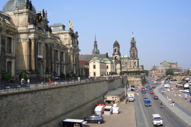
The Dresden fortifications were first mentioned in a document in 1299 and grew with the city until the de-fortification of Dresden at the beginning of the 19th century.
The Dresden fortress encircled the Inner Old Town. In its most recent state of expansion, its facilities extended in the east along today's St. Petersburger Straße and in the south approximately along today's Dr.-Külz-Ring. The names of the streets "An der Mauer" and "Wallstraße" running south and west of the Altmarkt refer to the fortifications formerly adjacent to them. In the northwest and north, the course of the fortress ring is still well traceable today, as parts of the buildings here have been preserved at the Zwinger and in the form of the Brühl Terrace and the Bärenzwinger.
Medieval Fortification+
The medieval city wall was first mentioned in a document in 1299. Its existence can be assumed decades earlier. At the time of the city's founding, a palisade fortification is assumed, archaeological findings suggest a construction period for the stone city fortification in the last quarter of the 12th century. In 1216, Dresden is documented as civitas, a clear indication of a city fortification.
The city wall was reinforced in the 14th century and during the Hussite Wars. In 1427, a second, low, outer wall was built, creating a Zwinger. Around the middle of the 15th century, these constructions were continued. At this time, bastion towers were erected on the walls and 15 wall towers at the Zwinger. A wooden walkway was built on part of the wall. Cannons were stored in so-called "Büchsenhäuser" (gun houses) in the Zwinger. There were also shooting ranges for crossbowmen and arquebusiers. Deer were kept in the castle moat. In front of the Zwinger wall was the city moat, which was fed by the Kaitzbach stream.
For defense, the city wall was divided into four (sometimes five) quarters.
A wooden city model, made during the time of Duke George the Bearded and showing the state of the city wall, was kept in the Green Vault until its destruction. Today, a replica is located in the Dresden City Museum.
The First City Gates+
Layout of the city of Dresden in 1529 by Anton Weck (1680; North is at the bottom): Wilsdorffer Thor (A, right), Elb-Thor (B, bottom), Ziegel-Thor (C, outer left bottom), Rampisch Thor (D, outer left), H. Creutzes Pforde (E, top left), See-Thor (F, top), Frauen-Thor (G, inner left).
Entry into the city was possible through five city gates. The gates were the Elbtor (or Brückentor), the Seetor, the Wilische Tor (or Wilsdruffer Tor), and the Frauentor, as well as the Kleine Kreuzpforte. The Elbtor was located in the north at the end of Schlossstraße in front of the Elbe Bridge, later the Augustusbrücke. In 1407, it was first mentioned as "Elbisches Tor", in 1455 as "Wasserthor" and in 1458 as "Brückenthor". Melchior Trost expanded it in 1553. With the construction of the Schloßplatz, it was demolished in 1738. The Seetor in the south of the city was first mentioned in 1403, it was located at the end of Seegasse and was walled up in 1550, the wall tower was converted into a prison by Melchior Trost. In the years 1747/1748, it was reopened and redesigned according to plans by Johann Georg Maximilian von Fürstenhoff, the illegitimate son of Johann Georg III, and was demolished in 1821. The Wilsche Tor was the western city gate at the end of Wilische Gasse. First mentioned in 1391, it was expanded at the beginning of the 15th century. Caspar Voigt von Wierandt expanded it in 1548 during the construction of the fortress. Due to dilapidation, Paul Buchner and Hans Irmisch undertook major renovations after 1568, such as the construction of a second floor with a roof hood and tower knob. The Wilsche Tor was demolished in 1811. The Frauentor was the easternmost city gate in the Middle Ages, it was mentioned in 1297 and was located at the end of the small Frauengasse. It provided the connection to the suburban settlements and to the Frauenkirche. After the inclusion of the settlements in the city in 1529, the gate lost its function and was removed in 1548 with the city wall that still separated the suburbs from the city. At the Frauentor, there was a cage, the so-called Narrenhäuschen (fools' house), where drunkards were put on display.
The Kleine Kreuzpforte was a small city gate, first mentioned in 1370. It was located at the end of Kreuzgasse, later Kreuzstraße. In 1592, it was walled up.
First Expansion of the City Fortification+
Between 1519 and 1529, the settlements on the Elbe and at the Frauenkirche were included in the first expansion of the city fortification, this happened by order of Duke George the Bearded. This "Newe Stadt" was protected by a rampart. The old city fortification remained in place for the time being. The Rampische Tor was built as a new gate in 1530. It replaced the Frauentor as the eastern city gate. Its location was approximately at the later Kurländer Palais. The name of the gate and the Rampische Gasse leading to it derives from the village of Ranvoltitz, abandoned in the 15th century. In addition to the inclusion of the suburban settlements, the remaining sections of the city wall were reinforced externally by earth embankments and by advanced outer works.
With the invention of gunpowder in the 14th century, the way was paved for cannons. Until then, the rule in fortress construction was: "The higher the wall, the safer." This led to a rethinking towards: "The more massive the fortification, the safer." Earth gained importance as a building material for fortifications, as it dampens the impulse of projectiles (see Plastic Impact).
Redesign by the First Albertine Electors+
Duke Moritz, who had risen to become one of the most important territorial lords within the Holy Roman Empire after gaining the electoral dignity in the Wittenberg Capitulation, had the medieval fortification expanded into a modern fortification system. He had learned about the Italian-Dutch defense system in Ghent and Antwerp.
The plans for the expansion came from the fortress master builder Caspar Voigt von Wierandt, Melchior Trost was the master stonemason. Work began in 1546 and continued after the Schmalkaldic War. Around 900 workers are said to have been employed in fortress construction around 1550. Already in 1548, the old city wall between the city and the eastern suburban settlement had been removed. The Rampische Tor was removed in 1552 with the construction of the Ziegel- and Salomonistor. The Elbtor was expanded, the Georgentor connected to it and the Seetor were walled up. The Ziegeltor (or Schifftor) was located on the Elbe side of the fortress wall at the northeast corner of the later Kunstakademie. During subsequent expansions of the city fortification, it was walled over. It can still be visited today in the Dresden Fortress Museum under the Brühl Terrace. The Salomonistor, built by Caspar Voigt von Wierandt, approximately took the place of the Kreuzpforte.
When Elector Moritz died in 1553, his brother and successor August had a monument erected for him at the point the fortress construction had reached at that time, the so-called Moritzmonument.
In 1568, the work was continued by Rochus zu Lynar and Paul Buchner. From 1589 to 1591, the last section of the new complex, the "new Vestung oder Berg am Ziegeltor" (new fortress or mountain at the Ziegeltor), was completed, which is the later Brühl Terrace. In connection with the completion of the Pirnaisches Tor in 1591 in the east of the complex, the Salomonistor in 1553 and the Ziegeltor were replaced and walled over. The Pirnaisches Tor was built by Paul Buchner, it was located at the end of Landhausstraße. On the gate was an equestrian statue of Elector Christian I. The statue was created by Andreas Walther III. It was destroyed in 1760. On the upper floor was the simply designed prison church, it was the house of worship for the fortress construction prisoners. It went back to a wooden prayer house on the Salominisbastion, which August the Strong had built in 1711. Fortress master builder Johann Gottfried Lohse rebuilt it in 1780 above the Pirnaisches Tor. In 1792 it was renovated. The preacher was Johann Christian Hasche. The Pirnaisches Tor was demolished in 1820, the church in 1824.
Names of the Fortifications+
The bastions of the new fortress bore names – from East to West these were: Jungfernbastei with upper and lower Ritterberg, Hasenberg (or Zeughausberg), Salomonisberg, Seeberg, Wilscher Berg, Baumschule with Zwingergraben and Feuerwerksplatz. The adjacent flanks of Baumschule and Feuerwerksplatz, at the location of the later opera house, were called the two Mönche, the area between Feuerwerksplatz and the bridge Münzberg, and the projection of the later Brühl Terrace (location of the Rietschel monument) Plattform. A monument on the Brühl Terrace by Vinzenz Wanitschke from 1990 commemorates the bastions.
By order of August the Strong, the names of the bastions were changed to Roman god names in 1721. The Jungfernbastei was called Venus, Hasenberg Mars, Salomonisberg Jupiter, Seeberg Mercury, Wilsdruffer Bastion Saturn, Baumschule Luna, and Feuerwerksplatz Sol.
Inclusion of Altendresden+
After the unification of Altendresden with Dresden on March 29, 1549, the expansions of the fortifications for Altendresden, which began in 1546, stalled. Only in 1632 was the fortification expanded.
Throughout the 18th century, the Altendresden or Neustadt fortifications were expanded several times, for example from 1704 to 1706, 1732, 1740, 1757, and 1796.
The bastions were continuously numbered with Roman numerals from I to VI from east to west. The protective wall between the Elbe and the city moat was called "Beyer" but also the designations "Beierwall", "Bär" and "Bartadeau" were used.
De-fortification+
After the city fortification had lost its military value in the middle of the 18th century, Dresden was de-fortified at the beginning of the 19th century, with a few exceptions.
For urban planning reasons and to gain building land, breaches were already made in the Old Town fortifications in the first half of the 18th century. For example, parts of the Luna Bastion were removed during the construction of the Zwinger, and in 1738, parts of the rampart were removed during the construction of the Catholic Court Church and the Schloßplatz. The first plans for complete de-fortification already existed in 1760 by the chief regional master builder Julius Heinrich Schwarze. However, these plans were rejected for military reasons. After the bombardment of Dresden by the Prussians in the Seven Years' War, the Bavarian court architect François de Cuvilliés drew up plans for complete de-fortification in 1762, but these plans could not be realized for financial reasons.
In 1809, presumably at the instigation of Napoleon I, the dismantling of the fortifications began. Around 1000 workers began demolishing the structures on November 20. Work in the Neustadt progressed quickly, as the city owned the ramparts. In the Altstadt, parts of the ramparts were privately owned, with gardens laid out on them. In April 1812, work was stopped, and in 1813, a new structure was even built. By order of the Russian governor Nikolai Grigoryevich Repnin-Wolkonski, a grand staircase was built from the Schloßplatz to the Brühl Terrace by Gottlob Friedrich Thormeyer in 1814, making it accessible to the public.
In April 1817, the dismantling work was continued under a "Demolition Commission," of which Thormeyer was also a member. Around 1829/1830, the de-fortification was completed.
From an urban planning and economic perspective, this decision was necessary for the growth of Dresden during the Industrial Revolution.
Preserved Parts of the Fortification+
The most famous part of the fortification still preserved today is the Brühl Terrace, under which the Dresden Fortress Museum is located. Nearby is also the so-called Bärenzwinger, a part of the Venus Bastion, which has been used as a student club since the late 1960s. Parts of the Luna Bastion are also preserved at the Zwinger. In the Palaisgarten, at the Japanese Palais, parts of Bastion VI of the Neustadt fortification are preserved.
The parts of the fortification located between the Elbe and the Old Town are integrated into the city's flood protection. In the event of an Elbe flood, the gates under the Brühl Terrace are sealed off by sheet piling. This protects the area of the Neumarkt around the Frauenkirche from surface water up to a water level of 9.24 meters. The Elbe reaches the walls of the fortification at a water level of approximately 5.20 meters.
Take Mobile History with you
You are reading this text for free. Premium adds what matters on the road: descriptions read aloud, sites found through your camera, whole regions taken offline.
- Every description, including the ~17,700 Premium sites
- Audio guide: have descriptions read to you on location
- AR finder: see sites through your camera, with distance and bearing
- Unlimited saved sites
14 days free, then from €2.99 a month. Cancel anytime.
Source: Wikipedia · Licence: CC BY-SA 4.0 · Image: http://commons.wikimedia.org/wiki/File:DD-Br%C3%BChlscheTerrasse.JPG
This description draws on the facts documented in the linked Wikipedia article; Wikipedia content is licensed under CC BY-SA 4.0. Wording and editing: Mobile History.
Location: 51.0534, 13.7417