The Fortress can be visited
FortressBourtange
Fort Bourtange
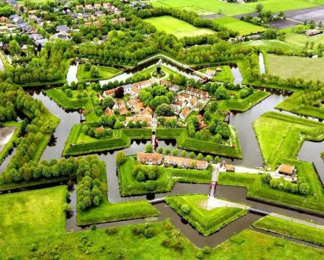
The Bourtange Fortress in the Netherlands is a unique historical structure that has been meticulously reconstructed after its decline. Located in the province of Groningen, it encloses a namesake fortified town, which today serves as a vibrant museum village.
History+
Construction of Bourtange Fortress began in 1580 during the Eighty Years' War. Its strategic purpose was to cut off supplies to the Spanish-held city of Groningen. Completed in 1593, the complex was continuously adapted to new military requirements during the Thirty Years' War. Despite numerous conflicts, Bourtange was never captured by an attacker. The fortress reached its largest extent in 1742 during the First Silesian War. In 1851, it lost its military significance, and the fortified town developed into a village. After World War II, the area faced depopulation, but in 1960, the municipality of Vlagtwedde decided to reconstruct the fortress to its 1742 state, preserving it as a museum and recreational destination. The main works took place between 1964 and 1973, and the complex has been continuously enhanced since then.
Location+
Bourtange Fortress is located in the town of Bourtange, in the Groningen district, Noord-Nederland region, Netherlands, at an elevation of approximately 11 m above sea level.
On site+
Visitors can explore the fully reconstructed Bourtange Fortress. It presents itself as a regular pentagon with bastions, surrounded by water-filled moats, ravelins, a crownwork, and a glacis. Within the fortress walls, there is a museum village with historic residential houses, a church, mills, defensive structures, and a restored synagogue. The complex also features an information center, museums, restaurants, and a hotel. During the summer half-year, regular events bring the fortress's history to life.
Nearby+
- Haus Nienhaus (manor house and estate), approx. 9.5 km away
- Schloss Altenkamp (castle), approx. 11.2 km away
- Haus Campe (manor house and estate), approx. 12.7 km away
- Haus Landegge (castle), approx. 21.2 km away
Take Mobile History with you
You are reading this text for free. Premium adds what matters on the road: descriptions read aloud, sites found through your camera, whole regions taken offline.
- Every description, including the ~17,700 Premium sites
- Audio guide: have descriptions read to you on location
- AR finder: see sites through your camera, with distance and bearing
- Unlimited saved sites
14 days free, then from €2.99 a month. Cancel anytime.
Source: Wikipedia · Licence: CC BY-SA 4.0
This description draws on the facts documented in the linked Wikipedia article; Wikipedia content is licensed under CC BY-SA 4.0. Wording and editing: Mobile History.
Location: 53.0067, 7.1917